Property Record
23 Elizabeth Dr, Chester, NY 10918
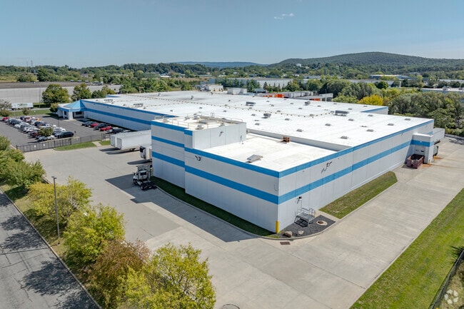

Property Detail
23 Elizabeth Dr
332201-119-000-0001-001.200-0000
LT 2 INDUSTR PK MAP 24-92
Industrialgeneral
Orange
M1
New York
AE The base floodplain where base flood elevations are provided. AE Zones are now used on new format FIRMs instead of A1-A30 Zones.
1.200
2024
9.10 AC
2025
Orange County
014301
Northern New Jersey
116,426 SF
Kiryas Joel-Poughkeepsie-Newburgh, NY
NEARBY LISTINGS FOR SALE OR LEASE
-
-
View all Chester listings for sale on LoopNet.com
DEMOGRAPHICS near 23 Elizabeth Dr
1 mile
3 mile
5 mile
2025 Total Population
2,374
11,248
37,710
2030 Population
2,425
11,437
38,443
Pop Growth 2025-2030
+ 2.15%
+ 1.68%
+ 1.94%
Average Age
41
41
41
2025 Total Households
954
4,027
13,203
HH Growth 2025-2030
+ 2.20%
+ 1.84%
+ 2.08%
Median Household Inc
$123,097
$120,410
$121,289
Avg Household Size
2.50
2.70
2.70
2025 Avg HH Vehicles
2.00
2.00
2.00
Median Home Value
$290,329
$426,863
$450,346
Median Year Built
1982
1978
1977
Nearby Places
Map Layers
Map Styles
 Street
 Aerial
Layers
 Traffic
 Biking
Places
Listings with unknown addresses are not visible on the map
- Restaurants
- Banks
- Shops
- Fitness
- Groceries
PUBLIC TRANSPORTATION
AIRPORT
New York Stewart International
Drive
Walk
Distance
New York Stewart International
32 min
16.6 mi
Freight Ports
Maher Terminal
Drive
Walk
Distance
Maher Terminal
84 min
61.8 mi
Nearby Properties
Address
Land Use
TOTAL SIZE
Lot Size
Zoning
Address
Land Use
TOTAL SIZE
Lot Size
Zoning
389 AC
02092
Address
Land Use
TOTAL SIZE
Lot Size
Zoning
878,010 SF
50.40 AC
Address
Land Use
TOTAL SIZE
Lot Size
Zoning
1,313,710 SF
34 AC
SR2*
Address
Land Use
TOTAL SIZE
Lot Size
Zoning
221,073 SF
35.40 AC
04023
Address
Land Use
TOTAL SIZE
Lot Size
Zoning
198,260 SF
27.60 AC
B2
Address
Land Use
TOTAL SIZE
Lot Size
Zoning
50.30 AC
I
Address
Land Use
TOTAL SIZE
Lot Size
Zoning
404,550 SF
35.90 AC
M1
Address
Land Use
TOTAL SIZE
Lot Size
Zoning
319,144 SF
47.80 AC
IP
Address
Land Use
TOTAL SIZE
Lot Size
Zoning
100,324 SF
15.80 AC
RS
Address
Land Use
TOTAL SIZE
Lot Size
Zoning
211,990 SF
13.10 AC
M1
Address
Land Use
TOTAL SIZE
Lot Size
Zoning
194,400 SF
28.10 AC
I
Address
Land Use
TOTAL SIZE
Lot Size
Zoning
92,969 SF
4.98 AC
M1
Address
Land Use
TOTAL SIZE
Lot Size
Zoning
282,147 SF
7.50 AC
M2
Address
Land Use
TOTAL SIZE
Lot Size
Zoning
5 AC
IP
Address
Land Use
TOTAL SIZE
Lot Size
Zoning
52,575 SF
64.60 AC
AR3*
Address
Land Use
TOTAL SIZE
Lot Size
Zoning
71,910 SF
10.80 AC
Address
Land Use
TOTAL SIZE
Lot Size
Zoning
61,975 SF
10.80 AC
M1
Address
Land Use
TOTAL SIZE
Lot Size
Zoning
159,063 SF
18.80 AC
M1
Address
Land Use
TOTAL SIZE
Lot Size
Zoning
86,696 SF
153.50 AC
A1OP
Address
Land Use
TOTAL SIZE
Lot Size
Zoning
19,440 SF
6.80 AC
RM
Address
Land Use
TOTAL SIZE
Lot Size
Zoning
101,476 SF
6.30 AC
M1
Address
Land Use
TOTAL SIZE
Lot Size
Zoning
82,927 SF
10.10 AC
4500
Address
Land Use
TOTAL SIZE
Lot Size
Zoning
43,664 SF
3.10 AC
B2
Address
Land Use
TOTAL SIZE
Lot Size
Zoning
43,738 SF
16.90 AC
GC
Address
Land Use
TOTAL SIZE
Lot Size
Zoning
63,068 SF
10.80 AC
M1
Address
Land Use
TOTAL SIZE
Lot Size
Zoning
43,952 SF
14.10 AC
B2
Address
Land Use
TOTAL SIZE
Lot Size
Zoning
72,430 SF
5.60 AC
M2
Address
Land Use
TOTAL SIZE
Lot Size
Zoning
88,440 SF
4.50 AC
M1
Address
Land Use
TOTAL SIZE
Lot Size
Zoning
33,380 SF
2.60 AC
B2
The World's #1 Commercial Real Estate Marketplace
Connect with us
© 2026 CoStar Group
The information above has been obtained from sources believed reliable. While we do not doubt its accuracy we have not verified it and make no guarantee, warranty or representation about it. It is your responsibility to independently confirm its accuracy and completeness. Any projections, opinions, assumptions, or estimates used are for example only and do not represent the current or future performance of the property. The value of this transaction to you depends on tax and other factors which should be evaluated by your tax, financial, and legal advisors. You and your advisors should conduct a careful, independent investigation of the property to determine to your satisfaction the suitability of the property for your needs.