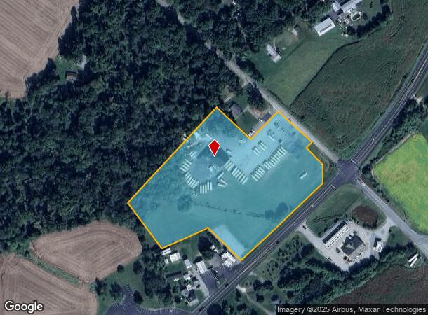
Property Record
23 Firetower Rd, Port Deposit, MD 21904

NEARBY LISTINGS FOR SALE OR LEASE
-
-
View all Port Deposit listings for sale on LoopNet.com
Property Detail
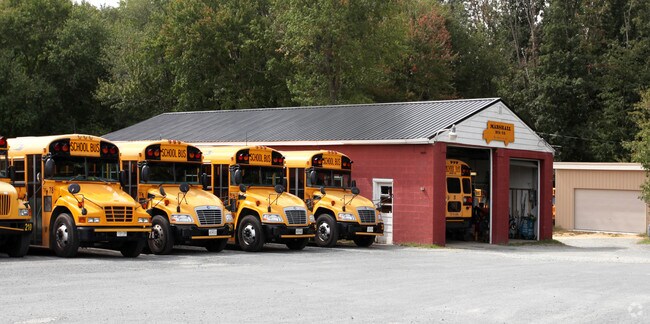
23 Firetower Rd
06-028659
Woodlawn
Warehouse
7.734 ACRES 23 FIRETOWER ROAD WOODLAWN
X
Cecil
24015C0050D
Maryland
2025
7.73 AC
2025
Cecil County
031301
Baltimore
5,600 SF
Philadelphia-Camden-Wilmington, PA-NJ-DE-MD
DEMOGRAPHICS near 23 Firetower Rd
1 Mile
3 Mile
5 Mile
2024 Total Population
1,643
8,630
21,304
2029 Population
1,679
8,810
21,643
Pop Growth 2024-2029
+ 2.19%
+ 2.09%
+ 1.59%
Average Age
42
42
42
2024 Total Households
630
3,246
7,981
HH Growth 2024-2029
+ 2.38%
+ 2.25%
+ 1.70%
Median Household Inc
$76,630
$82,961
$82,622
Avg Household Size
2.60
2.60
2.60
2024 Avg HH Vehicles
2.00
2.00
2.00
Median Home Value
$258,659
$300,843
$299,879
Median Year Built
1983
1984
1983
Nearby Places
Map Layers
Map Styles
 Street
 Aerial
- Restaurants
- Banks
- Shops
- Fitness
- Groceries
PUBLIC TRANSPORTATION
COMMUTER RAIL
Perryville (PENN - WASHINGTON - Maryland Area Regional Commuter Trains (The MARC), Penn Line - Maryland Area Regional Commuter Trains (The MARC))
DRIVE
WALK
Distance
Perryville (PENN - WASHINGTON - Maryland Area Regional Commuter Trains (The MARC), Penn Line - Maryland Area Regional Commuter Trains (The MARC))
11 min
6.2 mi
Freight Ports
Port of Wilmington, RI
DRIVE
WALK
Distance
Port of Wilmington, RI
46 min
36.1 mi
Nearby Properties
Address
Land Use
TOTAL SIZE
Lot Size
Zoning
Address
Land Use
TOTAL SIZE
Lot Size
Zoning
1,026,000 SF
114.22 AC
Address
Land Use
TOTAL SIZE
Lot Size
Zoning
601,549 SF
95.21 AC
Address
Land Use
TOTAL SIZE
Lot Size
Zoning
68,345 SF
30.07 AC
CEMUD
Address
Land Use
TOTAL SIZE
Lot Size
Zoning
12,128 SF
56.42 AC
NAR
Address
Land Use
TOTAL SIZE
Lot Size
Zoning
13,660 SF
11 AC
DR
Address
Land Use
TOTAL SIZE
Lot Size
Zoning
55,386 SF
14.99 AC
ST
Address
Land Use
TOTAL SIZE
Lot Size
Zoning
44.75 AC
MH
Address
Land Use
TOTAL SIZE
Lot Size
Zoning
742.64 AC
BMU
Address
Land Use
TOTAL SIZE
Lot Size
Zoning
40.69 AC
MH
Address
Land Use
TOTAL SIZE
Lot Size
Zoning
21.16 AC
MH
Address
Land Use
TOTAL SIZE
Lot Size
Zoning
27.14 AC
MH
Address
Land Use
TOTAL SIZE
Lot Size
Zoning
792 SF
10.95 AC
BG
Address
Land Use
TOTAL SIZE
Lot Size
Zoning
3,706 SF
10 AC
RR
Address
Land Use
TOTAL SIZE
Lot Size
Zoning
1.42 AC
C2
Address
Land Use
TOTAL SIZE
Lot Size
Zoning
29,112 SF
2.70 AC
RC
Address
Land Use
TOTAL SIZE
Lot Size
Zoning
6,958 SF
5 AC
BI
Address
Land Use
TOTAL SIZE
Lot Size
Zoning
9.83 AC
MH
Address
Land Use
TOTAL SIZE
Lot Size
Zoning
6,080 SF
3.56 AC
NAR
Address
Land Use
TOTAL SIZE
Lot Size
Zoning
28.43 AC
RR
Address
Land Use
TOTAL SIZE
Lot Size
Zoning
19.76 AC
MH
Address
Land Use
TOTAL SIZE
Lot Size
Zoning
17,500 SF
12.32 AC
BG
Address
Land Use
TOTAL SIZE
Lot Size
Zoning
6.21 AC
CEMUD
Address
Land Use
TOTAL SIZE
Lot Size
Zoning
9,440 SF
10.12 AC
RR
Address
Land Use
TOTAL SIZE
Lot Size
Zoning
155.10 AC
LDR
Address
Land Use
TOTAL SIZE
Lot Size
Zoning
23,400 SF
7.65 AC
SPLIT
Address
Land Use
TOTAL SIZE
Lot Size
Zoning
2,180 SF
8.03 AC
SPLIT
Address
Land Use
TOTAL SIZE
Lot Size
Zoning
640 SF
6.07 AC
MH
Address
Land Use
TOTAL SIZE
Lot Size
Zoning
45.47 AC
NAR
Address
Land Use
TOTAL SIZE
Lot Size
Zoning
640 SF
86.68 AC
M2
Address
Land Use
TOTAL SIZE
Lot Size
Zoning
15,801 SF
0.69 AC
CR
The World's #1 Commercial Real Estate Marketplace
Connect with us
© 2025 CoStar Group
The information above has been obtained from sources believed reliable. While we do not doubt its accuracy we have not verified it and make no guarantee, warranty or representation about it. It is your responsibility to independently confirm its accuracy and completeness. Any projections, opinions, assumptions, or estimates used are for example only and do not represent the current or future performance of the property. The value of this transaction to you depends on tax and other factors which should be evaluated by your tax, financial, and legal advisors. You and your advisors should conduct a careful, independent investigation of the property to determine to your satisfaction the suitability of the property for your needs.