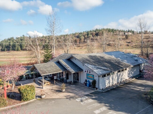
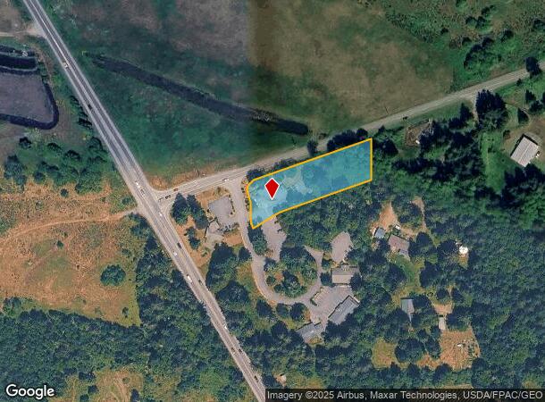
Property Record
23 Kala Square Pl, Port Townsend, WA 98368

NEARBY LISTINGS FOR SALE OR LEASE
Property Detail
23 Kala Square Pl
001342038
Kala Square Binding Site Plan
Storebuilding
KALA SQUARE BINDING SITE PLAN LOT 8 AMENDED V1 P82 SUBJ TO EASE/REST OF RECORD
X
Jefferson
53031C0145C
Washington
2024
8
2024
1.01 AC
950400
Bellingham/Northwest
3,012 SF
Other Market Areas
DEMOGRAPHICS near 23 Kala Square Pl
1 Mile
3 Mile
5 Mile
2024 Total Population
1,065
6,502
16,331
2029 Population
1,127
6,851
17,338
Pop Growth 2024-2029
+ 5.82%
+ 5.37%
+ 6.17%
Average Age
51
50
51
2024 Total Households
487
3,000
7,839
HH Growth 2024-2029
+ 5.95%
+ 5.27%
+ 6.17%
Median Household Inc
$70,641
$62,050
$58,787
Avg Household Size
2.20
2.20
2.10
2024 Avg HH Vehicles
2.00
2.00
2.00
Median Home Value
$416,778
$414,098
$431,214
Median Year Built
1987
1986
1986
Nearby Places
Map Layers
Map Styles
 Street
 Aerial
- Restaurants
- Banks
- Shops
- Fitness
- Groceries
PUBLIC TRANSPORTATION
AIRPORT
Seattle Paine Field International
DRIVE
WALK
Distance
Seattle Paine Field International
96 min
45.1 mi
Freight Ports
Port of Everett
DRIVE
WALK
Distance
Port of Everett
106 min
53.1 mi
SALE & LEASE HISTORY
LISTING DATE
SALE/LEASE

Mar 20, 2020
For Sale
Nearby Properties
Address
Land Use
TOTAL SIZE
Lot Size
Zoning
Address
Land Use
TOTAL SIZE
Lot Size
Zoning
51,440 SF
84.16 AC
PPR
Address
Land Use
TOTAL SIZE
Lot Size
Zoning
76,012 SF
8.45 AC
GC
Address
Land Use
TOTAL SIZE
Lot Size
Zoning
29,088 SF
Address
Land Use
TOTAL SIZE
Lot Size
Zoning
36,852 SF
8.67 AC
GC
Address
Land Use
TOTAL SIZE
Lot Size
Zoning
21.02 AC
RR-5
Address
Land Use
TOTAL SIZE
Lot Size
Zoning
25,465 SF
8.95 AC
UGA-C
Address
Land Use
TOTAL SIZE
Lot Size
Zoning
1.96 AC
UGA-VC
Address
Land Use
TOTAL SIZE
Lot Size
Zoning
13,341 SF
10.63 AC
RR-10
Address
Land Use
TOTAL SIZE
Lot Size
Zoning
60,356 SF
1.85 AC
LI/C
Address
Land Use
TOTAL SIZE
Lot Size
Zoning
36,176 SF
1.95 AC
LI
Address
Land Use
TOTAL SIZE
Lot Size
Zoning
25,418 SF
2.29 AC
UGA-C
Address
Land Use
TOTAL SIZE
Lot Size
Zoning
10,749 SF
6.53 AC
RR-5
Address
Land Use
TOTAL SIZE
Lot Size
Zoning
5,060 SF
31.45 AC
RR-5
Address
Land Use
TOTAL SIZE
Lot Size
Zoning
29,590 SF
2.26 AC
UGA-C
Address
Land Use
TOTAL SIZE
Lot Size
Zoning
24,078 SF
36.50 AC
EPF-A
Address
Land Use
TOTAL SIZE
Lot Size
Zoning
6,794 SF
12.03 AC
RR-5
Address
Land Use
TOTAL SIZE
Lot Size
Zoning
36,940 SF
2.51 AC
NC
Address
Land Use
TOTAL SIZE
Lot Size
Zoning
32,400 SF
2.19 AC
LI/C
Address
Land Use
TOTAL SIZE
Lot Size
Zoning
2,104 SF
4.95 AC
NC
Address
Land Use
TOTAL SIZE
Lot Size
Zoning
7,076 SF
2.03 AC
LI/C
Address
Land Use
TOTAL SIZE
Lot Size
Zoning
4,800 SF
5.26 AC
UGA-C
Address
Land Use
TOTAL SIZE
Lot Size
Zoning
51,340 SF
5.52 AC
NC
Address
Land Use
TOTAL SIZE
Lot Size
Zoning
252 AC
CF-80
Address
Land Use
TOTAL SIZE
Lot Size
Zoning
695 SF
12.64 AC
RR-10
Address
Land Use
TOTAL SIZE
Lot Size
Zoning
2,791 SF
38 AC
PPR
Address
Land Use
TOTAL SIZE
Lot Size
Zoning
6,563 SF
5.04 AC
UGA-C
Address
Land Use
TOTAL SIZE
Lot Size
Zoning
9,540 SF
2.51 AC
Address
Land Use
TOTAL SIZE
Lot Size
Zoning
9,156 SF
1.97 AC
LI
Address
Land Use
TOTAL SIZE
Lot Size
Zoning
11,100 SF
1.13 AC
UGA-C
Address
Land Use
TOTAL SIZE
Lot Size
Zoning
14,000 SF
1.79 AC
LI
The World's #1 Commercial Real Estate Marketplace
Connect with us
© 2025 CoStar Group
The information above has been obtained from sources believed reliable. While we do not doubt its accuracy we have not verified it and make no guarantee, warranty or representation about it. It is your responsibility to independently confirm its accuracy and completeness. Any projections, opinions, assumptions, or estimates used are for example only and do not represent the current or future performance of the property. The value of this transaction to you depends on tax and other factors which should be evaluated by your tax, financial, and legal advisors. You and your advisors should conduct a careful, independent investigation of the property to determine to your satisfaction the suitability of the property for your needs.