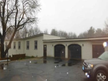
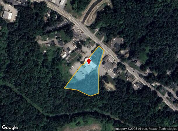
Property Record
23 Main St, Sturbridge, MA 01566
NEARBY LISTINGS FOR SALE OR LEASE
Property Detail
23 Main St
STUR-000415-000000-003923-000023
Worcester
Charitableorganization
Massachusetts
X
3923-23
09015C0025F
2.75 AC
2024
Outlying Worcester
2025
Boston
758104
Worcester, MA
16,152 SF
DEMOGRAPHICS near 23 Main St
1 Mile
3 Mile
5 Mile
2024 Total Population
4,691
21,212
30,281
2029 Population
4,635
21,110
30,163
Pop Growth 2024-2029
(1.19%)
(0.48%)
(0.39%)
Average Age
40
41
41
2024 Total Households
1,882
8,751
12,335
HH Growth 2024-2029
(1.22%)
(0.50%)
(0.41%)
Median Household Inc
$65,320
$59,456
$69,415
Avg Household Size
2.40
2.40
2.40
2024 Avg HH Vehicles
2.00
2.00
2.00
Median Home Value
$299,469
$292,764
$319,714
Median Year Built
1948
1955
1964
Nearby Places
Map Layers
Map Styles
 Street
 Aerial
- Restaurants
- Banks
- Shops
- Fitness
- Groceries
PUBLIC TRANSPORTATION
AIRPORT
Worcester Regional
DRIVE
WALK
Distance
Worcester Regional
38 min
20.7 mi
Freight Ports
Port of Davisville, RI
DRIVE
WALK
Distance
Port of Davisville, RI
92 min
66.6 mi
Nearby Properties
Address
Land Use
TOTAL SIZE
Lot Size
Zoning
Address
Land Use
TOTAL SIZE
Lot Size
Zoning
1,800 SF
10.02 AC
IG
Address
Land Use
TOTAL SIZE
Lot Size
Zoning
15,648 SF
50.82 AC
A
Address
Land Use
TOTAL SIZE
Lot Size
Zoning
201,329 SF
90 AC
R1
Address
Land Use
TOTAL SIZE
Lot Size
Zoning
127,762 SF
19.28 AC
Address
Land Use
TOTAL SIZE
Lot Size
Zoning
127,620 SF
6.40 AC
R2
Address
Land Use
TOTAL SIZE
Lot Size
Zoning
45.13 AC
GB
Address
Land Use
TOTAL SIZE
Lot Size
Zoning
Address
Land Use
TOTAL SIZE
Lot Size
Zoning
10.08 AC
M
Address
Land Use
TOTAL SIZE
Lot Size
Zoning
102,966 SF
30.95 AC
Address
Land Use
TOTAL SIZE
Lot Size
Zoning
Address
Land Use
TOTAL SIZE
Lot Size
Zoning
2.14 AC
CC
Address
Land Use
TOTAL SIZE
Lot Size
Zoning
93,260 SF
9.10 AC
R1
Address
Land Use
TOTAL SIZE
Lot Size
Zoning
208,444 SF
14.09 AC
Address
Land Use
TOTAL SIZE
Lot Size
Zoning
13 AC
M
Address
Land Use
TOTAL SIZE
Lot Size
Zoning
76,237 SF
7.50 AC
R1
Address
Land Use
TOTAL SIZE
Lot Size
Zoning
100,771 SF
2.70 AC
R2
Address
Land Use
TOTAL SIZE
Lot Size
Zoning
Address
Land Use
TOTAL SIZE
Lot Size
Zoning
4,704 SF
76 AC
Address
Land Use
TOTAL SIZE
Lot Size
Zoning
58,420 SF
5 AC
R2
Address
Land Use
TOTAL SIZE
Lot Size
Zoning
105,660 SF
Address
Land Use
TOTAL SIZE
Lot Size
Zoning
93,552 SF
40.84 AC
Address
Land Use
TOTAL SIZE
Lot Size
Zoning
89,656 SF
0.97 AC
RB
Address
Land Use
TOTAL SIZE
Lot Size
Zoning
15,000 SF
2 AC
Address
Land Use
TOTAL SIZE
Lot Size
Zoning
5,024 SF
10.60 AC
Address
Land Use
TOTAL SIZE
Lot Size
Zoning
1 AC
CC
Address
Land Use
TOTAL SIZE
Lot Size
Zoning
9.58 AC
R3
Address
Land Use
TOTAL SIZE
Lot Size
Zoning
7.86 AC
OR
Address
Land Use
TOTAL SIZE
Lot Size
Zoning
43,817 SF
3.17 AC
Address
Land Use
TOTAL SIZE
Lot Size
Zoning
10,210 SF
116.40 AC
R1
Address
Land Use
TOTAL SIZE
Lot Size
Zoning
22,204 SF
2.50 AC
CC
The World's #1 Commercial Real Estate Marketplace
Connect with us
© 2026 CoStar Group
The information above has been obtained from sources believed reliable. While we do not doubt its accuracy we have not verified it and make no guarantee, warranty or representation about it. It is your responsibility to independently confirm its accuracy and completeness. Any projections, opinions, assumptions, or estimates used are for example only and do not represent the current or future performance of the property. The value of this transaction to you depends on tax and other factors which should be evaluated by your tax, financial, and legal advisors. You and your advisors should conduct a careful, independent investigation of the property to determine to your satisfaction the suitability of the property for your needs.