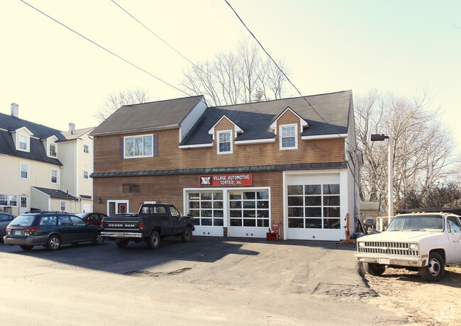
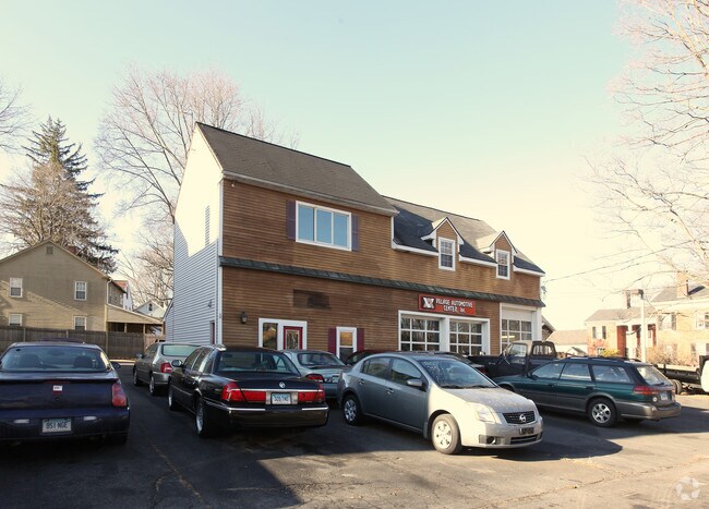
Property Record
23 Main St, Tariffville, CT 06081
NEARBY LISTINGS FOR SALE OR LEASE
Property Detail
23 Main St
SIMS-000003K-000219-000024
Hartford
Parkingstructure
Connecticut
X
24
09003C0192F
0.12 AC
2025
Simsbury
2025
Hartford
466400
Hartford-West Hartford-East Hartford, CT
2,323 SF
DEMOGRAPHICS near 23 Main St
1 Mile
3 Mile
5 Mile
2024 Total Population
2,051
14,695
36,073
2029 Population
2,056
14,615
35,932
Pop Growth 2024-2029
+ 0.24%
(0.54%)
(0.39%)
Average Age
41
42
44
2024 Total Households
904
6,023
14,483
HH Growth 2024-2029
+ 0.22%
(0.58%)
(0.46%)
Median Household Inc
$93,395
$112,278
$113,529
Avg Household Size
2.30
2.40
2.40
2024 Avg HH Vehicles
2.00
2.00
2.00
Median Home Value
$257,954
$321,637
$326,337
Median Year Built
1961
1971
1975
Nearby Places
Map Layers
Map Styles
 Street
 Aerial
- Restaurants
- Banks
- Shops
- Fitness
- Groceries
PUBLIC TRANSPORTATION
COMMUTER RAIL
DRIVE
WALK
Distance
17 min
8.8 mi
AIRPORT
Bradley International
DRIVE
WALK
Distance
Bradley International
22 min
8.0 mi
Nearby Properties
Address
Land Use
TOTAL SIZE
Lot Size
Zoning
Address
Land Use
TOTAL SIZE
Lot Size
Zoning
221,054 SF
28.85 AC
R-40
Address
Land Use
TOTAL SIZE
Lot Size
Zoning
100,414 SF
93.10 AC
Address
Land Use
TOTAL SIZE
Lot Size
Zoning
9,882 SF
181.60 AC
R-40
Address
Land Use
TOTAL SIZE
Lot Size
Zoning
93.79 AC
Address
Land Use
TOTAL SIZE
Lot Size
Zoning
130.99 AC
Address
Land Use
TOTAL SIZE
Lot Size
Zoning
10.26 AC
PAD
Address
Land Use
TOTAL SIZE
Lot Size
Zoning
89,800 SF
20.20 AC
R-40
Address
Land Use
TOTAL SIZE
Lot Size
Zoning
34.66 AC
T1
Address
Land Use
TOTAL SIZE
Lot Size
Zoning
304,200 SF
58.46 AC
Address
Land Use
TOTAL SIZE
Lot Size
Zoning
1,576 SF
9.52 AC
T1
Address
Land Use
TOTAL SIZE
Lot Size
Zoning
152,382 SF
10.46 AC
Address
Land Use
TOTAL SIZE
Lot Size
Zoning
234,000 SF
16.50 AC
Address
Land Use
TOTAL SIZE
Lot Size
Zoning
457,396 SF
72.99 AC
Address
Land Use
TOTAL SIZE
Lot Size
Zoning
242,000 SF
20.30 AC
Address
Land Use
TOTAL SIZE
Lot Size
Zoning
52.32 AC
R20
Address
Land Use
TOTAL SIZE
Lot Size
Zoning
162,847 SF
18.53 AC
I-2
Address
Land Use
TOTAL SIZE
Lot Size
Zoning
253,862 SF
36.38 AC
I-2
Address
Land Use
TOTAL SIZE
Lot Size
Zoning
26,941 SF
3.58 AC
SCZ
Address
Land Use
TOTAL SIZE
Lot Size
Zoning
49,484 SF
14 AC
R-15
Address
Land Use
TOTAL SIZE
Lot Size
Zoning
148,415 SF
19.42 AC
Address
Land Use
TOTAL SIZE
Lot Size
Zoning
37,178 SF
4.40 AC
R-25
Address
Land Use
TOTAL SIZE
Lot Size
Zoning
70,317 SF
17.08 AC
I-1
Address
Land Use
TOTAL SIZE
Lot Size
Zoning
49,808 SF
7.19 AC
B-2
Address
Land Use
TOTAL SIZE
Lot Size
Zoning
148,884 SF
15.40 AC
Address
Land Use
TOTAL SIZE
Lot Size
Zoning
138,891 SF
16.46 AC
Address
Land Use
TOTAL SIZE
Lot Size
Zoning
138,891 SF
15.39 AC
Address
Land Use
TOTAL SIZE
Lot Size
Zoning
136,500 SF
12.20 AC
Address
Land Use
TOTAL SIZE
Lot Size
Zoning
126,839 SF
9.22 AC
Address
Land Use
TOTAL SIZE
Lot Size
Zoning
115,200 SF
13.11 AC
Address
Land Use
TOTAL SIZE
Lot Size
Zoning
99,840 SF
12.81 AC
The World's #1 Commercial Real Estate Marketplace
Connect with us
© 2025 CoStar Group
The information above has been obtained from sources believed reliable. While we do not doubt its accuracy we have not verified it and make no guarantee, warranty or representation about it. It is your responsibility to independently confirm its accuracy and completeness. Any projections, opinions, assumptions, or estimates used are for example only and do not represent the current or future performance of the property. The value of this transaction to you depends on tax and other factors which should be evaluated by your tax, financial, and legal advisors. You and your advisors should conduct a careful, independent investigation of the property to determine to your satisfaction the suitability of the property for your needs.