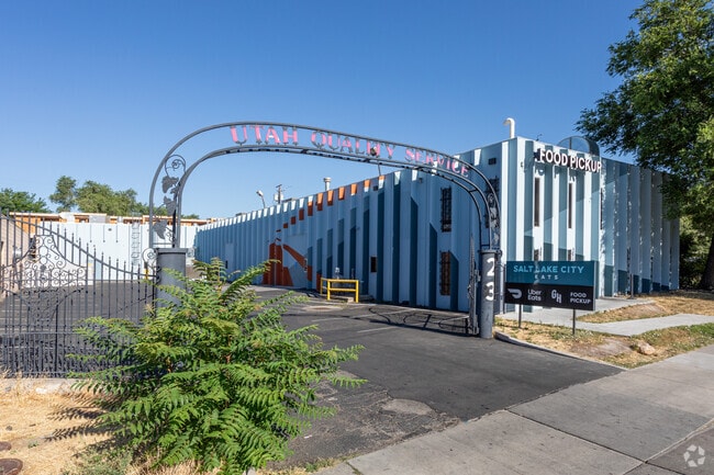
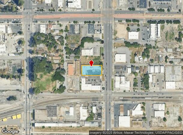
Property Record
23 N 900 W, Salt Lake City, UT 84116


Current Lease Availabilities
NEARBY LISTINGS FOR SALE OR LEASE
Property Detail
23 N 900 W
Salt Lake City, UT
Salt Lake City Survey
08-35-456-024-0000
BEG N 00^13?33? E 148.55 FT FR SE COR LOT 1, BLK 57, PLAT C;N 89^46?21? W 198.15 FT; N 00^13?37? E 99.06 FT; S 89^45?45?E 198.15 FT; S 00^13?37? W 99.06 FT TO BEG.
Multipleuses
Salt Lake
X
Utah
49011C0525E
1
2023
0.45 AC
2025
CBD/Periphery
102600
Salt Lake City
10,652 SF
DEMOGRAPHICS near 23 N 900 W
1 Mile
3 Mile
5 Mile
2024 Total Population
19,518
122,119
208,238
2029 Population
20,186
125,069
211,966
Pop Growth 2024-2029
+ 3.42%
+ 2.42%
+ 1.79%
Average Age
36
36
36
2024 Total Households
8,547
53,950
88,488
HH Growth 2024-2029
+ 4.34%
+ 3.02%
+ 2.21%
Median Household Inc
$53,586
$57,132
$61,001
Avg Household Size
2.10
2.10
2.20
2024 Avg HH Vehicles
1.00
1.00
2.00
Median Home Value
$296,955
$386,180
$448,578
Median Year Built
2001
1975
1970
Nearby Places
Map Layers
Map Styles
 Street
 Aerial
- Restaurants
- Banks
- Shops
- Fitness
- Groceries
PUBLIC TRANSPORTATION
TRANSIT/SUBWAY
Jackson/Euclid Station (Green Line - Utah Transit Authority (UTA))
DRIVE
WALK
Distance
Jackson/Euclid Station (Green Line - Utah Transit Authority (UTA))
0 min
3 min
0.2 mi
Fairpark Station (Green Line - Utah Transit Authority (UTA))
DRIVE
WALK
Distance
Fairpark Station (Green Line - Utah Transit Authority (UTA))
2 min
9 min
0.5 mi
North Temple Bridge/Guadalupe (Green Line - Utah Transit Authority (UTA))
DRIVE
WALK
Distance
North Temple Bridge/Guadalupe (Green Line - Utah Transit Authority (UTA))
2 min
14 min
0.7 mi
Old Greektown Station (Blue Line - Utah Transit Authority (UTA))
DRIVE
WALK
Distance
Old Greektown Station (Blue Line - Utah Transit Authority (UTA))
2 min
17 min
0.9 mi
Salt Lake Central Station (FrontRunner North - Utah Transit Authority (UTA), TRAX Salt Lake/Sandy Line - Utah Transit Authority (UTA), TRAX University Line - Utah Transit Authority (UTA))
DRIVE
WALK
Distance
Salt Lake Central Station (FrontRunner North - Utah Transit Authority (UTA), TRAX Salt Lake/Sandy Line - Utah Transit Authority (UTA), TRAX University Line - Utah Transit Authority (UTA))
2 min
18 min
0.9 mi
COMMUTER RAIL
North Temple Station (FrontRunner - Utah Transit Authority (UTA))
DRIVE
WALK
Distance
North Temple Station (FrontRunner - Utah Transit Authority (UTA))
3 min
15 min
0.8 mi
Warm Springs Relief Point (FrontRunner - Utah Transit Authority (UTA))
DRIVE
WALK
Distance
Warm Springs Relief Point (FrontRunner - Utah Transit Authority (UTA))
6 min
2.4 mi
AIRPORT
Salt Lake City International
DRIVE
WALK
Distance
Salt Lake City International
11 min
5.3 mi
Freight Ports
Port of Stockton
DRIVE
WALK
Distance
Port of Stockton
712 min
695.7 mi
Nearby Properties
Address
Land Use
TOTAL SIZE
Lot Size
Zoning
Address
Land Use
TOTAL SIZE
Lot Size
Zoning
1,115,174 SF
9.72 AC
D-4
Address
Land Use
TOTAL SIZE
Lot Size
Zoning
352,836 SF
20.05 AC
PL
Address
Land Use
TOTAL SIZE
Lot Size
Zoning
350,000 SF
10 AC
U1
Address
Land Use
TOTAL SIZE
Lot Size
Zoning
56,741 SF
1.70 AC
D-1
Address
Land Use
TOTAL SIZE
Lot Size
Zoning
87,933 SF
4.90 AC
D-1
Address
Land Use
TOTAL SIZE
Lot Size
Zoning
2,566,335 SF
10.01 AC
D-1
Address
Land Use
TOTAL SIZE
Lot Size
Zoning
205,570 SF
5.63 AC
UI
Address
Land Use
TOTAL SIZE
Lot Size
Zoning
1,849,748 SF
6.88 AC
D-1
Address
Land Use
TOTAL SIZE
Lot Size
Zoning
1,330,058 SF
5.02 AC
D2
Address
Land Use
TOTAL SIZE
Lot Size
Zoning
836,183 SF
5.89 AC
TSA-UC
Address
Land Use
TOTAL SIZE
Lot Size
Zoning
807,940 SF
0.69 AC
D1
Address
Land Use
TOTAL SIZE
Lot Size
Zoning
712,539 SF
0.01 AC
D1
Address
Land Use
TOTAL SIZE
Lot Size
Zoning
1,256,042 SF
3.50 AC
D-1
Address
Land Use
TOTAL SIZE
Lot Size
Zoning
82,851 SF
9.76 AC
PL2
Address
Land Use
TOTAL SIZE
Lot Size
Zoning
588,291 SF
1.28 AC
D-1
Address
Land Use
TOTAL SIZE
Lot Size
Zoning
434,481 SF
10 AC
D-1
Address
Land Use
TOTAL SIZE
Lot Size
Zoning
157,938 SF
12 AC
1205
Address
Land Use
TOTAL SIZE
Lot Size
Zoning
146,422 SF
2.62 AC
UI
Address
Land Use
TOTAL SIZE
Lot Size
Zoning
449,528 SF
1.64 AC
2000
Address
Land Use
TOTAL SIZE
Lot Size
Zoning
543,780 SF
0.33 AC
D1
Address
Land Use
TOTAL SIZE
Lot Size
Zoning
454,036 SF
1.64 AC
D-1
Address
Land Use
TOTAL SIZE
Lot Size
Zoning
0.01 AC
D-4
Address
Land Use
TOTAL SIZE
Lot Size
Zoning
737,755 SF
1.63 AC
D-1
Address
Land Use
TOTAL SIZE
Lot Size
Zoning
22,022 SF
308 AC
AIRPRT
Address
Land Use
TOTAL SIZE
Lot Size
Zoning
37,536 SF
10 AC
PL
Address
Land Use
TOTAL SIZE
Lot Size
Zoning
208,868 SF
20.41 AC
I
Address
Land Use
TOTAL SIZE
Lot Size
Zoning
366,584 SF
1.95 AC
TSAUC
Address
Land Use
TOTAL SIZE
Lot Size
Zoning
617,901 SF
2.73 AC
TSA-UC
Address
Land Use
TOTAL SIZE
Lot Size
Zoning
695,737 SF
1.70 AC
D-1
Address
Land Use
TOTAL SIZE
Lot Size
Zoning
248,345 SF
50 AC
PL
The World's #1 Commercial Real Estate Marketplace
Connect with us
© 2025 CoStar Group
The information above has been obtained from sources believed reliable. While we do not doubt its accuracy we have not verified it and make no guarantee, warranty or representation about it. It is your responsibility to independently confirm its accuracy and completeness. Any projections, opinions, assumptions, or estimates used are for example only and do not represent the current or future performance of the property. The value of this transaction to you depends on tax and other factors which should be evaluated by your tax, financial, and legal advisors. You and your advisors should conduct a careful, independent investigation of the property to determine to your satisfaction the suitability of the property for your needs.