Property Record
23 N Farview Ave, Paramus, NJ 07652
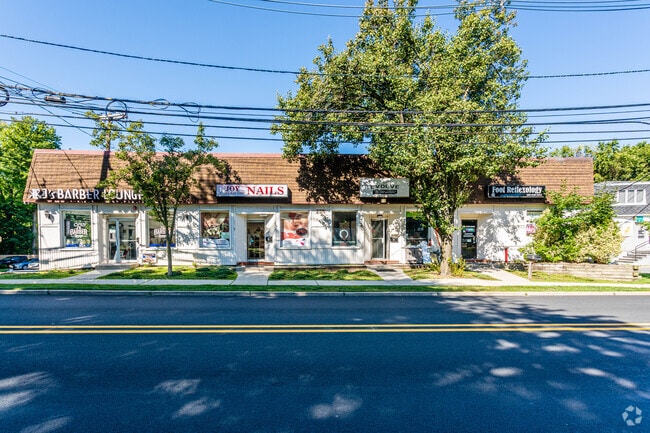

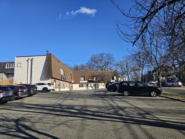

Property Detail
23 N Farview Ave
46-01213-0000-00010
.67 AC L.11
Commercialnec
Bergen
BN
New Jersey
B and X Area of moderate flood hazard, usually the area between the limits of the 100-year and 500-year floods.
10
2024
0.67 AC
2025
Route 4/17
042500
Northern New Jersey
11,808 SF
New York-Jersey City-White Plains, NY-NJ
NEARBY LISTINGS FOR SALE OR LEASE
DEMOGRAPHICS near 23 N Farview Ave
1 mile
3 mile
5 mile
2024 Total Population
9,908
169,036
583,212
2029 Population
10,256
174,194
594,939
Pop Growth 2024-2029
+ 3.51%
+ 3.05%
+ 2.01%
Average Age
44
42
40
2024 Total Households
3,438
62,697
202,532
HH Growth 2024-2029
+ 3.49%
+ 3.18%
+ 2.08%
Median Household Inc
$130,072
$110,831
$99,696
Avg Household Size
2.80
2.60
2.80
2024 Avg HH Vehicles
2.00
2.00
2.00
Median Home Value
$670,619
$594,705
$560,599
Median Year Built
1959
1958
1954
Nearby Places
Map Layers
Map Styles
 Street
 Aerial
Transit
 Traffic
 Biking
Places
Listings with unknown addresses are not visible on the map
- Restaurants
- Banks
- Shops
- Fitness
- Groceries
PUBLIC TRANSPORTATION
COMMUTER RAIL
New Bridge Landing (Pascack Valley Line - NJ Transit Commuter Rail (NJ Transit))
Drive
Walk
Distance
New Bridge Landing (Pascack Valley Line - NJ Transit Commuter Rail (NJ Transit))
5 min
2.6 mi
Anderson Street (Pascack Valley Line - NJ Transit Commuter Rail (NJ Transit))
Drive
Walk
Distance
Anderson Street (Pascack Valley Line - NJ Transit Commuter Rail (NJ Transit))
7 min
2.9 mi
AIRPORT
LaGuardia
Drive
Walk
Distance
LaGuardia
31 min
19.1 mi
Newark Liberty International
Drive
Walk
Distance
Newark Liberty International
25 min
19.5 mi
Westchester County
Drive
Walk
Distance
Westchester County
51 min
37.1 mi
Freight Ports
Maher Terminal
Drive
Walk
Distance
Maher Terminal
33 min
21.7 mi
SALE & LEASE HISTORY
LISTING DATE
SALE/LEASE

Oct 05, 2017
For Lease
May 22, 2019
For Lease
Mar 14, 2025
For Sale
Feb 11, 2020
For Lease
Nearby Properties
Address
Land Use
TOTAL SIZE
Lot Size
Zoning
Address
Land Use
TOTAL SIZE
Lot Size
Zoning
488,779 SF
7.55 AC
HCS
Address
Land Use
TOTAL SIZE
Lot Size
Zoning
1,267 SF
0.14 AC
BML
Address
Land Use
TOTAL SIZE
Lot Size
Zoning
Address
Land Use
TOTAL SIZE
Lot Size
Zoning
988,414 SF
34.89 AC
BG
Address
Land Use
TOTAL SIZE
Lot Size
Zoning
466,866 SF
154.93 AC
R150
Address
Land Use
TOTAL SIZE
Lot Size
Zoning
4.37 AC
HCS
Address
Land Use
TOTAL SIZE
Lot Size
Zoning
62.88 AC
R100
Address
Land Use
TOTAL SIZE
Lot Size
Zoning
378,400 SF
39.30 AC
BML
Address
Land Use
TOTAL SIZE
Lot Size
Zoning
512,862 SF
14.16 AC
Address
Land Use
TOTAL SIZE
Lot Size
Zoning
281,720 SF
3.93 AC
R-3
Address
Land Use
TOTAL SIZE
Lot Size
Zoning
102,070 SF
29.70 AC
BL
Address
Land Use
TOTAL SIZE
Lot Size
Zoning
160,036 SF
21.93 AC
R75
Address
Land Use
TOTAL SIZE
Lot Size
Zoning
7,060 SF
115.84 AC
HP
Address
Land Use
TOTAL SIZE
Lot Size
Zoning
8.66 AC
CH1
Address
Land Use
TOTAL SIZE
Lot Size
Zoning
232,368 SF
5.10 AC
Address
Land Use
TOTAL SIZE
Lot Size
Zoning
394,039 SF
24.31 AC
BG
Address
Land Use
TOTAL SIZE
Lot Size
Zoning
25,620 SF
21.37 AC
Address
Land Use
TOTAL SIZE
Lot Size
Zoning
197,742 SF
6.20 AC
R3
Address
Land Use
TOTAL SIZE
Lot Size
Zoning
164,588 SF
14.60 AC
BG
Address
Land Use
TOTAL SIZE
Lot Size
Zoning
250,833 SF
13.49 AC
BG
Address
Land Use
TOTAL SIZE
Lot Size
Zoning
341,076 SF
40.02 AC
R100
Address
Land Use
TOTAL SIZE
Lot Size
Zoning
303,434 SF
13.34 AC
Address
Land Use
TOTAL SIZE
Lot Size
Zoning
Address
Land Use
TOTAL SIZE
Lot Size
Zoning
259,273 SF
19.77 AC
BIL
Address
Land Use
TOTAL SIZE
Lot Size
Zoning
394,046 SF
1.88 AC
R3
Address
Land Use
TOTAL SIZE
Lot Size
Zoning
2,191 SF
1.34 AC
B2
Address
Land Use
TOTAL SIZE
Lot Size
Zoning
12,268 SF
98 AC
CR
Address
Land Use
TOTAL SIZE
Lot Size
Zoning
31,896 SF
1.64 AC
O
Address
Land Use
TOTAL SIZE
Lot Size
Zoning
5.53 AC
RS
Address
Land Use
TOTAL SIZE
Lot Size
Zoning
431,600 SF
2.70 AC
R3
The World's #1 Commercial Real Estate Marketplace
Connect with us
© 2026 CoStar Group
The information above has been obtained from sources believed reliable. While we do not doubt its accuracy we have not verified it and make no guarantee, warranty or representation about it. It is your responsibility to independently confirm its accuracy and completeness. Any projections, opinions, assumptions, or estimates used are for example only and do not represent the current or future performance of the property. The value of this transaction to you depends on tax and other factors which should be evaluated by your tax, financial, and legal advisors. You and your advisors should conduct a careful, independent investigation of the property to determine to your satisfaction the suitability of the property for your needs.