Property Record
23 Nickerson Rd, Ashland, MA 01721
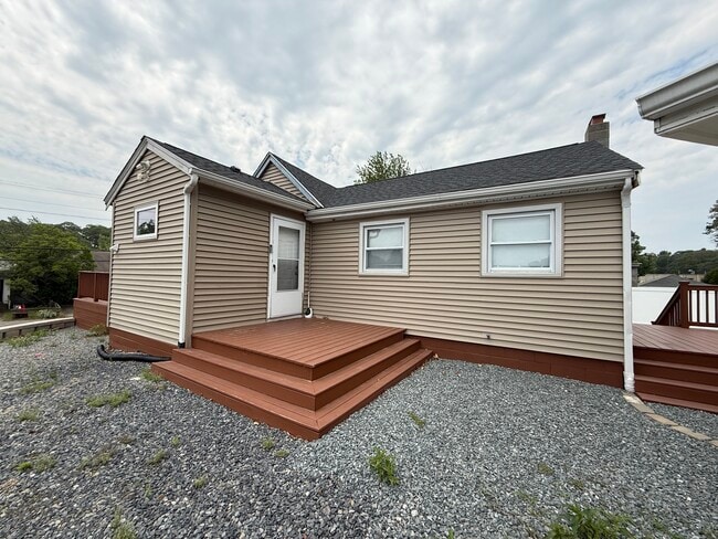
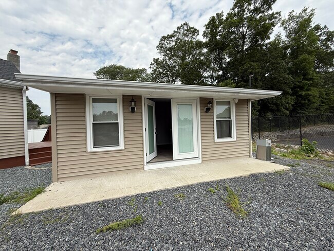
This Property Is For Sale
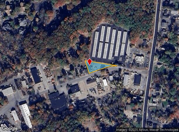
NEARBY LISTINGS FOR SALE OR LEASE
Property Detail
23 Nickerson Rd
Boston-Cambridge-Newton, MA-NH
Middlesex
ASHL-000026-000004
Massachusetts
Sfr
0.42 AC
X
Hopkinton/Holliston
25017C0631G
Boston
910 SF
DEMOGRAPHICS near 23 Nickerson Rd
1 Mile
3 Mile
5 Mile
2024 Total Population
6,354
50,204
124,531
2029 Population
6,379
50,737
125,651
Pop Growth 2024-2029
+ 0.39%
+ 1.06%
+ 0.90%
Average Age
43
40
40
2024 Total Households
2,564
18,408
47,270
HH Growth 2024-2029
+ 0.31%
+ 1.08%
+ 0.88%
Median Household Inc
$123,642
$103,872
$117,900
Avg Household Size
2.40
2.60
2.50
2024 Avg HH Vehicles
2.00
2.00
2.00
Median Home Value
$587,209
$681,428
$717,875
Median Year Built
1984
1969
1971
Nearby Places
- Restaurants
- Banks
- Shops
- Fitness
- Groceries
PUBLIC TRANSPORTATION
COMMUTER RAIL
Framingham Amtrak (Lake Shore Limited - Amtrak)
DRIVE
WALK
Distance
Framingham Amtrak (Lake Shore Limited - Amtrak)
5 min
2.5 mi
Framingham (Framingham/Worcester Line - Massachusetts Bay Transportation Authority Commuter Rail (Purple Line))
DRIVE
WALK
Distance
Framingham (Framingham/Worcester Line - Massachusetts Bay Transportation Authority Commuter Rail (Purple Line))
4 min
2.5 mi
AIRPORT
Worcester Regional
DRIVE
WALK
Distance
Worcester Regional
48 min
27.0 mi
General Edward Lawrence Logan International
DRIVE
WALK
Distance
General Edward Lawrence Logan International
42 min
27.3 mi
Freight Ports
Port of Boston
DRIVE
WALK
Distance
Port of Boston
41 min
25.7 mi
Nearby Properties
Address
Land Use
TOTAL SIZE
Lot Size
Zoning
Address
Land Use
TOTAL SIZE
Lot Size
Zoning
556,849 SF
28.44 AC
R4
Address
Land Use
TOTAL SIZE
Lot Size
Zoning
315,055 SF
40.38 AC
G
Address
Land Use
TOTAL SIZE
Lot Size
Zoning
244,033 SF
25.75 AC
R1
Address
Land Use
TOTAL SIZE
Lot Size
Zoning
108.84 AC
M
Address
Land Use
TOTAL SIZE
Lot Size
Zoning
372,275 SF
3.05 AC
CB
Address
Land Use
TOTAL SIZE
Lot Size
Zoning
139,356 SF
52 AC
30
Address
Land Use
TOTAL SIZE
Lot Size
Zoning
251,366 SF
14.42 AC
G
Address
Land Use
TOTAL SIZE
Lot Size
Zoning
3.02 AC
CB
Address
Land Use
TOTAL SIZE
Lot Size
Zoning
112,000 SF
18.48 AC
R1
Address
Land Use
TOTAL SIZE
Lot Size
Zoning
150,636 SF
30.34 AC
GE
Address
Land Use
TOTAL SIZE
Lot Size
Zoning
140,695 SF
2.52 AC
G
Address
Land Use
TOTAL SIZE
Lot Size
Zoning
154,724 SF
39.70 AC
G
Address
Land Use
TOTAL SIZE
Lot Size
Zoning
39,840 SF
17.20 AC
G
Address
Land Use
TOTAL SIZE
Lot Size
Zoning
61,866 SF
9.40 AC
G
Address
Land Use
TOTAL SIZE
Lot Size
Zoning
117,332 SF
3.02 AC
CB
Address
Land Use
TOTAL SIZE
Lot Size
Zoning
35,080 SF
8.29 AC
G
Address
Land Use
TOTAL SIZE
Lot Size
Zoning
42,000 SF
3.82 AC
30
Address
Land Use
TOTAL SIZE
Lot Size
Zoning
354,237 SF
7.16 AC
P
Address
Land Use
TOTAL SIZE
Lot Size
Zoning
70,457 SF
0.26 AC
CB
Address
Land Use
TOTAL SIZE
Lot Size
Zoning
75,224 SF
4.05 AC
I
Address
Land Use
TOTAL SIZE
Lot Size
Zoning
90,256 SF
14.48 AC
R4
Address
Land Use
TOTAL SIZE
Lot Size
Zoning
226,884 SF
6.16 AC
WMUSD
Address
Land Use
TOTAL SIZE
Lot Size
Zoning
67,708 SF
6.09 AC
M
Address
Land Use
TOTAL SIZE
Lot Size
Zoning
169,461 SF
32.30 AC
40
Address
Land Use
TOTAL SIZE
Lot Size
Zoning
71,070 SF
1.66 AC
R4
Address
Land Use
TOTAL SIZE
Lot Size
Zoning
85,380 SF
15.02 AC
R4
Address
Land Use
TOTAL SIZE
Lot Size
Zoning
237,660 SF
20.98 AC
I
Address
Land Use
TOTAL SIZE
Lot Size
Zoning
71,500 SF
3.40 AC
30
Address
Land Use
TOTAL SIZE
Lot Size
Zoning
134.63 AC
A
Address
Land Use
TOTAL SIZE
Lot Size
Zoning
40,000 SF
26.63 AC
30
The World's #1 Commercial Real Estate Marketplace
Connect with us
© 2025 CoStar Group
The information above has been obtained from sources believed reliable. While we do not doubt its accuracy we have not verified it and make no guarantee, warranty or representation about it. It is your responsibility to independently confirm its accuracy and completeness. Any projections, opinions, assumptions, or estimates used are for example only and do not represent the current or future performance of the property. The value of this transaction to you depends on tax and other factors which should be evaluated by your tax, financial, and legal advisors. You and your advisors should conduct a careful, independent investigation of the property to determine to your satisfaction the suitability of the property for your needs.