Property Record
23 Oceanic Ave, Staten Island, NY 10312
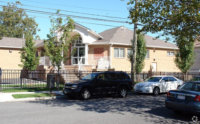

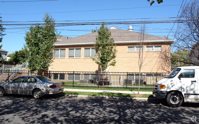
Property Detail
23 Oceanic Ave
05321-0095
Richmond
Funeralhome
New York
R3-1
95
B and X Area of moderate flood hazard, usually the area between the limits of the 100-year and 500-year floods.
0.26 AC
2024
Staten Island
2025
Long Island (New York)
015603
New York-Jersey City-White Plains, NY-NJ
8,946 SF
NEARBY LISTINGS FOR SALE OR LEASE
DEMOGRAPHICS near 23 Oceanic Ave
1 mile
3 mile
5 mile
2025 Total Population
19,189
127,382
253,979
2030 Population
19,406
128,109
255,580
Pop Growth 2025-2030
+ 1.13%
+ 0.57%
+ 0.63%
Average Age
43
43
42
2025 Total Households
6,891
45,691
90,118
HH Growth 2025-2030
+ 1.07%
+ 0.52%
+ 0.60%
Median Household Inc
$124,709
$113,802
$108,317
Avg Household Size
2.70
2.70
2.80
2025 Avg HH Vehicles
2.00
2.00
2.00
Median Home Value
$762,817
$741,253
$734,909
Median Year Built
1970
1976
1978
Nearby Places
Map Layers
Map Styles
 Street
 Aerial
Transit
 Traffic
 Biking
Places
Listings with unknown addresses are not visible on the map
- Restaurants
- Banks
- Shops
- Fitness
- Groceries
PUBLIC TRANSPORTATION
TRANSIT/SUBWAY
Eltingville (Staten Island Railway - New York MTA Subway (The Subway))
Drive
Walk
Distance
Eltingville (Staten Island Railway - New York MTA Subway (The Subway))
3 min
20 min
1.0 mi
COMMUTER RAIL
Eltingville (Staten Island Railway - New York MTA Subway (The Subway))
Drive
Walk
Distance
Eltingville (Staten Island Railway - New York MTA Subway (The Subway))
3 min
20 min
1.0 mi
Great Kills (Staten Island Railway - New York MTA Subway (The Subway))
Drive
Walk
Distance
Great Kills (Staten Island Railway - New York MTA Subway (The Subway))
4 min
1.4 mi
AIRPORT
Newark Liberty International
Drive
Walk
Distance
Newark Liberty International
33 min
18.0 mi
LaGuardia
Drive
Walk
Distance
LaGuardia
52 min
26.5 mi
John F Kennedy International
Drive
Walk
Distance
John F Kennedy International
55 min
29.0 mi
Freight Ports
New York Container Terminal
Drive
Walk
Distance
New York Container Terminal
20 min
8.4 mi
Nearby Properties
Address
Land Use
TOTAL SIZE
Lot Size
Zoning
Address
Land Use
TOTAL SIZE
Lot Size
Zoning
3,600 SF
731.18 AC
PARK
Address
Land Use
TOTAL SIZE
Lot Size
Zoning
237 AC
M1-1
Address
Land Use
TOTAL SIZE
Lot Size
Zoning
146 AC
PARK
Address
Land Use
TOTAL SIZE
Lot Size
Zoning
411,000 SF
18.54 AC
R3X
Address
Land Use
TOTAL SIZE
Lot Size
Zoning
11,140 SF
170.60 AC
PARK
Address
Land Use
TOTAL SIZE
Lot Size
Zoning
220,240 SF
5.77 AC
R3X
Address
Land Use
TOTAL SIZE
Lot Size
Zoning
294,320 SF
15 AC
R3-2
Address
Land Use
TOTAL SIZE
Lot Size
Zoning
505,000 SF
3.79 AC
R3A
Address
Land Use
TOTAL SIZE
Lot Size
Zoning
33.36 AC
PARK
Address
Land Use
TOTAL SIZE
Lot Size
Zoning
28.97 AC
PARK
Address
Land Use
TOTAL SIZE
Lot Size
Zoning
26.08 AC
PARK
Address
Land Use
TOTAL SIZE
Lot Size
Zoning
192,000 SF
5.47 AC
R3X
Address
Land Use
TOTAL SIZE
Lot Size
Zoning
188,692 SF
9.66 AC
R3-2
Address
Land Use
TOTAL SIZE
Lot Size
Zoning
26.45 AC
PARK
Address
Land Use
TOTAL SIZE
Lot Size
Zoning
180,000 SF
2.28 AC
R2
Address
Land Use
TOTAL SIZE
Lot Size
Zoning
27.90 AC
R3X
Address
Land Use
TOTAL SIZE
Lot Size
Zoning
24,000 SF
7.46 AC
C8-1
Address
Land Use
TOTAL SIZE
Lot Size
Zoning
2,750 SF
53.95 AC
R3-2
Address
Land Use
TOTAL SIZE
Lot Size
Zoning
100,780 SF
3.60 AC
R1-2
Address
Land Use
TOTAL SIZE
Lot Size
Zoning
156,000 SF
5.20 AC
R3-1
Address
Land Use
TOTAL SIZE
Lot Size
Zoning
79,000 SF
4.88 AC
R2
Address
Land Use
TOTAL SIZE
Lot Size
Zoning
102,323 SF
2.76 AC
R3-2
Address
Land Use
TOTAL SIZE
Lot Size
Zoning
5,218 SF
50.51 AC
PARK
Address
Land Use
TOTAL SIZE
Lot Size
Zoning
14.92 AC
PARK
Address
Land Use
TOTAL SIZE
Lot Size
Zoning
65,476 SF
2.48 AC
R3-2
Address
Land Use
TOTAL SIZE
Lot Size
Zoning
125,000 SF
2.28 AC
R3-1
Address
Land Use
TOTAL SIZE
Lot Size
Zoning
77,582 SF
3.78 AC
C4-1
Address
Land Use
TOTAL SIZE
Lot Size
Zoning
366,642 SF
6.64 AC
C4-1
Address
Land Use
TOTAL SIZE
Lot Size
Zoning
66,484 SF
9.15 AC
R3X
Address
Land Use
TOTAL SIZE
Lot Size
Zoning
103,868 SF
11.05 AC
C4-1
The World's #1 Commercial Real Estate Marketplace
Connect with us
© 2026 CoStar Group
The information above has been obtained from sources believed reliable. While we do not doubt its accuracy we have not verified it and make no guarantee, warranty or representation about it. It is your responsibility to independently confirm its accuracy and completeness. Any projections, opinions, assumptions, or estimates used are for example only and do not represent the current or future performance of the property. The value of this transaction to you depends on tax and other factors which should be evaluated by your tax, financial, and legal advisors. You and your advisors should conduct a careful, independent investigation of the property to determine to your satisfaction the suitability of the property for your needs.