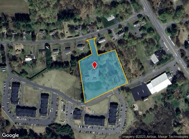
Property Record
23 Plumtree Rd, Sunderland, MA 01375
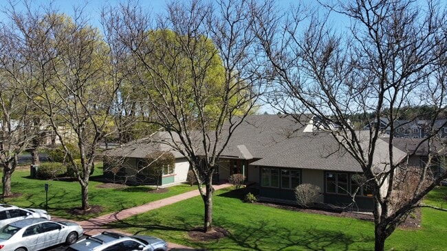
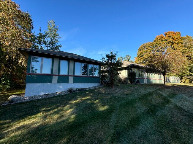
This Property Is For Sale
NEARBY LISTINGS FOR SALE OR LEASE
-
-
View all Sunderland listings for sale on LoopNet.com
Property Detail
23 Plumtree Rd
Greenfield Town, MA
Franklin
SUND-000013-000000-000079
Massachusetts
Officebuilding
79
2025
3.47 AC
2025
Franklin County
040800
Hartford
10,647 SF
DEMOGRAPHICS near 23 Plumtree Rd
1 Mile
3 Mile
5 Mile
2024 Total Population
730
11,041
42,375
2029 Population
686
9,661
38,218
Pop Growth 2024-2029
(6.03%)
(12.50%)
(9.81%)
Average Age
42
38
33
2024 Total Households
310
4,490
11,377
HH Growth 2024-2029
(6.13%)
(12.32%)
(14.69%)
Median Household Inc
$97,669
$67,883
$71,237
Avg Household Size
2.30
2.30
2.20
2024 Avg HH Vehicles
2.00
2.00
2.00
Median Home Value
$390,713
$415,000
$402,708
Median Year Built
1981
1977
1972
Nearby Places
Map Layers
Map Styles
 Street
 Aerial
- Restaurants
- Banks
- Shops
- Fitness
- Groceries
Nearby Properties
Address
Land Use
TOTAL SIZE
Lot Size
Zoning
Address
Land Use
TOTAL SIZE
Lot Size
Zoning
1,344 SF
284.31 AC
Address
Land Use
TOTAL SIZE
Lot Size
Zoning
168,500 SF
18.25 AC
C+I
Address
Land Use
TOTAL SIZE
Lot Size
Zoning
28.93 AC
C1WD
Address
Land Use
TOTAL SIZE
Lot Size
Zoning
23,690 SF
13.98 AC
Address
Land Use
TOTAL SIZE
Lot Size
Zoning
10,248 SF
26.17 AC
Address
Land Use
TOTAL SIZE
Lot Size
Zoning
13,426 SF
16 AC
Address
Land Use
TOTAL SIZE
Lot Size
Zoning
31.73 AC
Address
Land Use
TOTAL SIZE
Lot Size
Zoning
9.12 AC
VR
Address
Land Use
TOTAL SIZE
Lot Size
Zoning
5.93 AC
VR
Address
Land Use
TOTAL SIZE
Lot Size
Zoning
9.65 AC
C+I
Address
Land Use
TOTAL SIZE
Lot Size
Zoning
74,959 SF
Address
Land Use
TOTAL SIZE
Lot Size
Zoning
10,080 SF
0.61 AC
Address
Land Use
TOTAL SIZE
Lot Size
Zoning
10,584 SF
7.17 AC
Address
Land Use
TOTAL SIZE
Lot Size
Zoning
4.99 AC
C+I
Address
Land Use
TOTAL SIZE
Lot Size
Zoning
6,768 SF
6.53 AC
Address
Land Use
TOTAL SIZE
Lot Size
Zoning
42,903 SF
22.73 AC
C+I
Address
Land Use
TOTAL SIZE
Lot Size
Zoning
3,692 SF
2.51 AC
Address
Land Use
TOTAL SIZE
Lot Size
Zoning
99,595 SF
47 AC
R4
Address
Land Use
TOTAL SIZE
Lot Size
Zoning
1,476 SF
43.50 AC
RRWD
Address
Land Use
TOTAL SIZE
Lot Size
Zoning
4,391 SF
12.40 AC
Address
Land Use
TOTAL SIZE
Lot Size
Zoning
990 SF
RRPA
Address
Land Use
TOTAL SIZE
Lot Size
Zoning
13,664 SF
5 AC
Address
Land Use
TOTAL SIZE
Lot Size
Zoning
11,653 SF
5.54 AC
Address
Land Use
TOTAL SIZE
Lot Size
Zoning
18,569 SF
Address
Land Use
TOTAL SIZE
Lot Size
Zoning
5,346 SF
9.50 AC
LB
Address
Land Use
TOTAL SIZE
Lot Size
Zoning
2.51 AC
RRPA
Address
Land Use
TOTAL SIZE
Lot Size
Zoning
12,584 SF
3.85 AC
Address
Land Use
TOTAL SIZE
Lot Size
Zoning
7,672 SF
2.83 AC
Address
Land Use
TOTAL SIZE
Lot Size
Zoning
5,046 SF
2.50 AC
Address
Land Use
TOTAL SIZE
Lot Size
Zoning
19.67 AC
RR
The World's #1 Commercial Real Estate Marketplace
Connect with us
© 2025 CoStar Group
The information above has been obtained from sources believed reliable. While we do not doubt its accuracy we have not verified it and make no guarantee, warranty or representation about it. It is your responsibility to independently confirm its accuracy and completeness. Any projections, opinions, assumptions, or estimates used are for example only and do not represent the current or future performance of the property. The value of this transaction to you depends on tax and other factors which should be evaluated by your tax, financial, and legal advisors. You and your advisors should conduct a careful, independent investigation of the property to determine to your satisfaction the suitability of the property for your needs.