Property Record
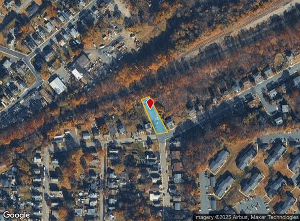
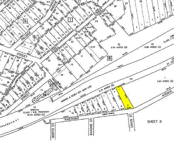
23 Railroad Ave, Netcong, NJ 07857

NEARBY LISTINGS FOR SALE OR LEASE
Property Detail
23 Railroad Ave
Newark, NJ-PA
Morris
28-00008-0000-00002
New Jersey
Commercialnec
2
2024
0.26 AC
2025
Route 80 Corridor
046000
Northern New Jersey
4,752 SF
DEMOGRAPHICS near 23 Railroad Ave
1 Mile
3 Mile
5 Mile
2024 Total Population
5,872
39,224
81,127
2029 Population
5,903
39,537
81,525
Pop Growth 2024-2029
+ 0.53%
+ 0.80%
+ 0.49%
Average Age
41
42
42
2024 Total Households
2,339
15,645
31,512
HH Growth 2024-2029
+ 0.64%
+ 0.72%
+ 0.44%
Median Household Inc
$72,836
$97,238
$100,851
Avg Household Size
2.40
2.40
2.50
2024 Avg HH Vehicles
2.00
2.00
2.00
Median Home Value
$318,307
$334,209
$357,317
Median Year Built
1959
1973
1971
Nearby Places
Map Layers
Map Styles
 Street
 Aerial
- Restaurants
- Banks
- Shops
- Fitness
- Groceries
PUBLIC TRANSPORTATION
COMMUTER RAIL
Netcong (Montclair-Boonton Line - NJ Transit Commuter Rail (NJ Transit), Morris & Essex Morristown Line - NJ Transit Commuter Rail (NJ Transit))
DRIVE
WALK
Distance
Netcong (Montclair-Boonton Line - NJ Transit Commuter Rail (NJ Transit), Morris & Essex Morristown Line - NJ Transit Commuter Rail (NJ Transit))
2 min
17 min
0.9 mi
Lake Hopatcong (Montclair-Boonton Line - NJ Transit Commuter Rail (NJ Transit), Morris & Essex Morristown Line - NJ Transit Commuter Rail (NJ Transit))
DRIVE
WALK
Distance
Lake Hopatcong (Montclair-Boonton Line - NJ Transit Commuter Rail (NJ Transit), Morris & Essex Morristown Line - NJ Transit Commuter Rail (NJ Transit))
7 min
3.6 mi
Freight Ports
Maher Terminal
DRIVE
WALK
Distance
Maher Terminal
51 min
38.6 mi
Nearby Properties
Address
Land Use
TOTAL SIZE
Lot Size
Zoning
Address
Land Use
TOTAL SIZE
Lot Size
Zoning
114.47 AC
C-1
Address
Land Use
TOTAL SIZE
Lot Size
Zoning
977,550 SF
97.50 AC
FTZ4
Address
Land Use
TOTAL SIZE
Lot Size
Zoning
56.90 AC
Address
Land Use
TOTAL SIZE
Lot Size
Zoning
280,960 SF
46.25 AC
R-4
Address
Land Use
TOTAL SIZE
Lot Size
Zoning
44.67 AC
R2
Address
Land Use
TOTAL SIZE
Lot Size
Zoning
72.81 AC
LIOR
Address
Land Use
TOTAL SIZE
Lot Size
Zoning
350,000 SF
49.35 AC
P
Address
Land Use
TOTAL SIZE
Lot Size
Zoning
412,816 SF
40.48 AC
FTZ2
Address
Land Use
TOTAL SIZE
Lot Size
Zoning
6.74 AC
TC
Address
Land Use
TOTAL SIZE
Lot Size
Zoning
48.48 AC
MLR
Address
Land Use
TOTAL SIZE
Lot Size
Zoning
5.19 AC
FTZ3
Address
Land Use
TOTAL SIZE
Lot Size
Zoning
136,928 SF
15.72 AC
C-LI
Address
Land Use
TOTAL SIZE
Lot Size
Zoning
126,875 SF
7.02 AC
Address
Land Use
TOTAL SIZE
Lot Size
Zoning
228 SF
30.95 AC
L-I
Address
Land Use
TOTAL SIZE
Lot Size
Zoning
55.26 AC
PUD
Address
Land Use
TOTAL SIZE
Lot Size
Zoning
11.13 AC
FTZ1
Address
Land Use
TOTAL SIZE
Lot Size
Zoning
249,480 SF
5.66 AC
FTZ1
Address
Land Use
TOTAL SIZE
Lot Size
Zoning
13.63 AC
FTZ4
Address
Land Use
TOTAL SIZE
Lot Size
Zoning
207,196 SF
13.94 AC
L-I
Address
Land Use
TOTAL SIZE
Lot Size
Zoning
102,512 SF
17 AC
C-LI
Address
Land Use
TOTAL SIZE
Lot Size
Zoning
185,975 SF
18.20 AC
FTZ2
Address
Land Use
TOTAL SIZE
Lot Size
Zoning
142,168 SF
14.84 AC
C-LI
Address
Land Use
TOTAL SIZE
Lot Size
Zoning
248,940 SF
22.06 AC
FTZ2
Address
Land Use
TOTAL SIZE
Lot Size
Zoning
220,912 SF
56.21 AC
FTZ1
Address
Land Use
TOTAL SIZE
Lot Size
Zoning
132,312 SF
12.13 AC
C-LI
Address
Land Use
TOTAL SIZE
Lot Size
Zoning
20.85 AC
I-3
Address
Land Use
TOTAL SIZE
Lot Size
Zoning
8.43 AC
B-3
Address
Land Use
TOTAL SIZE
Lot Size
Zoning
19.87 AC
VB
Address
Land Use
TOTAL SIZE
Lot Size
Zoning
68,844 SF
5 AC
PUD
Address
Land Use
TOTAL SIZE
Lot Size
Zoning
134,760 SF
14 AC
C-LI
The World's #1 Commercial Real Estate Marketplace
Connect with us
© 2025 CoStar Group
The information above has been obtained from sources believed reliable. While we do not doubt its accuracy we have not verified it and make no guarantee, warranty or representation about it. It is your responsibility to independently confirm its accuracy and completeness. Any projections, opinions, assumptions, or estimates used are for example only and do not represent the current or future performance of the property. The value of this transaction to you depends on tax and other factors which should be evaluated by your tax, financial, and legal advisors. You and your advisors should conduct a careful, independent investigation of the property to determine to your satisfaction the suitability of the property for your needs.