Property Record
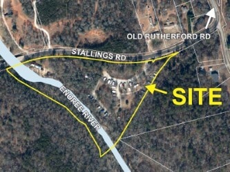
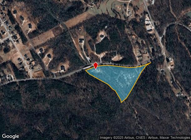
23 Stallings Rd, Taylors, SC 29687
NEARBY LISTINGS FOR SALE OR LEASE
Property Detail
23 Stallings Rd
Greenville-Anderson-Mauldin, SC
Property Of W H And Mittied F Langley
T025.00-01-006.00
MAP T025.00; 5
Agriculturalland
Greenville
AE
South Carolina
45045C0329E
006.00
2025
11.30 AC
2024
Greer/Taylors
002611
Greenville/Spartanburg
1,584 SF
DEMOGRAPHICS near 23 Stallings Rd
1 Mile
3 Mile
5 Mile
2024 Total Population
3,629
33,966
100,342
2029 Population
3,958
36,780
108,949
Pop Growth 2024-2029
+ 9.07%
+ 8.28%
+ 8.58%
Average Age
39
41
41
2024 Total Households
1,503
13,361
39,842
HH Growth 2024-2029
+ 9.05%
+ 8.32%
+ 8.61%
Median Household Inc
$56,874
$69,533
$73,227
Avg Household Size
2.40
2.50
2.50
2024 Avg HH Vehicles
2.00
2.00
2.00
Median Home Value
$214,688
$234,975
$251,466
Median Year Built
1985
1986
1987
Nearby Places
Map Layers
Map Styles
 Street
 Aerial
- Restaurants
- Banks
- Shops
- Fitness
- Groceries
PUBLIC TRANSPORTATION
COMMUTER RAIL
Greenville Amtrak Station (Crescent - Amtrak)
DRIVE
WALK
Distance
Greenville Amtrak Station (Crescent - Amtrak)
17 min
9.0 mi
AIRPORT
Greenville Spartanburg International
DRIVE
WALK
Distance
Greenville Spartanburg International
25 min
11.4 mi
Freight Ports
North Charleston Terminal
DRIVE
WALK
Distance
North Charleston Terminal
239 min
209.0 mi
SALE & LEASE HISTORY
LISTING DATE
SALE/LEASE

Dec 20, 2024
For Sale
Nearby Properties
Address
Land Use
TOTAL SIZE
Lot Size
Zoning
Address
Land Use
TOTAL SIZE
Lot Size
Zoning
11.80 AC
R10
Address
Land Use
TOTAL SIZE
Lot Size
Zoning
11.30 AC
R10
Address
Land Use
TOTAL SIZE
Lot Size
Zoning
25.70 AC
R20
Address
Land Use
TOTAL SIZE
Lot Size
Zoning
8.95 AC
OD
Address
Land Use
TOTAL SIZE
Lot Size
Zoning
41.90 AC
RMA
Address
Land Use
TOTAL SIZE
Lot Size
Zoning
1.20 AC
I1
Address
Land Use
TOTAL SIZE
Lot Size
Zoning
8.10 AC
I1
Address
Land Use
TOTAL SIZE
Lot Size
Zoning
1.03 AC
RM
Address
Land Use
TOTAL SIZE
Lot Size
Zoning
82.10 AC
S1
Address
Land Use
TOTAL SIZE
Lot Size
Zoning
14.78 AC
I1
Address
Land Use
TOTAL SIZE
Lot Size
Zoning
9.14 AC
R75
Address
Land Use
TOTAL SIZE
Lot Size
Zoning
3.11 AC
I1
Address
Land Use
TOTAL SIZE
Lot Size
Zoning
12 AC
RM
Address
Land Use
TOTAL SIZE
Lot Size
Zoning
12.30 AC
I1
Address
Land Use
TOTAL SIZE
Lot Size
Zoning
1.70 AC
R75
Address
Land Use
TOTAL SIZE
Lot Size
Zoning
17.32 AC
C3
Address
Land Use
TOTAL SIZE
Lot Size
Zoning
2,194 SF
56.43 AC
S1
Address
Land Use
TOTAL SIZE
Lot Size
Zoning
5.05 AC
C2
Address
Land Use
TOTAL SIZE
Lot Size
Zoning
20.63 AC
C2
Address
Land Use
TOTAL SIZE
Lot Size
Zoning
11 AC
RM
Address
Land Use
TOTAL SIZE
Lot Size
Zoning
1.93 AC
R20
Address
Land Use
TOTAL SIZE
Lot Size
Zoning
17.22 AC
I1
Address
Land Use
TOTAL SIZE
Lot Size
Zoning
3.60 AC
R20
Address
Land Use
TOTAL SIZE
Lot Size
Zoning
10 AC
I1
Address
Land Use
TOTAL SIZE
Lot Size
Zoning
12.47 AC
C3
Address
Land Use
TOTAL SIZE
Lot Size
Zoning
3.65 AC
PDR
Address
Land Use
TOTAL SIZE
Lot Size
Zoning
3.10 AC
C2
Address
Land Use
TOTAL SIZE
Lot Size
Zoning
43.20 AC
UNZONED
Address
Land Use
TOTAL SIZE
Lot Size
Zoning
2.14 AC
C2
Address
Land Use
TOTAL SIZE
Lot Size
Zoning
1,390 SF
4.50 AC
UNZONED
The World's #1 Commercial Real Estate Marketplace
Connect with us
© 2025 CoStar Group
The information above has been obtained from sources believed reliable. While we do not doubt its accuracy we have not verified it and make no guarantee, warranty or representation about it. It is your responsibility to independently confirm its accuracy and completeness. Any projections, opinions, assumptions, or estimates used are for example only and do not represent the current or future performance of the property. The value of this transaction to you depends on tax and other factors which should be evaluated by your tax, financial, and legal advisors. You and your advisors should conduct a careful, independent investigation of the property to determine to your satisfaction the suitability of the property for your needs.