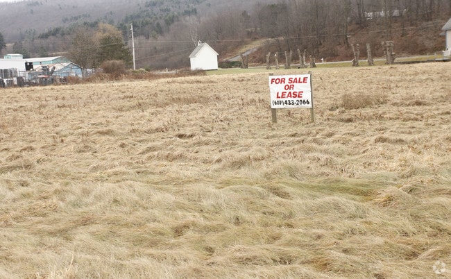
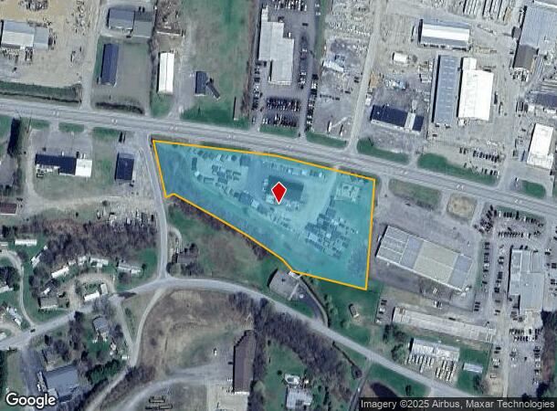
Property Record
23 State Highway 23 St, Oneonta, NY 13820
NEARBY LISTINGS FOR SALE OR LEASE
Property Detail
23 State Highway 23 St
122600-021-000-0001-002-110
CHARLOTTE RP L-47 #2893 FM 6764
Storebuilding
Delaware
X
New York
36077C0659E
2.110
2025
4.30 AC
2024
New York Southeast Area
590900
Other Market Areas
5,000 SF
DEMOGRAPHICS near 23 State Highway 23 St
1 Mile
3 Mile
5 Mile
2024 Total Population
716
11,526
22,740
2029 Population
713
11,554
22,697
Pop Growth 2024-2029
(0.42%)
+ 0.24%
(0.19%)
Average Age
44
40
37
2024 Total Households
274
4,608
7,115
HH Growth 2024-2029
(0.36%)
0.00%
(0.32%)
Median Household Inc
$50,833
$58,411
$58,900
Avg Household Size
2.30
2.10
2.10
2024 Avg HH Vehicles
2.00
1.00
2.00
Median Home Value
$160,714
$162,578
$168,051
Median Year Built
1980
1949
1950
Nearby Places
Map Layers
Map Styles
 Street
 Aerial
- Restaurants
- Banks
- Shops
- Fitness
- Groceries
SALE & LEASE HISTORY
LISTING DATE
SALE/LEASE

Feb 12, 2019
For Sale
Nearby Properties
Address
Land Use
TOTAL SIZE
Lot Size
Zoning
Address
Land Use
TOTAL SIZE
Lot Size
Zoning
216,150 SF
3.04 AC
610
Address
Land Use
TOTAL SIZE
Lot Size
Zoning
456,905 SF
73.89 AC
620
Address
Land Use
TOTAL SIZE
Lot Size
Zoning
275,240 SF
28.08 AC
Address
Land Use
TOTAL SIZE
Lot Size
Zoning
141,104 SF
17.85 AC
01
Address
Land Use
TOTAL SIZE
Lot Size
Zoning
Address
Land Use
TOTAL SIZE
Lot Size
Zoning
179,626 SF
21.80 AC
01
Address
Land Use
TOTAL SIZE
Lot Size
Zoning
134,563 SF
33.59 AC
Address
Land Use
TOTAL SIZE
Lot Size
Zoning
55,551 SF
6 AC
Address
Land Use
TOTAL SIZE
Lot Size
Zoning
80,492 SF
9.32 AC
Address
Land Use
TOTAL SIZE
Lot Size
Zoning
71,504 SF
4.09 AC
Address
Land Use
TOTAL SIZE
Lot Size
Zoning
36,629 SF
2.11 AC
610
Address
Land Use
TOTAL SIZE
Lot Size
Zoning
83,256 SF
1.30 AC
620
Address
Land Use
TOTAL SIZE
Lot Size
Zoning
64,072 SF
1.53 AC
330
Address
Land Use
TOTAL SIZE
Lot Size
Zoning
67,224 SF
8.11 AC
Address
Land Use
TOTAL SIZE
Lot Size
Zoning
0.01 AC
Address
Land Use
TOTAL SIZE
Lot Size
Zoning
83,384 SF
10.45 AC
Address
Land Use
TOTAL SIZE
Lot Size
Zoning
53,900 SF
4.08 AC
Address
Land Use
TOTAL SIZE
Lot Size
Zoning
8,839 SF
15.16 AC
140
Address
Land Use
TOTAL SIZE
Lot Size
Zoning
73,580 SF
0.51 AC
310
Address
Land Use
TOTAL SIZE
Lot Size
Zoning
49,047 SF
11.37 AC
01
Address
Land Use
TOTAL SIZE
Lot Size
Zoning
142.46 AC
Address
Land Use
TOTAL SIZE
Lot Size
Zoning
67,528 SF
3.10 AC
620
Address
Land Use
TOTAL SIZE
Lot Size
Zoning
64,588 SF
8.64 AC
01
Address
Land Use
TOTAL SIZE
Lot Size
Zoning
37,536 SF
10.36 AC
620
Address
Land Use
TOTAL SIZE
Lot Size
Zoning
33,454 SF
1.55 AC
340
Address
Land Use
TOTAL SIZE
Lot Size
Zoning
44,500 SF
2.04 AC
352
Address
Land Use
TOTAL SIZE
Lot Size
Zoning
28,620 SF
1.80 AC
Address
Land Use
TOTAL SIZE
Lot Size
Zoning
1,617 SF
38.51 AC
Address
Land Use
TOTAL SIZE
Lot Size
Zoning
32,000 SF
5.85 AC
Address
Land Use
TOTAL SIZE
Lot Size
Zoning
61,316 SF
0.82 AC
310
The World's #1 Commercial Real Estate Marketplace
Connect with us
© 2026 CoStar Group
The information above has been obtained from sources believed reliable. While we do not doubt its accuracy we have not verified it and make no guarantee, warranty or representation about it. It is your responsibility to independently confirm its accuracy and completeness. Any projections, opinions, assumptions, or estimates used are for example only and do not represent the current or future performance of the property. The value of this transaction to you depends on tax and other factors which should be evaluated by your tax, financial, and legal advisors. You and your advisors should conduct a careful, independent investigation of the property to determine to your satisfaction the suitability of the property for your needs.