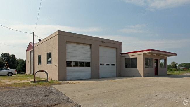
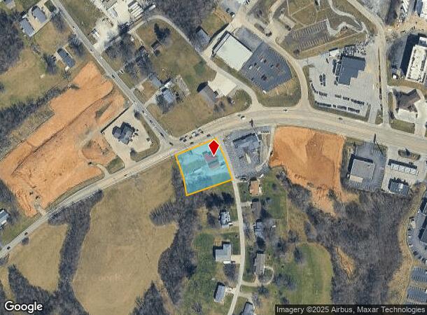
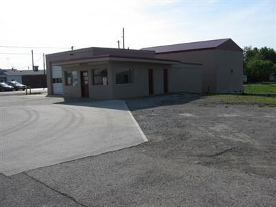
Property Record
23 Taft Hwy, Dry Ridge, KY 41035
NEARBY LISTINGS FOR SALE OR LEASE
Property Detail
23 Taft Hwy
Cincinnati, OH-KY-IN
Stith Sub
046-03-00-017.00
BLDG & WILORN LOT 1 & LOT 36 STITH SUB
Servicestation
Grant
X
Kentucky
21191C0125E
1-36
2025
1.08 AC
2025
Grant County
920201
Cincinnati/Dayton
2,200 SF
DEMOGRAPHICS near 23 Taft Hwy
1 Mile
3 Mile
5 Mile
2024 Total Population
1,462
5,882
12,986
2029 Population
1,533
6,245
13,827
Pop Growth 2024-2029
+ 4.86%
+ 6.17%
+ 6.48%
Average Age
39
38
38
2024 Total Households
549
2,127
4,641
HH Growth 2024-2029
+ 4.92%
+ 6.21%
+ 6.51%
Median Household Inc
$49,351
$59,570
$60,061
Avg Household Size
2.60
2.70
2.70
2024 Avg HH Vehicles
2.00
2.00
2.00
Median Home Value
$187,407
$181,850
$175,657
Median Year Built
1988
1988
1988
Nearby Places
Map Layers
Map Styles
 Street
 Aerial
- Restaurants
- Banks
- Shops
- Fitness
- Groceries
PUBLIC TRANSPORTATION
AIRPORT
Cincinnati/Northern Kentucky International
DRIVE
WALK
Distance
Cincinnati/Northern Kentucky International
39 min
28.0 mi
Freight Ports
Port of Toledo
DRIVE
WALK
Distance
Port of Toledo
281 min
240.1 mi
Nearby Properties
Address
Land Use
TOTAL SIZE
Lot Size
Zoning
Address
Land Use
TOTAL SIZE
Lot Size
Zoning
321,300 SF
28.87 AC
Address
Land Use
TOTAL SIZE
Lot Size
Zoning
154,743 SF
16.19 AC
COM
Address
Land Use
TOTAL SIZE
Lot Size
Zoning
Address
Land Use
TOTAL SIZE
Lot Size
Zoning
2,400 SF
0.70 AC
COM
Address
Land Use
TOTAL SIZE
Lot Size
Zoning
Address
Land Use
TOTAL SIZE
Lot Size
Zoning
7.62 AC
Address
Land Use
TOTAL SIZE
Lot Size
Zoning
31.95 AC
Address
Land Use
TOTAL SIZE
Lot Size
Zoning
39,548 SF
1.29 AC
COM
Address
Land Use
TOTAL SIZE
Lot Size
Zoning
10.81 AC
Address
Land Use
TOTAL SIZE
Lot Size
Zoning
21,420 SF
4.83 AC
Address
Land Use
TOTAL SIZE
Lot Size
Zoning
3,350 SF
1 AC
COM
Address
Land Use
TOTAL SIZE
Lot Size
Zoning
6,272 SF
5.75 AC
Address
Land Use
TOTAL SIZE
Lot Size
Zoning
Address
Land Use
TOTAL SIZE
Lot Size
Zoning
4,230 SF
0.84 AC
COM
Address
Land Use
TOTAL SIZE
Lot Size
Zoning
35,685 SF
1.32 AC
COM
Address
Land Use
TOTAL SIZE
Lot Size
Zoning
14,142 SF
3 AC
Address
Land Use
TOTAL SIZE
Lot Size
Zoning
5,100 SF
0.85 AC
Address
Land Use
TOTAL SIZE
Lot Size
Zoning
15.35 AC
Address
Land Use
TOTAL SIZE
Lot Size
Zoning
16,545 SF
3.34 AC
Address
Land Use
TOTAL SIZE
Lot Size
Zoning
33.67 AC
Address
Land Use
TOTAL SIZE
Lot Size
Zoning
22,152 SF
1.13 AC
COM
Address
Land Use
TOTAL SIZE
Lot Size
Zoning
38 AC
Address
Land Use
TOTAL SIZE
Lot Size
Zoning
127,735 SF
11.10 AC
Address
Land Use
TOTAL SIZE
Lot Size
Zoning
Address
Land Use
TOTAL SIZE
Lot Size
Zoning
11.20 AC
Address
Land Use
TOTAL SIZE
Lot Size
Zoning
1.40 AC
Address
Land Use
TOTAL SIZE
Lot Size
Zoning
1.43 AC
Address
Land Use
TOTAL SIZE
Lot Size
Zoning
5,850 SF
0.83 AC
Address
Land Use
TOTAL SIZE
Lot Size
Zoning
5,232 SF
2.50 AC
Address
Land Use
TOTAL SIZE
Lot Size
Zoning
8,540 SF
3.25 AC
COM
The World's #1 Commercial Real Estate Marketplace
Connect with us
© 2025 CoStar Group
The information above has been obtained from sources believed reliable. While we do not doubt its accuracy we have not verified it and make no guarantee, warranty or representation about it. It is your responsibility to independently confirm its accuracy and completeness. Any projections, opinions, assumptions, or estimates used are for example only and do not represent the current or future performance of the property. The value of this transaction to you depends on tax and other factors which should be evaluated by your tax, financial, and legal advisors. You and your advisors should conduct a careful, independent investigation of the property to determine to your satisfaction the suitability of the property for your needs.