Property Record
23 Ten Mile Dr, Granby, CO 80446
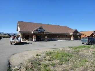


Property Detail
23 Ten Mile Dr
R304191
SUBD: SILVERCREEK WEST FIRST ADDN LOT: 4 BLOCK: 6 AMD
Officecondo
GRAND
20
Colorado
B and X Area of moderate flood hazard, usually the area between the limits of the 100-year and 500-year floods.
4
2025
0.85 AC
2025
Colorado Ski Area
000205
Other Market Areas
6,000 SF
NEARBY LISTINGS FOR SALE OR LEASE
DEMOGRAPHICS near 23 Ten Mile Dr
1 mile
3 mile
5 mile
2025 Total Population
1,807
4,737
5,170
2030 Population
1,834
5,052
5,500
Pop Growth 2025-2030
+ 1.49%
+ 6.65%
+ 6.38%
Average Age
42
42
43
2025 Total Households
717
1,977
2,163
HH Growth 2025-2030
+ 1.26%
+ 6.88%
+ 6.56%
Median Household Inc
$96,658
$94,929
$94,994
Avg Household Size
2.50
2.40
2.30
2025 Avg HH Vehicles
2.00
2.00
2.00
Median Home Value
$583,744
$697,791
$702,795
Median Year Built
1993
2000
1999
Nearby Places
Map Layers
Map Styles
 Street
 Aerial
Layers
 Traffic
 Biking
Places
Listings with unknown addresses are not visible on the map
- Restaurants
- Banks
- Shops
- Fitness
- Groceries
PUBLIC TRANSPORTATION
COMMUTER RAIL
Granby Amtrak Station (California Zephyr - Amtrak)
Drive
Walk
Distance
Granby Amtrak Station (California Zephyr - Amtrak)
2 min
17 min
0.9 mi
Freight Ports
Tulsa Port Of Catoosa
Drive
Walk
Distance
Tulsa Port Of Catoosa
850 min
794.5 mi
Nearby Properties
Address
Land Use
TOTAL SIZE
Lot Size
Zoning
Address
Land Use
TOTAL SIZE
Lot Size
Zoning
82,632 SF
10.22 AC
Address
Land Use
TOTAL SIZE
Lot Size
Zoning
121,034 SF
18.75 AC
Address
Land Use
TOTAL SIZE
Lot Size
Zoning
54,927 SF
5.47 AC
Address
Land Use
TOTAL SIZE
Lot Size
Zoning
57,618 SF
5.63 AC
Address
Land Use
TOTAL SIZE
Lot Size
Zoning
4,460 SF
2.38 AC
Address
Land Use
TOTAL SIZE
Lot Size
Zoning
22,476 SF
1.69 AC
20
Address
Land Use
TOTAL SIZE
Lot Size
Zoning
12,359 SF
3.55 AC
20
Address
Land Use
TOTAL SIZE
Lot Size
Zoning
20,463 SF
4.53 AC
Address
Land Use
TOTAL SIZE
Lot Size
Zoning
11,089 SF
0.79 AC
19
Address
Land Use
TOTAL SIZE
Lot Size
Zoning
17,748 SF
3.38 AC
20
Address
Land Use
TOTAL SIZE
Lot Size
Zoning
106.09 AC
18
Address
Land Use
TOTAL SIZE
Lot Size
Zoning
18,016 SF
1.95 AC
20
Address
Land Use
TOTAL SIZE
Lot Size
Zoning
20,879 SF
0.81 AC
20
Address
Land Use
TOTAL SIZE
Lot Size
Zoning
18,222 SF
1.45 AC
19
Address
Land Use
TOTAL SIZE
Lot Size
Zoning
3,840 SF
2.42 AC
43
Address
Land Use
TOTAL SIZE
Lot Size
Zoning
9,106 SF
1.01 AC
20
Address
Land Use
TOTAL SIZE
Lot Size
Zoning
9,128 SF
0.63 AC
19
Address
Land Use
TOTAL SIZE
Lot Size
Zoning
6,431 SF
0.85 AC
20
Address
Land Use
TOTAL SIZE
Lot Size
Zoning
5,340 SF
1.55 AC
20
Address
Land Use
TOTAL SIZE
Lot Size
Zoning
5,176 SF
0.57 AC
20
Address
Land Use
TOTAL SIZE
Lot Size
Zoning
4,752 SF
0.84 AC
19
Address
Land Use
TOTAL SIZE
Lot Size
Zoning
8,442 SF
12.68 AC
Address
Land Use
TOTAL SIZE
Lot Size
Zoning
10,816 SF
5.28 AC
Address
Land Use
TOTAL SIZE
Lot Size
Zoning
51,537 SF
2.14 AC
Address
Land Use
TOTAL SIZE
Lot Size
Zoning
580 SF
2 AC
Address
Land Use
TOTAL SIZE
Lot Size
Zoning
3,010 SF
2.82 AC
13
Address
Land Use
TOTAL SIZE
Lot Size
Zoning
9,980 SF
1.34 AC
Address
Land Use
TOTAL SIZE
Lot Size
Zoning
7,265 SF
0.43 AC
19
The World's #1 Commercial Real Estate Marketplace
Connect with us
© 2026 CoStar Group
The information above has been obtained from sources believed reliable. While we do not doubt its accuracy we have not verified it and make no guarantee, warranty or representation about it. It is your responsibility to independently confirm its accuracy and completeness. Any projections, opinions, assumptions, or estimates used are for example only and do not represent the current or future performance of the property. The value of this transaction to you depends on tax and other factors which should be evaluated by your tax, financial, and legal advisors. You and your advisors should conduct a careful, independent investigation of the property to determine to your satisfaction the suitability of the property for your needs.