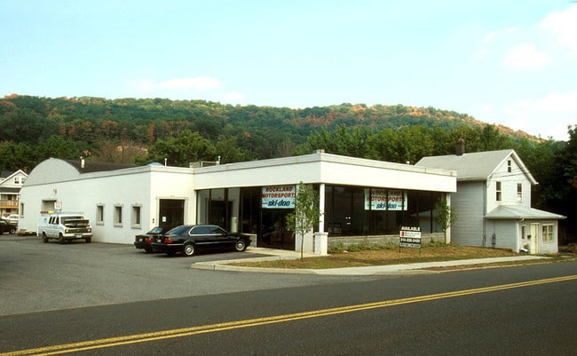
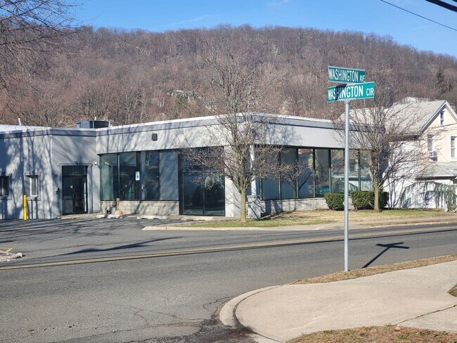
Property Record
23 Washington Ave, Tappan, NY 10983

NEARBY LISTINGS FOR SALE OR LEASE
Property Detail
23 Washington Ave
392607-054-028-0001-026-000-0000
+130,139A3,111K
Warehouse
Rockland
X
New York
34003C0057H
26.0
2023
0.65 AC
2024
Rockland County
013401
Northern New Jersey
19,328 SF
New York-Jersey City-White Plains, NY-NJ
DEMOGRAPHICS near 23 Washington Ave
1 Mile
3 Mile
5 Mile
2024 Total Population
8,708
39,788
131,508
2029 Population
8,630
39,822
131,186
Pop Growth 2024-2029
(0.90%)
+ 0.09%
(0.24%)
Average Age
40
42
35
2024 Total Households
3,273
15,012
39,257
HH Growth 2024-2029
(0.86%)
+ 0.05%
(0.16%)
Median Household Inc
$98,827
$106,484
$97,899
Avg Household Size
2.50
2.50
3.20
2024 Avg HH Vehicles
2.00
2.00
2.00
Median Home Value
$372,252
$488,826
$634,077
Median Year Built
1960
1975
1975
Nearby Places
Map Layers
Map Styles
 Street
 Aerial
- Restaurants
- Banks
- Shops
- Fitness
- Groceries
PUBLIC TRANSPORTATION
TRANSIT/SUBWAY
Suffern (Bergen County/Port Jervis Line - NJ Transit Commuter Rail (NJ Transit), Main/Port Jervis Line - NJ Transit Commuter Rail (NJ Transit))
DRIVE
WALK
Distance
Suffern (Bergen County/Port Jervis Line - NJ Transit Commuter Rail (NJ Transit), Main/Port Jervis Line - NJ Transit Commuter Rail (NJ Transit))
2 min
11 min
0.6 mi
COMMUTER RAIL
Suffern (Bergen County/Port Jervis Line - NJ Transit Commuter Rail (NJ Transit), Main/Port Jervis Line - NJ Transit Commuter Rail (NJ Transit))
DRIVE
WALK
Distance
Suffern (Bergen County/Port Jervis Line - NJ Transit Commuter Rail (NJ Transit), Main/Port Jervis Line - NJ Transit Commuter Rail (NJ Transit))
2 min
11 min
0.6 mi
Mahwah (Bergen County/Port Jervis Line - NJ Transit Commuter Rail (NJ Transit), Main/Port Jervis Line - NJ Transit Commuter Rail (NJ Transit))
DRIVE
WALK
Distance
Mahwah (Bergen County/Port Jervis Line - NJ Transit Commuter Rail (NJ Transit), Main/Port Jervis Line - NJ Transit Commuter Rail (NJ Transit))
4 min
1.8 mi
AIRPORT
Westchester County
DRIVE
WALK
Distance
Westchester County
44 min
30.7 mi
LaGuardia
DRIVE
WALK
Distance
LaGuardia
57 min
34.1 mi
New York Stewart International
DRIVE
WALK
Distance
New York Stewart International
47 min
35.4 mi
Freight Ports
Maher Terminal
DRIVE
WALK
Distance
Maher Terminal
58 min
36.6 mi
SALE & LEASE HISTORY
LISTING DATE
SALE/LEASE

Jan 26, 2021
For Lease
Aug 09, 2020
For Sale
Nearby Properties
Address
Land Use
TOTAL SIZE
Lot Size
Zoning
Address
Land Use
TOTAL SIZE
Lot Size
Zoning
284 AC
P40
Address
Land Use
TOTAL SIZE
Lot Size
Zoning
28.28 AC
GI80
Address
Land Use
TOTAL SIZE
Lot Size
Zoning
46.89 AC
IP120
Address
Land Use
TOTAL SIZE
Lot Size
Zoning
1,056 SF
99.35 AC
OP200
Address
Land Use
TOTAL SIZE
Lot Size
Zoning
61.37 AC
PED
Address
Land Use
TOTAL SIZE
Lot Size
Zoning
23.32 AC
Address
Land Use
TOTAL SIZE
Lot Size
Zoning
14.09 AC
B200
Address
Land Use
TOTAL SIZE
Lot Size
Zoning
Address
Land Use
TOTAL SIZE
Lot Size
Zoning
15.98 AC
Address
Land Use
TOTAL SIZE
Lot Size
Zoning
68.78 AC
OP20
Address
Land Use
TOTAL SIZE
Lot Size
Zoning
19.60 AC
OP200
Address
Land Use
TOTAL SIZE
Lot Size
Zoning
5.67 AC
Address
Land Use
TOTAL SIZE
Lot Size
Zoning
6.76 AC
IP120
Address
Land Use
TOTAL SIZE
Lot Size
Zoning
33.78 AC
CEDR40
Address
Land Use
TOTAL SIZE
Lot Size
Zoning
539,911 SF
38.80 AC
05
Address
Land Use
TOTAL SIZE
Lot Size
Zoning
33.50 AC
GI80
Address
Land Use
TOTAL SIZE
Lot Size
Zoning
91,596 SF
15.10 AC
B40
Address
Land Use
TOTAL SIZE
Lot Size
Zoning
18.86 AC
IP120
Address
Land Use
TOTAL SIZE
Lot Size
Zoning
219,765 SF
29.88 AC
07
Address
Land Use
TOTAL SIZE
Lot Size
Zoning
10.08 AC
IP120
Address
Land Use
TOTAL SIZE
Lot Size
Zoning
60,600 SF
5.02 AC
B3
Address
Land Use
TOTAL SIZE
Lot Size
Zoning
60,222 SF
17.39 AC
LO
Address
Land Use
TOTAL SIZE
Lot Size
Zoning
12.77 AC
GI80
Address
Land Use
TOTAL SIZE
Lot Size
Zoning
5.30 AC
GA200
Address
Land Use
TOTAL SIZE
Lot Size
Zoning
0.44 AC
OP20
Address
Land Use
TOTAL SIZE
Lot Size
Zoning
9 AC
B40
Address
Land Use
TOTAL SIZE
Lot Size
Zoning
7.26 AC
GA200
Address
Land Use
TOTAL SIZE
Lot Size
Zoning
8.43 AC
IP120
Address
Land Use
TOTAL SIZE
Lot Size
Zoning
5.31 AC
GA200
Address
Land Use
TOTAL SIZE
Lot Size
Zoning
11.09 AC
IP120
The World's #1 Commercial Real Estate Marketplace
Connect with us
© 2026 CoStar Group
The information above has been obtained from sources believed reliable. While we do not doubt its accuracy we have not verified it and make no guarantee, warranty or representation about it. It is your responsibility to independently confirm its accuracy and completeness. Any projections, opinions, assumptions, or estimates used are for example only and do not represent the current or future performance of the property. The value of this transaction to you depends on tax and other factors which should be evaluated by your tax, financial, and legal advisors. You and your advisors should conduct a careful, independent investigation of the property to determine to your satisfaction the suitability of the property for your needs.