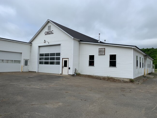
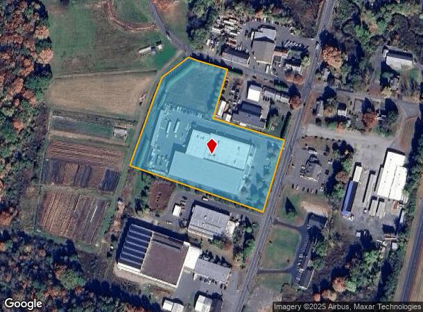
Property Record
21 West St, West Hatfield, MA 01088

NEARBY LISTINGS FOR SALE OR LEASE
Property Detail
21 West St
HATF-000224-000342A
Hampshire
Regionalshoppingcenterormallwithanchorstore
Massachusetts
2025
5.21 AC
2025
Hampshire County
821500
Hartford
55,644 SF
Springfield, MA
DEMOGRAPHICS near 21 West St
1 Mile
3 Mile
5 Mile
2024 Total Population
1,099
11,550
34,041
2029 Population
865
8,999
27,231
Pop Growth 2024-2029
(21.29%)
(22.09%)
(20.01%)
Average Age
50
46
44
2024 Total Households
519
5,305
14,743
HH Growth 2024-2029
(21.58%)
(22.68%)
(21.67%)
Median Household Inc
$82,954
$78,013
$79,130
Avg Household Size
2.00
2.10
2.10
2024 Avg HH Vehicles
2.00
2.00
2.00
Median Home Value
$375,651
$385,665
$389,550
Median Year Built
1968
1956
1956
Nearby Places
Map Layers
Map Styles
 Street
 Aerial
- Restaurants
- Banks
- Shops
- Fitness
- Groceries
PUBLIC TRANSPORTATION
COMMUTER RAIL
Northampton (Valley Flyer - Amtrak, Vermonter - Amtrak)
DRIVE
WALK
Distance
Northampton (Valley Flyer - Amtrak, Vermonter - Amtrak)
9 min
4.1 mi
AIRPORT
Bradley International
DRIVE
WALK
Distance
Bradley International
57 min
34.0 mi
Freight Ports
Albany, NY Port
DRIVE
WALK
Distance
Albany, NY Port
117 min
96.0 mi
SALE & LEASE HISTORY
LISTING DATE
SALE/LEASE

Jun 01, 2020
For Sale
Jan 01, 2022
For Sale
Nearby Properties
Address
Land Use
TOTAL SIZE
Lot Size
Zoning
Address
Land Use
TOTAL SIZE
Lot Size
Zoning
476,724 SF
57.56 AC
I
Address
Land Use
TOTAL SIZE
Lot Size
Zoning
9,424 SF
17.24 AC
AR
Address
Land Use
TOTAL SIZE
Lot Size
Zoning
18.04 AC
URB
Address
Land Use
TOTAL SIZE
Lot Size
Zoning
143,471 SF
22.12 AC
URA
Address
Land Use
TOTAL SIZE
Lot Size
Zoning
26.50 AC
URB
Address
Land Use
TOTAL SIZE
Lot Size
Zoning
12.23 AC
HB
Address
Land Use
TOTAL SIZE
Lot Size
Zoning
30.42 AC
URB
Address
Land Use
TOTAL SIZE
Lot Size
Zoning
7.58 AC
HB
Address
Land Use
TOTAL SIZE
Lot Size
Zoning
10.37 AC
HB
Address
Land Use
TOTAL SIZE
Lot Size
Zoning
21.77 AC
GI
Address
Land Use
TOTAL SIZE
Lot Size
Zoning
359,938 SF
38.84 AC
I
Address
Land Use
TOTAL SIZE
Lot Size
Zoning
131.99 AC
HB
Address
Land Use
TOTAL SIZE
Lot Size
Zoning
59,471 SF
35 AC
LGT
Address
Land Use
TOTAL SIZE
Lot Size
Zoning
4.19 AC
HB
Address
Land Use
TOTAL SIZE
Lot Size
Zoning
42,070 SF
4.38 AC
URA
Address
Land Use
TOTAL SIZE
Lot Size
Zoning
5.36 AC
HB
Address
Land Use
TOTAL SIZE
Lot Size
Zoning
5.06 AC
URC
Address
Land Use
TOTAL SIZE
Lot Size
Zoning
53,344 SF
9.07 AC
TC
Address
Land Use
TOTAL SIZE
Lot Size
Zoning
280,518 SF
60.66 AC
I
Address
Land Use
TOTAL SIZE
Lot Size
Zoning
63.16 AC
URB
Address
Land Use
TOTAL SIZE
Lot Size
Zoning
10.07 AC
URB
Address
Land Use
TOTAL SIZE
Lot Size
Zoning
16.77 AC
SI
Address
Land Use
TOTAL SIZE
Lot Size
Zoning
49,757 SF
11.07 AC
SR
Address
Land Use
TOTAL SIZE
Lot Size
Zoning
6,930 SF
2.95 AC
HB
Address
Land Use
TOTAL SIZE
Lot Size
Zoning
23,619 SF
2 AC
HB
Address
Land Use
TOTAL SIZE
Lot Size
Zoning
768 SF
2.13 AC
URB
Address
Land Use
TOTAL SIZE
Lot Size
Zoning
38,194 SF
3.42 AC
HB
Address
Land Use
TOTAL SIZE
Lot Size
Zoning
938 AC
RR
Address
Land Use
TOTAL SIZE
Lot Size
Zoning
2.88 AC
URB
The World's #1 Commercial Real Estate Marketplace
Connect with us
© 2025 CoStar Group
The information above has been obtained from sources believed reliable. While we do not doubt its accuracy we have not verified it and make no guarantee, warranty or representation about it. It is your responsibility to independently confirm its accuracy and completeness. Any projections, opinions, assumptions, or estimates used are for example only and do not represent the current or future performance of the property. The value of this transaction to you depends on tax and other factors which should be evaluated by your tax, financial, and legal advisors. You and your advisors should conduct a careful, independent investigation of the property to determine to your satisfaction the suitability of the property for your needs.