Property Record
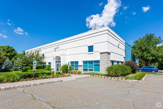
23 Wilson Dr, Sparta, NJ 07871


Property Detail
23 Wilson Dr
18-12006-0000-00019
SUSSEX
Warehouse
New Jersey
ED
19
B and X Area of moderate flood hazard, usually the area between the limits of the 100-year and 500-year floods.
2.71 AC
2024
Sussex County
2025
Northern New Jersey
373100
Newark, NJ
14,865 SF
NEARBY LISTINGS FOR SALE OR LEASE
DEMOGRAPHICS near 23 Wilson Dr
1 mile
3 mile
5 mile
2025 Total Population
703
8,269
35,380
2030 Population
740
8,472
36,107
Pop Growth 2025-2030
+ 5.26%
+ 2.45%
+ 2.05%
Average Age
41
43
43
2025 Total Households
236
2,966
13,438
HH Growth 2025-2030
+ 5.08%
+ 2.12%
+ 2.04%
Median Household Inc
$155,952
$138,058
$120,791
Avg Household Size
2.90
2.70
2.60
2025 Avg HH Vehicles
2.00
2.00
2.00
Median Home Value
$525,229
$492,652
$421,103
Median Year Built
1988
1984
1971
Nearby Places
Map Layers
Map Styles
 Street
 Aerial
Layers
 Traffic
 Biking
Places
Listings with unknown addresses are not visible on the map
- Restaurants
- Banks
- Shops
- Fitness
- Groceries
SALE & LEASE HISTORY
LISTING DATE
SALE/LEASE

Dec 06, 2016
For Lease
Nearby Properties
Address
Land Use
TOTAL SIZE
Lot Size
Zoning
Address
Land Use
TOTAL SIZE
Lot Size
Zoning
134,375 SF
27.71 AC
OSGU
Address
Land Use
TOTAL SIZE
Lot Size
Zoning
156,719 SF
48.98 AC
OSGU
Address
Land Use
TOTAL SIZE
Lot Size
Zoning
28.91 AC
PVC
Address
Land Use
TOTAL SIZE
Lot Size
Zoning
2.02 AC
PVC
Address
Land Use
TOTAL SIZE
Lot Size
Zoning
50,659 SF
9.90 AC
C-2
Address
Land Use
TOTAL SIZE
Lot Size
Zoning
45,532 SF
10.31 AC
R1
Address
Land Use
TOTAL SIZE
Lot Size
Zoning
2.27 AC
PVC
Address
Land Use
TOTAL SIZE
Lot Size
Zoning
58,605 SF
28.29 AC
OSGU
Address
Land Use
TOTAL SIZE
Lot Size
Zoning
35,884 SF
4.73 AC
C-2
Address
Land Use
TOTAL SIZE
Lot Size
Zoning
29,156 SF
121.97 AC
L-1
Address
Land Use
TOTAL SIZE
Lot Size
Zoning
58.78 AC
PDRM
Address
Land Use
TOTAL SIZE
Lot Size
Zoning
15,400 SF
53.92 AC
PDRM
Address
Land Use
TOTAL SIZE
Lot Size
Zoning
65,064 SF
7.17 AC
L-1
Address
Land Use
TOTAL SIZE
Lot Size
Zoning
31,504 SF
3.06 AC
ED-1
Address
Land Use
TOTAL SIZE
Lot Size
Zoning
23,184 SF
82.13 AC
OSGU
Address
Land Use
TOTAL SIZE
Lot Size
Zoning
29.26 AC
HCR3
Address
Land Use
TOTAL SIZE
Lot Size
Zoning
10 AC
RR
Address
Land Use
TOTAL SIZE
Lot Size
Zoning
42,036 SF
2.94 AC
C-1
Address
Land Use
TOTAL SIZE
Lot Size
Zoning
59,919 SF
21.22 AC
R-2
Address
Land Use
TOTAL SIZE
Lot Size
Zoning
45,445 SF
8.65 AC
ED
Address
Land Use
TOTAL SIZE
Lot Size
Zoning
28,317 SF
1.36 AC
C-2
Address
Land Use
TOTAL SIZE
Lot Size
Zoning
6.08 AC
PVC
Address
Land Use
TOTAL SIZE
Lot Size
Zoning
23,812 SF
2.29 AC
C-1
Address
Land Use
TOTAL SIZE
Lot Size
Zoning
4,160 SF
96.54 AC
OSGU
Address
Land Use
TOTAL SIZE
Lot Size
Zoning
20,386 SF
1.91 AC
MF
Address
Land Use
TOTAL SIZE
Lot Size
Zoning
24,461 SF
5 AC
TCPB
Address
Land Use
TOTAL SIZE
Lot Size
Zoning
23,776 SF
190.85 AC
R1
Address
Land Use
TOTAL SIZE
Lot Size
Zoning
70.27 AC
E-D
Address
Land Use
TOTAL SIZE
Lot Size
Zoning
8.56 AC
ED
Address
Land Use
TOTAL SIZE
Lot Size
Zoning
17,524 SF
160.18 AC
R-2
The World's #1 Commercial Real Estate Marketplace
Connect with us
© 2026 CoStar Group
The information above has been obtained from sources believed reliable. While we do not doubt its accuracy we have not verified it and make no guarantee, warranty or representation about it. It is your responsibility to independently confirm its accuracy and completeness. Any projections, opinions, assumptions, or estimates used are for example only and do not represent the current or future performance of the property. The value of this transaction to you depends on tax and other factors which should be evaluated by your tax, financial, and legal advisors. You and your advisors should conduct a careful, independent investigation of the property to determine to your satisfaction the suitability of the property for your needs.