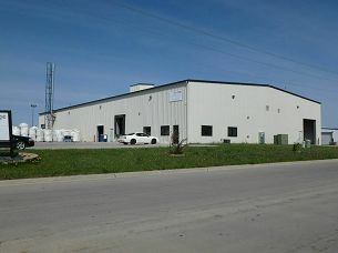
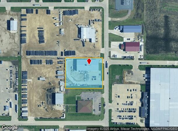
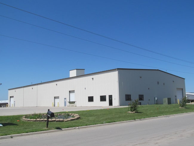
Property Record
230 15Th St Nw, West Fargo, ND 58078

NEARBY LISTINGS FOR SALE OR LEASE
-
-
No Photo
-
-
View all West Fargo listings for sale on LoopNet.com
Property Detail
230 15Th St Nw
02-0032-00080-000
Butlers Third Addition
Realpropertynec
LOT: 6 BLOCK: 2 ADDITION: BUTLER 3RD ADDITION ADDITIONAL: BUTLER'S 3RD LT 6 BLK 2
X
Cass
38017C0568G
North Dakota
2024
6
2024
2.20 AC
010201
Other Market Areas
20,000 SF
Fargo, ND-MN
DEMOGRAPHICS near 230 15Th St Nw
1 Mile
3 Mile
5 Mile
2024 Total Population
1,075
23,421
71,382
2029 Population
1,137
25,111
76,697
Pop Growth 2024-2029
+ 5.77%
+ 7.22%
+ 7.45%
Average Age
39
38
35
2024 Total Households
457
9,631
31,082
HH Growth 2024-2029
+ 6.35%
+ 7.66%
+ 7.85%
Median Household Inc
$70,351
$79,786
$68,834
Avg Household Size
2.30
2.40
2.20
2024 Avg HH Vehicles
2.00
2.00
2.00
Median Home Value
$233,333
$244,581
$265,951
Median Year Built
1983
1994
2003
Nearby Places
Map Layers
Map Styles
 Street
 Aerial
- Restaurants
- Banks
- Shops
- Fitness
- Groceries
PUBLIC TRANSPORTATION
COMMUTER RAIL
Fargo Amtrak Station (Empire Builder - Amtrak)
DRIVE
WALK
Distance
Fargo Amtrak Station (Empire Builder - Amtrak)
15 min
7.6 mi
AIRPORT
Hector International
DRIVE
WALK
Distance
Hector International
18 min
10.0 mi
Freight Ports
Port Milwaukee
DRIVE
WALK
Distance
Port Milwaukee
638 min
579.4 mi
SALE & LEASE HISTORY
LISTING DATE
SALE/LEASE

Jan 23, 2019
For Sale
Nearby Properties
Address
Land Use
TOTAL SIZE
Lot Size
Zoning
Address
Land Use
TOTAL SIZE
Lot Size
Zoning
206,540 SF
16.68 AC
GI
Address
Land Use
TOTAL SIZE
Lot Size
Zoning
49.50 AC
Address
Land Use
TOTAL SIZE
Lot Size
Zoning
15,895 SF
41.76 AC
Address
Land Use
TOTAL SIZE
Lot Size
Zoning
184,560 SF
17.11 AC
Address
Land Use
TOTAL SIZE
Lot Size
Zoning
99,300 SF
12.72 AC
Address
Land Use
TOTAL SIZE
Lot Size
Zoning
207,189 SF
23.72 AC
Address
Land Use
TOTAL SIZE
Lot Size
Zoning
79,310 SF
17.79 AC
Address
Land Use
TOTAL SIZE
Lot Size
Zoning
354,677 SF
13.13 AC
Address
Land Use
TOTAL SIZE
Lot Size
Zoning
8,166 SF
8.26 AC
Address
Land Use
TOTAL SIZE
Lot Size
Zoning
101,324 SF
7.12 AC
LI
Address
Land Use
TOTAL SIZE
Lot Size
Zoning
156,450 SF
14.92 AC
Address
Land Use
TOTAL SIZE
Lot Size
Zoning
240,766 SF
15.14 AC
Address
Land Use
TOTAL SIZE
Lot Size
Zoning
131,360 SF
4.52 AC
Address
Land Use
TOTAL SIZE
Lot Size
Zoning
141,474 SF
16.03 AC
GC
Address
Land Use
TOTAL SIZE
Lot Size
Zoning
Address
Land Use
TOTAL SIZE
Lot Size
Zoning
180,000 SF
10.73 AC
Address
Land Use
TOTAL SIZE
Lot Size
Zoning
207,189 SF
22.99 AC
Address
Land Use
TOTAL SIZE
Lot Size
Zoning
13,970 SF
32.10 AC
Address
Land Use
TOTAL SIZE
Lot Size
Zoning
Address
Land Use
TOTAL SIZE
Lot Size
Zoning
79,192 SF
1.66 AC
Address
Land Use
TOTAL SIZE
Lot Size
Zoning
76,743 SF
5.69 AC
Address
Land Use
TOTAL SIZE
Lot Size
Zoning
16.39 AC
Address
Land Use
TOTAL SIZE
Lot Size
Zoning
193,114 SF
9.96 AC
Address
Land Use
TOTAL SIZE
Lot Size
Zoning
89,352 SF
2.59 AC
Address
Land Use
TOTAL SIZE
Lot Size
Zoning
90,551 SF
8.29 AC
Address
Land Use
TOTAL SIZE
Lot Size
Zoning
70,800 SF
9.18 AC
Address
Land Use
TOTAL SIZE
Lot Size
Zoning
46,114 SF
6 AC
Address
Land Use
TOTAL SIZE
Lot Size
Zoning
60,947 SF
4.48 AC
Address
Land Use
TOTAL SIZE
Lot Size
Zoning
74,256 SF
2.35 AC
Address
Land Use
TOTAL SIZE
Lot Size
Zoning
The World's #1 Commercial Real Estate Marketplace
Connect with us
© 2025 CoStar Group
The information above has been obtained from sources believed reliable. While we do not doubt its accuracy we have not verified it and make no guarantee, warranty or representation about it. It is your responsibility to independently confirm its accuracy and completeness. Any projections, opinions, assumptions, or estimates used are for example only and do not represent the current or future performance of the property. The value of this transaction to you depends on tax and other factors which should be evaluated by your tax, financial, and legal advisors. You and your advisors should conduct a careful, independent investigation of the property to determine to your satisfaction the suitability of the property for your needs.