Property Record
230 Alta Dale Ave Se, Ada, MI 49301
NEARBY LISTINGS FOR SALE OR LEASE
-
-
View all Ada listings for sale on LoopNet.com
Property Detail
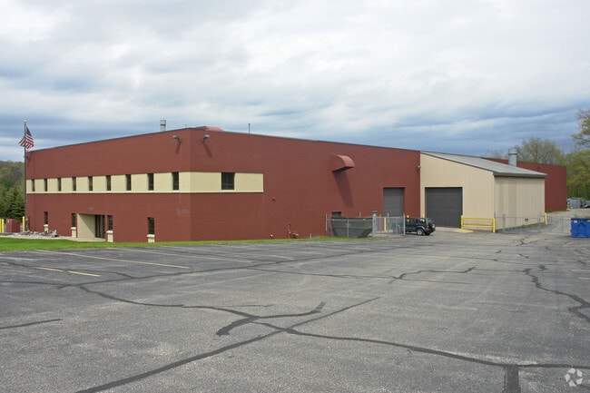
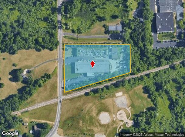
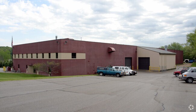
230 Alta Dale Ave Se
41-15-29-327-006
Grand Rapids
Industrialgeneral
PART OF E 1/4 SW 1/4 COM 268.27 FT N ALONG N&S 1/4 LINE FROM N LINE OF GRAND RAPIDS EASTERN /FORMERLY CENTRAL MICH-FORMERLY
X
Kent
26081C0434D
Michigan
2024
5.52 AC
2025
Ada/Lowell
011902
West Michigan
39,904 SF
Grand Rapids-Wyoming, MI
DEMOGRAPHICS near 230 Alta Dale Ave Se
1 Mile
3 Mile
5 Mile
2024 Total Population
4,198
24,743
77,024
2029 Population
4,233
25,056
77,737
Pop Growth 2024-2029
+ 0.83%
+ 1.27%
+ 0.93%
Average Age
40
41
40
2024 Total Households
1,472
8,613
28,277
HH Growth 2024-2029
+ 0.82%
+ 1.30%
+ 0.92%
Median Household Inc
$118,247
$124,904
$104,508
Avg Household Size
2.90
2.80
2.60
2024 Avg HH Vehicles
2.00
2.00
2.00
Median Home Value
$358,333
$391,862
$383,992
Median Year Built
1992
1991
1981
Nearby Places
Map Layers
Map Styles
 Street
 Aerial
- Restaurants
- Banks
- Shops
- Fitness
- Groceries
PUBLIC TRANSPORTATION
AIRPORT
Gerald R Ford International
DRIVE
WALK
Distance
Gerald R Ford International
22 min
11.0 mi
Nearby Properties
Address
Land Use
TOTAL SIZE
Lot Size
Zoning
Address
Land Use
TOTAL SIZE
Lot Size
Zoning
277.36 AC
I
Address
Land Use
TOTAL SIZE
Lot Size
Zoning
709,488 SF
106.95 AC
LI
Address
Land Use
TOTAL SIZE
Lot Size
Zoning
126,805 SF
9.36 AC
C4
Address
Land Use
TOTAL SIZE
Lot Size
Zoning
151,708 SF
7.22 AC
C4
Address
Land Use
TOTAL SIZE
Lot Size
Zoning
Address
Land Use
TOTAL SIZE
Lot Size
Zoning
226,877 SF
22.40 AC
R2
Address
Land Use
TOTAL SIZE
Lot Size
Zoning
138,278 SF
35.63 AC
R-1
Address
Land Use
TOTAL SIZE
Lot Size
Zoning
154,643 SF
10.96 AC
O-PUD
Address
Land Use
TOTAL SIZE
Lot Size
Zoning
183,583 SF
9.12 AC
R-1
Address
Land Use
TOTAL SIZE
Lot Size
Zoning
8.97 AC
Address
Land Use
TOTAL SIZE
Lot Size
Zoning
105,029 SF
5.65 AC
C
Address
Land Use
TOTAL SIZE
Lot Size
Zoning
Address
Land Use
TOTAL SIZE
Lot Size
Zoning
110,706 SF
23.76 AC
C4
Address
Land Use
TOTAL SIZE
Lot Size
Zoning
Address
Land Use
TOTAL SIZE
Lot Size
Zoning
1,144 SF
4.15 AC
PUD
Address
Land Use
TOTAL SIZE
Lot Size
Zoning
86,082 SF
171.94 AC
R-1
Address
Land Use
TOTAL SIZE
Lot Size
Zoning
33,540 SF
5.67 AC
PO
Address
Land Use
TOTAL SIZE
Lot Size
Zoning
79,374 SF
12.20 AC
C-2
Address
Land Use
TOTAL SIZE
Lot Size
Zoning
14,700 SF
1.44 AC
Address
Land Use
TOTAL SIZE
Lot Size
Zoning
81,494 SF
21.36 AC
R-1
Address
Land Use
TOTAL SIZE
Lot Size
Zoning
59,200 SF
7.62 AC
C-1
Address
Land Use
TOTAL SIZE
Lot Size
Zoning
0.65 AC
Address
Land Use
TOTAL SIZE
Lot Size
Zoning
50,984 SF
2.60 AC
C-1
Address
Land Use
TOTAL SIZE
Lot Size
Zoning
67,789 SF
9.51 AC
O-PUD
Address
Land Use
TOTAL SIZE
Lot Size
Zoning
66,036 SF
4.38 AC
O-PUD
Address
Land Use
TOTAL SIZE
Lot Size
Zoning
63,820 SF
3.25 AC
PUD
Address
Land Use
TOTAL SIZE
Lot Size
Zoning
37,631 SF
6.49 AC
O-PUD
Address
Land Use
TOTAL SIZE
Lot Size
Zoning
Address
Land Use
TOTAL SIZE
Lot Size
Zoning
64,790 SF
290,921.90 AC
PUD
Address
Land Use
TOTAL SIZE
Lot Size
Zoning
28,564 SF
4.01 AC
C4
The World's #1 Commercial Real Estate Marketplace
Connect with us
© 2026 CoStar Group
The information above has been obtained from sources believed reliable. While we do not doubt its accuracy we have not verified it and make no guarantee, warranty or representation about it. It is your responsibility to independently confirm its accuracy and completeness. Any projections, opinions, assumptions, or estimates used are for example only and do not represent the current or future performance of the property. The value of this transaction to you depends on tax and other factors which should be evaluated by your tax, financial, and legal advisors. You and your advisors should conduct a careful, independent investigation of the property to determine to your satisfaction the suitability of the property for your needs.