Property Record
230 Bomarc Rd, Bangor, ME 04401

NEARBY LISTINGS FOR SALE OR LEASE
Property Detail
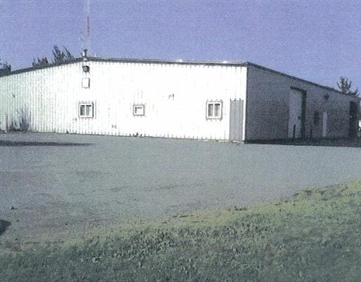
230 Bomarc Rd
BANG-000038R-000000-000001
Penobscot
Residentialnec
Maine
X
1
23019C2106D
10.40 AC
2024
Maine North & Bangor
2024
Other Market Areas
031100
Bangor, ME
DEMOGRAPHICS near 230 Bomarc Rd
1 mile
3 mile
5 mile
2024 Total Population
1,596
20,760
46,348
2029 Population
1,636
21,389
47,581
Pop Growth 2024-2029
+ 2.51%
+ 3.03%
+ 2.66%
Average Age
47
42
42
2024 Total Households
733
8,996
20,985
HH Growth 2024-2029
+ 2.59%
+ 3.19%
+ 2.79%
Median Household Inc
$86,309
$56,720
$54,058
Avg Household Size
2.20
2.10
2.10
2024 Avg HH Vehicles
2.00
2.00
2.00
Median Home Value
$275,780
$189,512
$200,686
Median Year Built
1996
1976
1966
Nearby Places
Map Layers
Map Styles
 Street
 Aerial
Transit
 Traffic
 Biking
Places
Listings with unknown addresses are not visible on the map
- Restaurants
- Banks
- Shops
- Fitness
- Groceries
PUBLIC TRANSPORTATION
AIRPORT
Bangor International
Drive
Walk
Distance
Bangor International
21 min
8.2 mi
Nearby Properties
Address
Land Use
TOTAL SIZE
Lot Size
Zoning
Address
Land Use
TOTAL SIZE
Lot Size
Zoning
76,649 SF
100 AC
G&ISD
Address
Land Use
TOTAL SIZE
Lot Size
Zoning
124,368 SF
11.75 AC
G&ISD
Address
Land Use
TOTAL SIZE
Lot Size
Zoning
241,898 SF
62.50 AC
G&ISD
Address
Land Use
TOTAL SIZE
Lot Size
Zoning
146,924 SF
2.62 AC
G&ISD
Address
Land Use
TOTAL SIZE
Lot Size
Zoning
Address
Land Use
TOTAL SIZE
Lot Size
Zoning
226,625 SF
S&PS
Address
Land Use
TOTAL SIZE
Lot Size
Zoning
208,790 SF
50.33 AC
S&PS
Address
Land Use
TOTAL SIZE
Lot Size
Zoning
186,197 SF
21.70 AC
S&PS
Address
Land Use
TOTAL SIZE
Lot Size
Zoning
25,567 SF
68 AC
HDR
Address
Land Use
TOTAL SIZE
Lot Size
Zoning
183,507 SF
44.60 AC
G&ISD
Address
Land Use
TOTAL SIZE
Lot Size
Zoning
119,930 SF
9.50 AC
S&PS
Address
Land Use
TOTAL SIZE
Lot Size
Zoning
28 AC
HDR
Address
Land Use
TOTAL SIZE
Lot Size
Zoning
111,000 SF
18.87 AC
HDR
Address
Land Use
TOTAL SIZE
Lot Size
Zoning
102,163 SF
9.83 AC
HDR
Address
Land Use
TOTAL SIZE
Lot Size
Zoning
604,872 SF
67.61 AC
S&PS
Address
Land Use
TOTAL SIZE
Lot Size
Zoning
140,059 SF
15.38 AC
S&PS
Address
Land Use
TOTAL SIZE
Lot Size
Zoning
138,902 SF
20 AC
HDR
Address
Land Use
TOTAL SIZE
Lot Size
Zoning
246,766 SF
22.44 AC
S&PS
Address
Land Use
TOTAL SIZE
Lot Size
Zoning
104,534 SF
5 AC
GC&S
Address
Land Use
TOTAL SIZE
Lot Size
Zoning
130,786 SF
17.33 AC
GC&S
Address
Land Use
TOTAL SIZE
Lot Size
Zoning
123,814 SF
11.23 AC
GC&S
Address
Land Use
TOTAL SIZE
Lot Size
Zoning
72,720 SF
14.11 AC
HDR
Address
Land Use
TOTAL SIZE
Lot Size
Zoning
61,464 SF
20.03 AC
GC&S
Address
Land Use
TOTAL SIZE
Lot Size
Zoning
87,386 SF
13.50 AC
G&ISD
Address
Land Use
TOTAL SIZE
Lot Size
Zoning
72,377 SF
11.97 AC
GC&S
Address
Land Use
TOTAL SIZE
Lot Size
Zoning
122,390 SF
13 AC
S&PS
Address
Land Use
TOTAL SIZE
Lot Size
Zoning
33,608 SF
18.10 AC
G&ISD
Address
Land Use
TOTAL SIZE
Lot Size
Zoning
94,280 SF
2.25 AC
G&ISD
Address
Land Use
TOTAL SIZE
Lot Size
Zoning
74,456 SF
S&PS
Address
Land Use
TOTAL SIZE
Lot Size
Zoning
The World's #1 Commercial Real Estate Marketplace
Connect with us
© 2026 CoStar Group
The information above has been obtained from sources believed reliable. While we do not doubt its accuracy we have not verified it and make no guarantee, warranty or representation about it. It is your responsibility to independently confirm its accuracy and completeness. Any projections, opinions, assumptions, or estimates used are for example only and do not represent the current or future performance of the property. The value of this transaction to you depends on tax and other factors which should be evaluated by your tax, financial, and legal advisors. You and your advisors should conduct a careful, independent investigation of the property to determine to your satisfaction the suitability of the property for your needs.