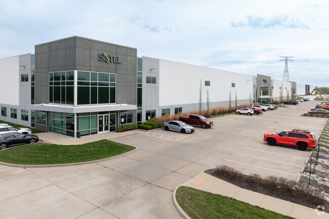
Property Record
230 Carondelet Commons Blvd, Saint Louis, MO 63111

Current Lease Availabilities
NEARBY LISTINGS FOR SALE OR LEASE
Property Detail
230 Carondelet Commons Blvd
St. Louis, MO-IL
Patch
32590000451
CB 3259 CARONDELET COMMONS BLVD & PT CB 3250 & CB 3260 & 3262 12.039 ACRES BNDRY ADJ CRONDELET COMMONS PLAT 2 & CARONDELET COMMONS PLAT 2
Commercialnec
St. Louis City
AE
Missouri
17133C0020F
1
2024
11.91 AC
2025
St Louis City South
101500
St. Louis
124,890 SF
DEMOGRAPHICS near 230 Carondelet Commons Blvd
1 Mile
3 Mile
5 Mile
2024 Total Population
7,699
74,700
213,632
2029 Population
7,499
71,183
203,099
Pop Growth 2024-2029
(2.60%)
(4.71%)
(4.93%)
Average Age
39
41
41
2024 Total Households
3,157
32,757
97,269
HH Growth 2024-2029
(2.63%)
(4.80%)
(5.09%)
Median Household Inc
$45,439
$54,928
$58,221
Avg Household Size
2.30
2.20
2.10
2024 Avg HH Vehicles
2.00
2.00
2.00
Median Home Value
$98,656
$153,309
$176,039
Median Year Built
1946
1950
1951
Nearby Places
Map Layers
Map Styles
 Street
 Aerial
- Restaurants
- Banks
- Shops
- Fitness
- Groceries
PUBLIC TRANSPORTATION
COMMUTER RAIL
Shrewsbury-Lansdowne (Shrewsbury-Lansdowne I-44 Emerson Park - St. Louis MetroLink (MetroLink))
DRIVE
WALK
Distance
Shrewsbury-Lansdowne (Shrewsbury-Lansdowne I-44 Emerson Park - St. Louis MetroLink (MetroLink))
12 min
5.6 mi
Sunnen (Shrewsbury-Lansdowne I-44 Emerson Park - St. Louis MetroLink (MetroLink))
DRIVE
WALK
Distance
Sunnen (Shrewsbury-Lansdowne I-44 Emerson Park - St. Louis MetroLink (MetroLink))
16 min
7.2 mi
AIRPORT
St Louis Lambert International
DRIVE
WALK
Distance
St Louis Lambert International
33 min
19.3 mi
Scott AFB/Midamerica St Louis
DRIVE
WALK
Distance
Scott AFB/Midamerica St Louis
50 min
33.3 mi
Freight Ports
Port Milwaukee
DRIVE
WALK
Distance
Port Milwaukee
429 min
377.5 mi
Nearby Properties
Address
Land Use
TOTAL SIZE
Lot Size
Zoning
Address
Land Use
TOTAL SIZE
Lot Size
Zoning
0.92 AC
A
Address
Land Use
TOTAL SIZE
Lot Size
Zoning
5.61 AC
A
Address
Land Use
TOTAL SIZE
Lot Size
Zoning
327,966 SF
56.80 AC
FPC8
Address
Land Use
TOTAL SIZE
Lot Size
Zoning
275,354 SF
72.71 AC
FPM2
Address
Land Use
TOTAL SIZE
Lot Size
Zoning
177.77 AC
A
Address
Land Use
TOTAL SIZE
Lot Size
Zoning
3,835 SF
29.77 AC
R5
Address
Land Use
TOTAL SIZE
Lot Size
Zoning
391,268 SF
132.29 AC
R4
Address
Land Use
TOTAL SIZE
Lot Size
Zoning
90,185 SF
407.16 AC
P5
Address
Land Use
TOTAL SIZE
Lot Size
Zoning
22.44 AC
A
Address
Land Use
TOTAL SIZE
Lot Size
Zoning
150,982 SF
18.74 AC
C-8
Address
Land Use
TOTAL SIZE
Lot Size
Zoning
137,432 SF
9.18 AC
C3
Address
Land Use
TOTAL SIZE
Lot Size
Zoning
17.93 AC
R5
Address
Land Use
TOTAL SIZE
Lot Size
Zoning
267,886 SF
27.34 AC
R6
Address
Land Use
TOTAL SIZE
Lot Size
Zoning
219,361 SF
9.36 AC
M1
Address
Land Use
TOTAL SIZE
Lot Size
Zoning
9.33 AC
R5
Address
Land Use
TOTAL SIZE
Lot Size
Zoning
5.98 AC
R4
Address
Land Use
TOTAL SIZE
Lot Size
Zoning
928 SF
7.25 AC
R5
Address
Land Use
TOTAL SIZE
Lot Size
Zoning
39.88 AC
A
Address
Land Use
TOTAL SIZE
Lot Size
Zoning
89,205 SF
4.72 AC
C-8
Address
Land Use
TOTAL SIZE
Lot Size
Zoning
88,456 SF
10.48 AC
H
Address
Land Use
TOTAL SIZE
Lot Size
Zoning
99,796 SF
36 AC
NU
Address
Land Use
TOTAL SIZE
Lot Size
Zoning
5.58 AC
R4
Address
Land Use
TOTAL SIZE
Lot Size
Zoning
12.14 AC
R5
Address
Land Use
TOTAL SIZE
Lot Size
Zoning
13.81 AC
A
Address
Land Use
TOTAL SIZE
Lot Size
Zoning
102,714 SF
5.74 AC
R6
Address
Land Use
TOTAL SIZE
Lot Size
Zoning
20,296 SF
253.46 AC
NU
Address
Land Use
TOTAL SIZE
Lot Size
Zoning
12.25 AC
R5
Address
Land Use
TOTAL SIZE
Lot Size
Zoning
145,540 SF
13.66 AC
H
Address
Land Use
TOTAL SIZE
Lot Size
Zoning
10.49 AC
NU
The World's #1 Commercial Real Estate Marketplace
Connect with us
© 2025 CoStar Group
The information above has been obtained from sources believed reliable. While we do not doubt its accuracy we have not verified it and make no guarantee, warranty or representation about it. It is your responsibility to independently confirm its accuracy and completeness. Any projections, opinions, assumptions, or estimates used are for example only and do not represent the current or future performance of the property. The value of this transaction to you depends on tax and other factors which should be evaluated by your tax, financial, and legal advisors. You and your advisors should conduct a careful, independent investigation of the property to determine to your satisfaction the suitability of the property for your needs.