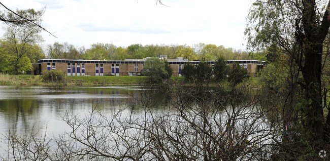
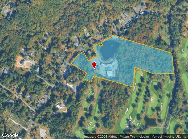
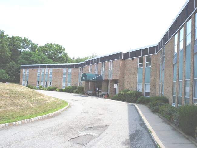
Property Record
230 Diamond Spring Rd, Denville, NJ 07834
NEARBY LISTINGS FOR SALE OR LEASE
Property Detail
230 Diamond Spring Rd
Newark, NJ-PA
FACILITY NAME: SCHOOLS
08-50601-0000-00011-01
Morris
Taxexempt
New Jersey
0
11.1
2025
29.91 AC
041300
Western Morris
65,705 SF
Northern New Jersey
DEMOGRAPHICS near 230 Diamond Spring Rd
1 Mile
3 Mile
5 Mile
2024 Total Population
5,308
45,004
137,782
2029 Population
5,495
45,178
138,225
Pop Growth 2024-2029
+ 3.52%
+ 0.39%
+ 0.32%
Average Age
47
43
42
2024 Total Households
2,042
16,582
51,314
HH Growth 2024-2029
+ 4.21%
+ 0.43%
+ 0.37%
Median Household Inc
$120,587
$134,551
$113,556
Avg Household Size
2.40
2.70
2.60
2024 Avg HH Vehicles
2.00
2.00
2.00
Median Home Value
$493,792
$482,962
$469,391
Median Year Built
1963
1962
1967
Nearby Places
Map Layers
Map Styles
 Street
 Aerial
- Restaurants
- Banks
- Shops
- Fitness
- Groceries
PUBLIC TRANSPORTATION
COMMUTER RAIL
Denville (Montclair-Boonton Line - NJ Transit Commuter Rail (NJ Transit), Morris & Essex Morristown Line - NJ Transit Commuter Rail (NJ Transit))
DRIVE
WALK
Distance
Denville (Montclair-Boonton Line - NJ Transit Commuter Rail (NJ Transit), Morris & Essex Morristown Line - NJ Transit Commuter Rail (NJ Transit))
4 min
1.8 mi
Mount Tabor (Morris & Essex Morristown Line - NJ Transit Commuter Rail (NJ Transit))
DRIVE
WALK
Distance
Mount Tabor (Morris & Essex Morristown Line - NJ Transit Commuter Rail (NJ Transit))
5 min
2.4 mi
AIRPORT
Newark Liberty International
DRIVE
WALK
Distance
Newark Liberty International
39 min
28.9 mi
Freight Ports
Maher Terminal
DRIVE
WALK
Distance
Maher Terminal
41 min
29.4 mi
Nearby Properties
Address
Land Use
TOTAL SIZE
Lot Size
Zoning
Address
Land Use
TOTAL SIZE
Lot Size
Zoning
24.83 AC
RM15
Address
Land Use
TOTAL SIZE
Lot Size
Zoning
428,141 SF
12.30 AC
OB-3
Address
Land Use
TOTAL SIZE
Lot Size
Zoning
114,267 SF
27.26 AC
SED5
Address
Land Use
TOTAL SIZE
Lot Size
Zoning
257,220 SF
30.83 AC
SED5
Address
Land Use
TOTAL SIZE
Lot Size
Zoning
Address
Land Use
TOTAL SIZE
Lot Size
Zoning
278,943 SF
45.85 AC
PED
Address
Land Use
TOTAL SIZE
Lot Size
Zoning
16.01 AC
R-C
Address
Land Use
TOTAL SIZE
Lot Size
Zoning
11.90 AC
OB3
Address
Land Use
TOTAL SIZE
Lot Size
Zoning
1,440 SF
38.80 AC
I-2
Address
Land Use
TOTAL SIZE
Lot Size
Zoning
270,140 SF
51.78 AC
R-1B
Address
Land Use
TOTAL SIZE
Lot Size
Zoning
19,436 SF
33.20 AC
PED
Address
Land Use
TOTAL SIZE
Lot Size
Zoning
217,502 SF
25 AC
SED5
Address
Land Use
TOTAL SIZE
Lot Size
Zoning
Address
Land Use
TOTAL SIZE
Lot Size
Zoning
26.65 AC
AHD7
Address
Land Use
TOTAL SIZE
Lot Size
Zoning
156,380 SF
9.72 AC
I
Address
Land Use
TOTAL SIZE
Lot Size
Zoning
5.87 AC
OL-2
Address
Land Use
TOTAL SIZE
Lot Size
Zoning
20 AC
OBRL
Address
Land Use
TOTAL SIZE
Lot Size
Zoning
379,285 SF
24.01 AC
SD5A
Address
Land Use
TOTAL SIZE
Lot Size
Zoning
171,032 SF
12.93 AC
POD
Address
Land Use
TOTAL SIZE
Lot Size
Zoning
378.93 AC
POS
Address
Land Use
TOTAL SIZE
Lot Size
Zoning
Address
Land Use
TOTAL SIZE
Lot Size
Zoning
48,455 SF
8.66 AC
POS
Address
Land Use
TOTAL SIZE
Lot Size
Zoning
124,041 SF
13.72 AC
I
Address
Land Use
TOTAL SIZE
Lot Size
Zoning
30,638 SF
7.44 AC
B-3
Address
Land Use
TOTAL SIZE
Lot Size
Zoning
13,971 SF
16.12 AC
B-1
Address
Land Use
TOTAL SIZE
Lot Size
Zoning
Address
Land Use
TOTAL SIZE
Lot Size
Zoning
271,080 SF
20.63 AC
SD5A
Address
Land Use
TOTAL SIZE
Lot Size
Zoning
72,374 SF
7.04 AC
ELRP
Address
Land Use
TOTAL SIZE
Lot Size
Zoning
211,848 SF
18.57 AC
POD
Address
Land Use
TOTAL SIZE
Lot Size
Zoning
41.21 AC
R-A
The World's #1 Commercial Real Estate Marketplace
Connect with us
© 2026 CoStar Group
The information above has been obtained from sources believed reliable. While we do not doubt its accuracy we have not verified it and make no guarantee, warranty or representation about it. It is your responsibility to independently confirm its accuracy and completeness. Any projections, opinions, assumptions, or estimates used are for example only and do not represent the current or future performance of the property. The value of this transaction to you depends on tax and other factors which should be evaluated by your tax, financial, and legal advisors. You and your advisors should conduct a careful, independent investigation of the property to determine to your satisfaction the suitability of the property for your needs.