Property Record
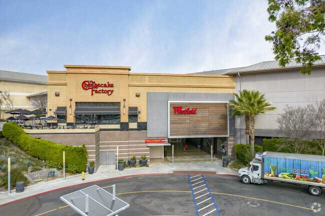
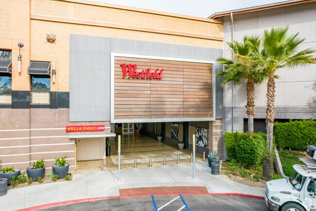
230 E Via Rancho Pkwy, Escondido, CA 92025
NEARBY LISTINGS FOR SALE OR LEASE
Property Detail
230 E Via Rancho Pkwy
760-170-24
LEASE IN PAR 2 PER PM 14270 BEING POR OF MP 1415 TR PUBLIC LAND
Regionalshoppingcenterormallwithanchorstore
San Diego
X
California
06073C1079H
7.60 AC
2025
Escondido
2025
San Diego
020708
San Diego-Carlsbad, CA
99,999 SF
DEMOGRAPHICS near 230 E Via Rancho Pkwy
1 Mile
3 Mile
5 Mile
2024 Total Population
3,645
48,187
176,140
2029 Population
3,596
47,514
174,140
Pop Growth 2024-2029
(1.34%)
(1.40%)
(1.14%)
Average Age
48
43
40
2024 Total Households
1,347
17,210
59,248
HH Growth 2024-2029
(1.56%)
(1.52%)
(1.28%)
Median Household Inc
$142,658
$111,359
$92,256
Avg Household Size
2.60
2.70
2.90
2024 Avg HH Vehicles
2.00
2.00
2.00
Median Home Value
$878,284
$809,969
$768,854
Median Year Built
1985
1980
1980
Nearby Places
Map Layers
Map Styles
 Street
 Aerial
- Restaurants
- Banks
- Shops
- Fitness
- Groceries
PUBLIC TRANSPORTATION
AIRPORT
San Diego International
DRIVE
WALK
Distance
San Diego International
36 min
27.1 mi
Freight Ports
Port of San Diego
DRIVE
WALK
Distance
Port of San Diego
39 min
29.3 mi
SALE & LEASE HISTORY
LISTING DATE
SALE/LEASE

Oct 08, 2025
For Lease
Nearby Properties
Address
Land Use
TOTAL SIZE
Lot Size
Zoning
Address
Land Use
TOTAL SIZE
Lot Size
Zoning
11.47 AC
RM-2-5
Address
Land Use
TOTAL SIZE
Lot Size
Zoning
8.42 AC
RM-2-5
Address
Land Use
TOTAL SIZE
Lot Size
Zoning
20.11 AC
RS-1-14
Address
Land Use
TOTAL SIZE
Lot Size
Zoning
7.90 AC
PD-C
Address
Land Use
TOTAL SIZE
Lot Size
Zoning
32.17 AC
PD-C
Address
Land Use
TOTAL SIZE
Lot Size
Zoning
5.82 AC
RE-20
Address
Land Use
TOTAL SIZE
Lot Size
Zoning
Address
Land Use
TOTAL SIZE
Lot Size
Zoning
13.79 AC
PD-R-11.5
Address
Land Use
TOTAL SIZE
Lot Size
Zoning
17.56 AC
RE-20
Address
Land Use
TOTAL SIZE
Lot Size
Zoning
48,800 SF
3.20 AC
PD-C
Address
Land Use
TOTAL SIZE
Lot Size
Zoning
7,520 SF
6.09 AC
RM-1-1
Address
Land Use
TOTAL SIZE
Lot Size
Zoning
3.02 AC
PD-C
Address
Land Use
TOTAL SIZE
Lot Size
Zoning
74,138 SF
4.31 AC
RE-20
Address
Land Use
TOTAL SIZE
Lot Size
Zoning
6.08 AC
S-P
Address
Land Use
TOTAL SIZE
Lot Size
Zoning
6.27 AC
R-2-8
Address
Land Use
TOTAL SIZE
Lot Size
Zoning
9.96 AC
PD-C
Address
Land Use
TOTAL SIZE
Lot Size
Zoning
78,067 SF
1.74 AC
PD-C
Address
Land Use
TOTAL SIZE
Lot Size
Zoning
7.51 AC
PD-C
Address
Land Use
TOTAL SIZE
Lot Size
Zoning
49,132 SF
2.96 AC
R-2-12
Address
Land Use
TOTAL SIZE
Lot Size
Zoning
8.20 AC
PD-C
Address
Land Use
TOTAL SIZE
Lot Size
Zoning
39,156 SF
4.68 AC
R-1-10
Address
Land Use
TOTAL SIZE
Lot Size
Zoning
56,432 SF
5.40 AC
S-P
Address
Land Use
TOTAL SIZE
Lot Size
Zoning
62,960 SF
4.18 AC
R-2-12
Address
Land Use
TOTAL SIZE
Lot Size
Zoning
77,575 SF
1.68 AC
S-P
Address
Land Use
TOTAL SIZE
Lot Size
Zoning
70,540 SF
2.46 AC
S-P
Address
Land Use
TOTAL SIZE
Lot Size
Zoning
72,488 SF
3.73 AC
S-P
Address
Land Use
TOTAL SIZE
Lot Size
Zoning
44,381 SF
4.82 AC
S-P
Address
Land Use
TOTAL SIZE
Lot Size
Zoning
9,240 SF
2.66 AC
S-P
Address
Land Use
TOTAL SIZE
Lot Size
Zoning
18.79 AC
R-T/RE-20
The World's #1 Commercial Real Estate Marketplace
Connect with us
© 2025 CoStar Group
The information above has been obtained from sources believed reliable. While we do not doubt its accuracy we have not verified it and make no guarantee, warranty or representation about it. It is your responsibility to independently confirm its accuracy and completeness. Any projections, opinions, assumptions, or estimates used are for example only and do not represent the current or future performance of the property. The value of this transaction to you depends on tax and other factors which should be evaluated by your tax, financial, and legal advisors. You and your advisors should conduct a careful, independent investigation of the property to determine to your satisfaction the suitability of the property for your needs.