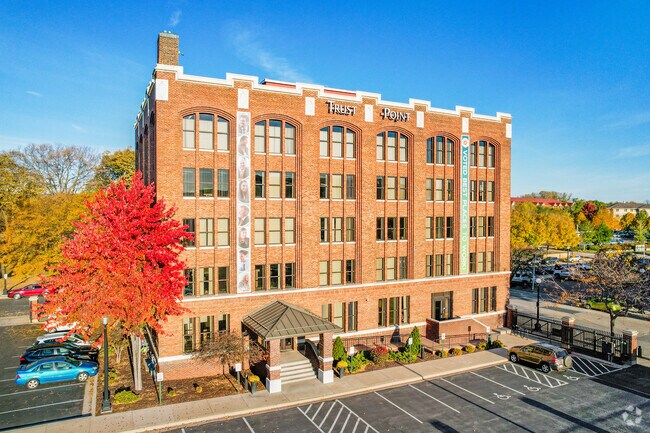
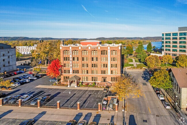
Property Record
230 Front St N, La Crosse, WI 54601
Property Detail
230 Front St N
017-020008-010
CERTIFIED SURVEY MAP NO. 123 VOL 8 LOT 8 DOC NO. 1218451 & CERTIFIED SURVEY MAP NO. 124 VOL 8 DOC NO. 1218452 LOT 7 & OUTLOT 1 SUBJ TO 66FT ACCESS ESMT IN V1297 P485 & SUBJ TO & T/W DR AGREE IN DOC NO. 1461280 & SUBJ TO ESMT IN DOC NO. 1738397
Commercialnec
La Crosse
MZA
Wisconsin
C and X Area of minimal flood hazard, usually depicted on FIRMs as above the 500-year flood level.
7-8
2025
0.82 AC
2025
Downtown La Crosse
000300
Other Market Areas
35,000 SF
La Crosse-Onalaska, WI-MN
NEARBY LISTINGS FOR SALE OR LEASE
DEMOGRAPHICS near 230 Front St N
1 mile
3 mile
5 mile
2025 Total Population
13,337
47,875
72,215
2030 Population
13,289
48,087
72,729
Pop Growth 2025-2030
(0.36%)
+ 0.44%
+ 0.71%
Average Age
29
37
39
2025 Total Households
4,699
20,214
31,403
HH Growth 2025-2030
(0.19%)
+ 0.49%
+ 0.85%
Median Household Inc
$35,815
$52,095
$58,159
Avg Household Size
2.00
2.10
2.10
2025 Avg HH Vehicles
2.00
2.00
2.00
Median Home Value
$246,470
$217,031
$236,111
Median Year Built
1980
1962
1971
Nearby Places
Map Layers
Map Styles
 Street
 Aerial
Layers
 Traffic
 Biking
Places
Listings with unknown addresses are not visible on the map
- Restaurants
- Banks
- Shops
- Fitness
- Groceries
PUBLIC TRANSPORTATION
COMMUTER RAIL
Drive
Walk
Distance
8 min
2.4 mi
AIRPORT
La Crosse Regional
Drive
Walk
Distance
La Crosse Regional
19 min
6.8 mi
Nearby Properties
Address
Land Use
TOTAL SIZE
Lot Size
Zoning
Address
Land Use
TOTAL SIZE
Lot Size
Zoning
38,407 SF
3.12 AC
MZA
Address
Land Use
TOTAL SIZE
Lot Size
Zoning
4.65 AC
Address
Land Use
TOTAL SIZE
Lot Size
Zoning
42.20 AC
MZA
Address
Land Use
TOTAL SIZE
Lot Size
Zoning
12.60 AC
MZA
Address
Land Use
TOTAL SIZE
Lot Size
Zoning
158,050 SF
44.85 AC
Address
Land Use
TOTAL SIZE
Lot Size
Zoning
54.26 AC
MZA
Address
Land Use
TOTAL SIZE
Lot Size
Zoning
131,552 SF
0.89 AC
Address
Land Use
TOTAL SIZE
Lot Size
Zoning
11.40 AC
MZA
Address
Land Use
TOTAL SIZE
Lot Size
Zoning
3.91 AC
Address
Land Use
TOTAL SIZE
Lot Size
Zoning
0.75 AC
MZA
Address
Land Use
TOTAL SIZE
Lot Size
Zoning
4.81 AC
Address
Land Use
TOTAL SIZE
Lot Size
Zoning
59,405 SF
5.64 AC
Address
Land Use
TOTAL SIZE
Lot Size
Zoning
5.29 AC
MZA
Address
Land Use
TOTAL SIZE
Lot Size
Zoning
0.12 AC
Address
Land Use
TOTAL SIZE
Lot Size
Zoning
11.56 AC
Address
Land Use
TOTAL SIZE
Lot Size
Zoning
0.56 AC
MZA
Address
Land Use
TOTAL SIZE
Lot Size
Zoning
10.21 AC
MZA
Address
Land Use
TOTAL SIZE
Lot Size
Zoning
5.79 AC
MZA
Address
Land Use
TOTAL SIZE
Lot Size
Zoning
2.43 AC
Address
Land Use
TOTAL SIZE
Lot Size
Zoning
73,056 SF
0.62 AC
Address
Land Use
TOTAL SIZE
Lot Size
Zoning
15.48 AC
MZA
Address
Land Use
TOTAL SIZE
Lot Size
Zoning
81,664 SF
1.06 AC
MZA
Address
Land Use
TOTAL SIZE
Lot Size
Zoning
162,355 SF
13.90 AC
MZA
Address
Land Use
TOTAL SIZE
Lot Size
Zoning
2.10 AC
MZA
Address
Land Use
TOTAL SIZE
Lot Size
Zoning
8.98 AC
MZA
Address
Land Use
TOTAL SIZE
Lot Size
Zoning
7.88 AC
IND
Address
Land Use
TOTAL SIZE
Lot Size
Zoning
32,153 SF
3.16 AC
MZA
Address
Land Use
TOTAL SIZE
Lot Size
Zoning
64,480 SF
0.69 AC
MZA
Address
Land Use
TOTAL SIZE
Lot Size
Zoning
1.20 AC
MZA
Address
Land Use
TOTAL SIZE
Lot Size
Zoning
1.19 AC
The World's #1 Commercial Real Estate Marketplace
Connect with us
© 2026 CoStar Group
The information above has been obtained from sources believed reliable. While we do not doubt its accuracy we have not verified it and make no guarantee, warranty or representation about it. It is your responsibility to independently confirm its accuracy and completeness. Any projections, opinions, assumptions, or estimates used are for example only and do not represent the current or future performance of the property. The value of this transaction to you depends on tax and other factors which should be evaluated by your tax, financial, and legal advisors. You and your advisors should conduct a careful, independent investigation of the property to determine to your satisfaction the suitability of the property for your needs.