Property Record
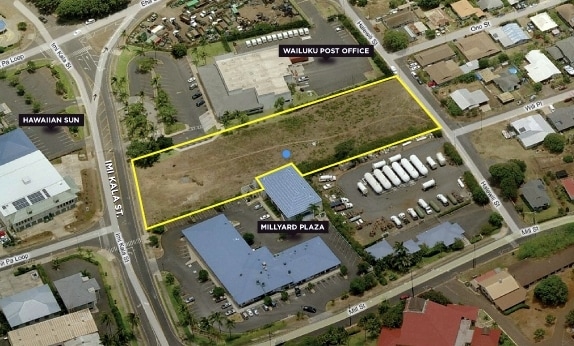
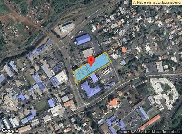
230 Imi Kala St, Wailuku, HI 96793

NEARBY LISTINGS FOR SALE OR LEASE
Property Detail
230 Imi Kala St
Kahului-Wailuku-Lahaina, HI
Millyard
2-3-4-020-078-0000
LOT 55-D MILLYARD SUBDIVISION FP 1829 POR GR 3343 RP 5531 LCAW 1742:4 66,979 SF DES TOG/ESMT SUBJ/ESMT & ESMT 7, 27, 12-A
Industrialgeneral
Maui
X
Hawaii
1500030391E
55-d
2024
1.54 AC
2025
Central Maui
030902
Hawaii
26,596 SF
DEMOGRAPHICS near 230 Imi Kala St
1 Mile
3 Mile
5 Mile
2024 Total Population
13,654
53,596
54,107
2029 Population
13,440
52,562
53,062
Pop Growth 2024-2029
(1.57%)
(1.93%)
(1.93%)
Average Age
41
40
40
2024 Total Households
4,470
15,522
15,661
HH Growth 2024-2029
(2.35%)
(2.56%)
(2.55%)
Median Household Inc
$63,923
$81,388
$81,449
Avg Household Size
2.90
3.20
3.20
2024 Avg HH Vehicles
2.00
2.00
2.00
Median Home Value
$610,034
$672,877
$672,336
Median Year Built
1979
1986
1986
Nearby Places
Map Layers
Map Styles
 Street
 Aerial
- Restaurants
- Banks
- Shops
- Fitness
- Groceries
PUBLIC TRANSPORTATION
AIRPORT
Kahului
DRIVE
WALK
Distance
Kahului
16 min
6.9 mi
Nearby Properties
Address
Land Use
TOTAL SIZE
Lot Size
Zoning
Address
Land Use
TOTAL SIZE
Lot Size
Zoning
14.34 AC
500
Address
Land Use
TOTAL SIZE
Lot Size
Zoning
191,252 SF
25.37 AC
420
Address
Land Use
TOTAL SIZE
Lot Size
Zoning
43,434 SF
13.89 AC
410
Address
Land Use
TOTAL SIZE
Lot Size
Zoning
130,920 SF
11.42 AC
Address
Land Use
TOTAL SIZE
Lot Size
Zoning
144,519 SF
12.99 AC
410
Address
Land Use
TOTAL SIZE
Lot Size
Zoning
103,221 SF
12.93 AC
720
Address
Land Use
TOTAL SIZE
Lot Size
Zoning
234,826 SF
14.36 AC
410
Address
Land Use
TOTAL SIZE
Lot Size
Zoning
5.11 AC
Address
Land Use
TOTAL SIZE
Lot Size
Zoning
19.54 AC
720
Address
Land Use
TOTAL SIZE
Lot Size
Zoning
72,457 SF
2.96 AC
320
Address
Land Use
TOTAL SIZE
Lot Size
Zoning
24,848 SF
11.41 AC
500
Address
Land Use
TOTAL SIZE
Lot Size
Zoning
552,589 SF
24.60 AC
420
Address
Land Use
TOTAL SIZE
Lot Size
Zoning
81,702 SF
4.40 AC
Address
Land Use
TOTAL SIZE
Lot Size
Zoning
72,377 SF
6.06 AC
720
Address
Land Use
TOTAL SIZE
Lot Size
Zoning
1.83 AC
Address
Land Use
TOTAL SIZE
Lot Size
Zoning
16.75 AC
320
Address
Land Use
TOTAL SIZE
Lot Size
Zoning
94,025 SF
0.84 AC
370
Address
Land Use
TOTAL SIZE
Lot Size
Zoning
69,340 SF
5.33 AC
320
Address
Land Use
TOTAL SIZE
Lot Size
Zoning
103,520 SF
4.50 AC
720
Address
Land Use
TOTAL SIZE
Lot Size
Zoning
2.01 AC
Address
Land Use
TOTAL SIZE
Lot Size
Zoning
42,501 SF
2.59 AC
420
Address
Land Use
TOTAL SIZE
Lot Size
Zoning
191,383 SF
12.82 AC
420
Address
Land Use
TOTAL SIZE
Lot Size
Zoning
82,080 SF
3.23 AC
320
Address
Land Use
TOTAL SIZE
Lot Size
Zoning
144,700 SF
7.69 AC
410
Address
Land Use
TOTAL SIZE
Lot Size
Zoning
Address
Land Use
TOTAL SIZE
Lot Size
Zoning
42,672 SF
4.50 AC
720
Address
Land Use
TOTAL SIZE
Lot Size
Zoning
117,800 SF
6.21 AC
420
Address
Land Use
TOTAL SIZE
Lot Size
Zoning
58,034 SF
1.56 AC
320
Address
Land Use
TOTAL SIZE
Lot Size
Zoning
10.52 AC
120
Address
Land Use
TOTAL SIZE
Lot Size
Zoning
53,632 SF
9.10 AC
420
The World's #1 Commercial Real Estate Marketplace
Connect with us
© 2025 CoStar Group
The information above has been obtained from sources believed reliable. While we do not doubt its accuracy we have not verified it and make no guarantee, warranty or representation about it. It is your responsibility to independently confirm its accuracy and completeness. Any projections, opinions, assumptions, or estimates used are for example only and do not represent the current or future performance of the property. The value of this transaction to you depends on tax and other factors which should be evaluated by your tax, financial, and legal advisors. You and your advisors should conduct a careful, independent investigation of the property to determine to your satisfaction the suitability of the property for your needs.