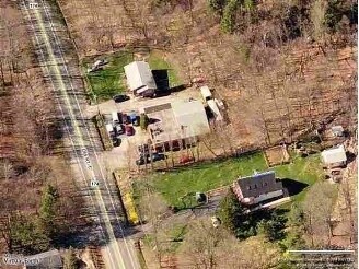
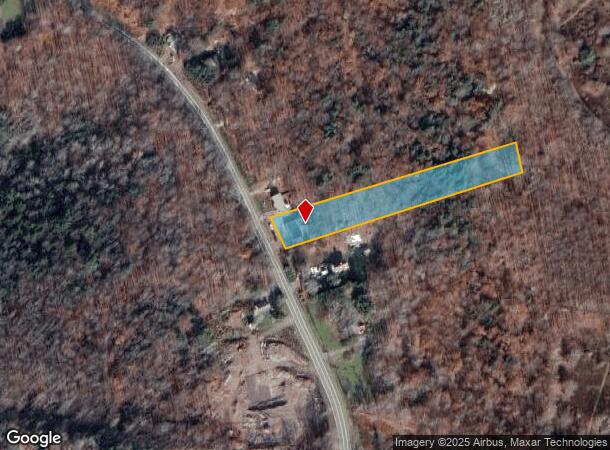
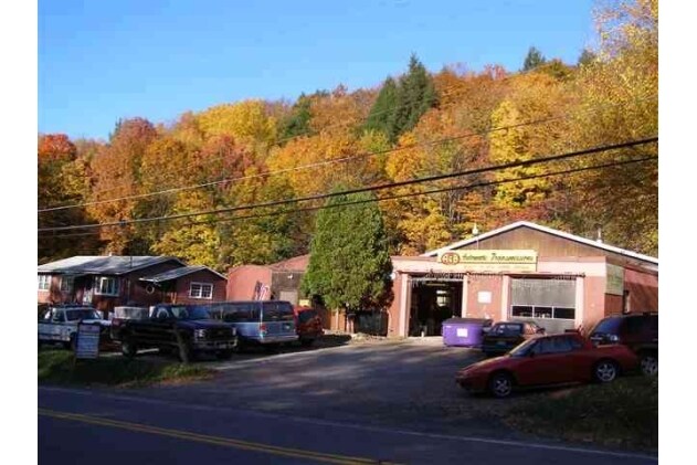
Property Record
230 Old Route 17, Monticello, NY 12701
NEARBY LISTINGS FOR SALE OR LEASE
-
-
-
No Photo
-
View all Monticello listings for sale on LoopNet.com
Property Detail
230 Old Route 17
Autorepair
Sullivan
X
New York
36105C0465F
16.002
2025
1.64 AC
2024
Hudson Valley Area
951500
Other Market Areas
3,328 SF
4689-012-0-0001-016-002
DEMOGRAPHICS near 230 Old Route 17
1 Mile
3 Mile
5 Mile
2024 Total Population
483
12,997
18,227
2029 Population
515
13,666
19,050
Pop Growth 2024-2029
+ 6.63%
+ 5.15%
+ 4.52%
Average Age
42
39
40
2024 Total Households
191
5,153
7,141
HH Growth 2024-2029
+ 7.85%
+ 5.51%
+ 4.90%
Median Household Inc
$56,874
$40,549
$44,339
Avg Household Size
2.20
2.30
2.40
2024 Avg HH Vehicles
2.00
1.00
2.00
Median Home Value
$140,000
$161,285
$179,575
Median Year Built
1982
1974
1974
Nearby Places
- Restaurants
- Banks
- Shops
- Fitness
- Groceries
SALE & LEASE HISTORY
LISTING DATE
SALE/LEASE

Sep 24, 2016
For Sale
Nearby Properties
Address
Land Use
TOTAL SIZE
Lot Size
Zoning
Address
Land Use
TOTAL SIZE
Lot Size
Zoning
154,000 SF
36.19 AC
B1
Address
Land Use
TOTAL SIZE
Lot Size
Zoning
286,801 SF
371.77 AC
SR
Address
Land Use
TOTAL SIZE
Lot Size
Zoning
218,139 SF
87.72 AC
HC2
Address
Land Use
TOTAL SIZE
Lot Size
Zoning
3,123 SF
48.30 AC
RR
Address
Land Use
TOTAL SIZE
Lot Size
Zoning
3,980 SF
46.93 AC
HC2 / RR2
Address
Land Use
TOTAL SIZE
Lot Size
Zoning
222,345 SF
165.77 AC
B1
Address
Land Use
TOTAL SIZE
Lot Size
Zoning
135,207 SF
83.50 AC
RM
Address
Land Use
TOTAL SIZE
Lot Size
Zoning
209,366 SF
32.32 AC
HC1
Address
Land Use
TOTAL SIZE
Lot Size
Zoning
100,167 SF
9.60 AC
BLI
Address
Land Use
TOTAL SIZE
Lot Size
Zoning
1,600 SF
72.96 AC
CI / RR1
Address
Land Use
TOTAL SIZE
Lot Size
Zoning
11,118 SF
56.49 AC
RR1
Address
Land Use
TOTAL SIZE
Lot Size
Zoning
17,812 SF
3.50 AC
RM
Address
Land Use
TOTAL SIZE
Lot Size
Zoning
48,976 SF
297.25 AC
SR
Address
Land Use
TOTAL SIZE
Lot Size
Zoning
Address
Land Use
TOTAL SIZE
Lot Size
Zoning
14,841 SF
17.19 AC
HC2
Address
Land Use
TOTAL SIZE
Lot Size
Zoning
104,739 SF
9.68 AC
HC2
Address
Land Use
TOTAL SIZE
Lot Size
Zoning
7,360 SF
32.43 AC
RR
Address
Land Use
TOTAL SIZE
Lot Size
Zoning
27,686 SF
13.23 AC
NC
Address
Land Use
TOTAL SIZE
Lot Size
Zoning
4,950 SF
56.24 AC
PRD
Address
Land Use
TOTAL SIZE
Lot Size
Zoning
54,525 SF
6.33 AC
HC
Address
Land Use
TOTAL SIZE
Lot Size
Zoning
4,480 SF
14.40 AC
RM
Address
Land Use
TOTAL SIZE
Lot Size
Zoning
5,694 SF
25.16 AC
RR
Address
Land Use
TOTAL SIZE
Lot Size
Zoning
19,392 SF
27.68 AC
HC2
Address
Land Use
TOTAL SIZE
Lot Size
Zoning
34,604 SF
9.14 AC
B1
Address
Land Use
TOTAL SIZE
Lot Size
Zoning
27,134 SF
10.73 AC
RR
Address
Land Use
TOTAL SIZE
Lot Size
Zoning
56,378 SF
13.65 AC
HC2
Address
Land Use
TOTAL SIZE
Lot Size
Zoning
10,787 SF
13.80 AC
HC
Address
Land Use
TOTAL SIZE
Lot Size
Zoning
55,365 SF
13.01 AC
HC2
Address
Land Use
TOTAL SIZE
Lot Size
Zoning
55,365 SF
9.33 AC
HC2
Address
Land Use
TOTAL SIZE
Lot Size
Zoning
39,176 SF
64.72 AC
SR
The World's #1 Commercial Real Estate Marketplace
Connect with us
© 2025 CoStar Group
The information above has been obtained from sources believed reliable. While we do not doubt its accuracy we have not verified it and make no guarantee, warranty or representation about it. It is your responsibility to independently confirm its accuracy and completeness. Any projections, opinions, assumptions, or estimates used are for example only and do not represent the current or future performance of the property. The value of this transaction to you depends on tax and other factors which should be evaluated by your tax, financial, and legal advisors. You and your advisors should conduct a careful, independent investigation of the property to determine to your satisfaction the suitability of the property for your needs.