Property Record
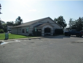
230 S Maple St, Grant, MI 49327

Property Detail
230 S Maple St
Medicalbuilding
W 5A OF N1/2 S1/2 NE1/4, EXC N 153 FT THEREOF, ALSO EXC COM AT SW COR THEREOF TH N ALG W LN NE1/4 425 FT, E PAR TO S LN
LOCAL ZONE
Newaygo
B and X Area of moderate flood hazard, usually the area between the limits of the 100-year and 500-year floods.
Michigan
2025
1.16 AC
2025
Newaygo County
971100
West Michigan
5,040 SF
22-24-251-004
NEARBY LISTINGS FOR SALE OR LEASE
-
-
View all Grant listings for sale on LoopNet.com
DEMOGRAPHICS near 230 S Maple St
1 mile
3 mile
5 mile
2025 Total Population
1,276
2,964
8,225
2030 Population
1,273
2,964
8,392
Pop Growth 2025-2030
(0.24%)
0.00%
+ 2.03%
Average Age
38
38
40
2025 Total Households
452
1,053
3,027
HH Growth 2025-2030
(0.44%)
(0.19%)
+ 2.08%
Median Household Inc
$74,999
$73,029
$72,560
Avg Household Size
2.80
2.70
2.70
2025 Avg HH Vehicles
2.00
2.00
2.00
Median Home Value
$193,928
$196,666
$241,492
Median Year Built
1977
1977
1981
Nearby Places
Map Layers
Map Styles
 Street
 Aerial
Transit
 Traffic
 Biking
Places
Listings with unknown addresses are not visible on the map
- Restaurants
- Banks
- Shops
- Fitness
- Groceries
SALE & LEASE HISTORY
LISTING DATE
SALE/LEASE

Sep 17, 2021
For Sale
Nearby Properties
Address
Land Use
TOTAL SIZE
Lot Size
Zoning
Address
Land Use
TOTAL SIZE
Lot Size
Zoning
40,368 SF
5.02 AC
LOCAL ZONE
Address
Land Use
TOTAL SIZE
Lot Size
Zoning
2,000 SF
35.85 AC
LOCAL ZONE
Address
Land Use
TOTAL SIZE
Lot Size
Zoning
28,341 SF
26.51 AC
LOCAL ZONE
Address
Land Use
TOTAL SIZE
Lot Size
Zoning
3,200 SF
0.49 AC
LOCAL ZONE
Address
Land Use
TOTAL SIZE
Lot Size
Zoning
20,348 SF
3.03 AC
LOCAL ZONE
Address
Land Use
TOTAL SIZE
Lot Size
Zoning
27,120 SF
4.50 AC
LOCAL ZONE
Address
Land Use
TOTAL SIZE
Lot Size
Zoning
4,077 SF
0.30 AC
LOCAL ZONE
Address
Land Use
TOTAL SIZE
Lot Size
Zoning
240 AC
LOCAL ZONE
Address
Land Use
TOTAL SIZE
Lot Size
Zoning
80 AC
LOCAL ZONE
Address
Land Use
TOTAL SIZE
Lot Size
Zoning
14,900 SF
4.91 AC
LOCAL ZONE
Address
Land Use
TOTAL SIZE
Lot Size
Zoning
23,634 SF
4.45 AC
LOCAL ZONE
Address
Land Use
TOTAL SIZE
Lot Size
Zoning
144.49 AC
LOCAL ZONE
Address
Land Use
TOTAL SIZE
Lot Size
Zoning
159 AC
LOCAL ZONE
Address
Land Use
TOTAL SIZE
Lot Size
Zoning
63.30 AC
LOCAL ZONE
Address
Land Use
TOTAL SIZE
Lot Size
Zoning
7,200 SF
2.22 AC
LOCAL ZONE
Address
Land Use
TOTAL SIZE
Lot Size
Zoning
59.20 AC
LOCAL ZONE
Address
Land Use
TOTAL SIZE
Lot Size
Zoning
3,600 SF
10 AC
C - 1
Address
Land Use
TOTAL SIZE
Lot Size
Zoning
44,604 SF
5.36 AC
LOCAL ZONE
Address
Land Use
TOTAL SIZE
Lot Size
Zoning
53,386 SF
9.21 AC
LOCAL ZONE
Address
Land Use
TOTAL SIZE
Lot Size
Zoning
120 AC
LOCAL ZONE
Address
Land Use
TOTAL SIZE
Lot Size
Zoning
7,076 SF
0.31 AC
LOCAL ZONE
Address
Land Use
TOTAL SIZE
Lot Size
Zoning
15,216 SF
1.17 AC
LOCAL ZONE
Address
Land Use
TOTAL SIZE
Lot Size
Zoning
141.70 AC
LOCAL ZONE
Address
Land Use
TOTAL SIZE
Lot Size
Zoning
9,069 SF
1.10 AC
LOCAL ZONE
Address
Land Use
TOTAL SIZE
Lot Size
Zoning
2,440 SF
1 AC
LOCAL ZONE
Address
Land Use
TOTAL SIZE
Lot Size
Zoning
Address
Land Use
TOTAL SIZE
Lot Size
Zoning
80 AC
LOCAL ZONE
Address
Land Use
TOTAL SIZE
Lot Size
Zoning
14,840 SF
1.87 AC
R1
The World's #1 Commercial Real Estate Marketplace
Connect with us
© 2026 CoStar Group
The information above has been obtained from sources believed reliable. While we do not doubt its accuracy we have not verified it and make no guarantee, warranty or representation about it. It is your responsibility to independently confirm its accuracy and completeness. Any projections, opinions, assumptions, or estimates used are for example only and do not represent the current or future performance of the property. The value of this transaction to you depends on tax and other factors which should be evaluated by your tax, financial, and legal advisors. You and your advisors should conduct a careful, independent investigation of the property to determine to your satisfaction the suitability of the property for your needs.