Property Record
230 Shaker Rd, Enfield, CT 06082
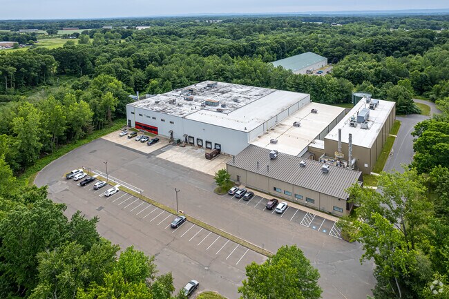

Property Detail
230 Shaker Rd
ENFI-000094-000000-000008
Capitol
Industrialgeneral
Connecticut
I-1
8
AE The base floodplain where base flood elevations are provided. AE Zones are now used on new format FIRMs instead of A1-A30 Zones.
25.39 AC
2025
Enfield
2025
Hartford
524300
Hartford-West Hartford-East Hartford, CT
75,072 SF
NEARBY LISTINGS FOR SALE OR LEASE
DEMOGRAPHICS near 230 Shaker Rd
1 mile
3 mile
5 mile
2025 Total Population
790
27,347
84,420
2030 Population
812
27,873
85,671
Pop Growth 2025-2030
+ 2.78%
+ 1.92%
+ 1.48%
Average Age
44
44
43
2025 Total Households
286
10,464
32,683
HH Growth 2025-2030
+ 3.15%
+ 2.03%
+ 1.55%
Median Household Inc
$116,666
$103,497
$99,160
Avg Household Size
2.30
2.40
2.40
2025 Avg HH Vehicles
2.00
2.00
2.00
Median Home Value
$248,584
$288,048
$316,961
Median Year Built
1962
1964
1962
Nearby Places
Map Layers
Map Styles
 Street
 Aerial
Layers
 Traffic
 Biking
Places
Listings with unknown addresses are not visible on the map
- Restaurants
- Banks
- Shops
- Fitness
- Groceries
PUBLIC TRANSPORTATION
AIRPORT
Bradley International
Drive
Walk
Distance
Bradley International
30 min
12.1 mi
Freight Ports
Port of New Haven
Drive
Walk
Distance
Port of New Haven
80 min
60.3 mi
SALE & LEASE HISTORY
LISTING DATE
SALE/LEASE

Mar 08, 2020
For Lease
Nearby Properties
Address
Land Use
TOTAL SIZE
Lot Size
Zoning
Address
Land Use
TOTAL SIZE
Lot Size
Zoning
750,000 SF
405 AC
A-1
Address
Land Use
TOTAL SIZE
Lot Size
Zoning
69.62 AC
MFHD
Address
Land Use
TOTAL SIZE
Lot Size
Zoning
226,545 SF
14 AC
A-1
Address
Land Use
TOTAL SIZE
Lot Size
Zoning
370.78 AC
R88
Address
Land Use
TOTAL SIZE
Lot Size
Zoning
283.30 AC
R88
Address
Land Use
TOTAL SIZE
Lot Size
Zoning
166,268 SF
36.70 AC
R44
Address
Land Use
TOTAL SIZE
Lot Size
Zoning
142,872 SF
57.41 AC
INDG
Address
Land Use
TOTAL SIZE
Lot Size
Zoning
500,000 SF
71.20 AC
I-1
Address
Land Use
TOTAL SIZE
Lot Size
Zoning
121.07 AC
I-1
Address
Land Use
TOTAL SIZE
Lot Size
Zoning
49.16 AC
I-1
Address
Land Use
TOTAL SIZE
Lot Size
Zoning
36.97 AC
I-1
Address
Land Use
TOTAL SIZE
Lot Size
Zoning
211,256 SF
41.58 AC
R33
Address
Land Use
TOTAL SIZE
Lot Size
Zoning
121 AC
A-1
Address
Land Use
TOTAL SIZE
Lot Size
Zoning
57,328 SF
11.15 AC
INDG
Address
Land Use
TOTAL SIZE
Lot Size
Zoning
24.92 AC
BL
Address
Land Use
TOTAL SIZE
Lot Size
Zoning
13.87 AC
BR
Address
Land Use
TOTAL SIZE
Lot Size
Zoning
103,324 SF
20.47 AC
RA1
Address
Land Use
TOTAL SIZE
Lot Size
Zoning
13.78 AC
BR
Address
Land Use
TOTAL SIZE
Lot Size
Zoning
1.87 AC
BP
Address
Land Use
TOTAL SIZE
Lot Size
Zoning
19.36 AC
BR
Address
Land Use
TOTAL SIZE
Lot Size
Zoning
144,625 SF
19 AC
BR
Address
Land Use
TOTAL SIZE
Lot Size
Zoning
23,660 SF
9.28 AC
RA1
Address
Land Use
TOTAL SIZE
Lot Size
Zoning
259,093 SF
27.01 AC
INDG
Address
Land Use
TOTAL SIZE
Lot Size
Zoning
17.34 AC
R44
Address
Land Use
TOTAL SIZE
Lot Size
Zoning
91,735 SF
9.28 AC
RA1
Address
Land Use
TOTAL SIZE
Lot Size
Zoning
106,227 SF
9.76 AC
RA
Address
Land Use
TOTAL SIZE
Lot Size
Zoning
54.05 AC
I-1
Address
Land Use
TOTAL SIZE
Lot Size
Zoning
106,719 SF
3.76 AC
BR
Address
Land Use
TOTAL SIZE
Lot Size
Zoning
111,890 SF
22.08 AC
INDG
Address
Land Use
TOTAL SIZE
Lot Size
Zoning
172,241 SF
11.21 AC
INDG
The World's #1 Commercial Real Estate Marketplace
Connect with us
© 2026 CoStar Group
The information above has been obtained from sources believed reliable. While we do not doubt its accuracy we have not verified it and make no guarantee, warranty or representation about it. It is your responsibility to independently confirm its accuracy and completeness. Any projections, opinions, assumptions, or estimates used are for example only and do not represent the current or future performance of the property. The value of this transaction to you depends on tax and other factors which should be evaluated by your tax, financial, and legal advisors. You and your advisors should conduct a careful, independent investigation of the property to determine to your satisfaction the suitability of the property for your needs.