Property Record
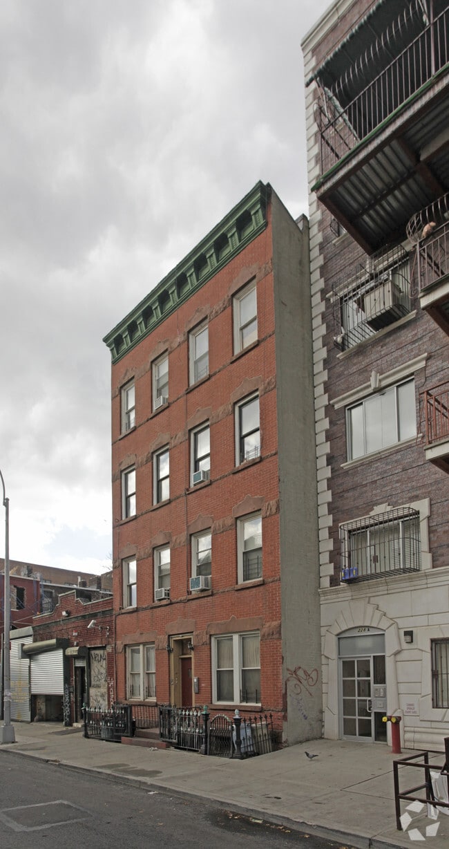
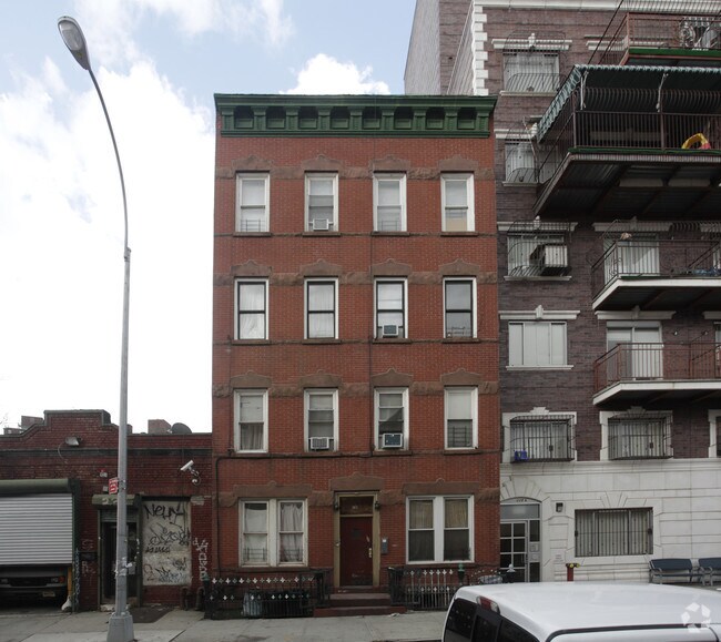
230 Skillman St, Brooklyn, NY 11205

Property Detail
230 Skillman St
01927-0059
DOCID-2018032700538002
Multifamilydwelling
Kings
R6B
New York
B and X Area of moderate flood hazard, usually the area between the limits of the 100-year and 500-year floods.
59
2024
0.06 AC
2025
Bedford-Stuyvesant
023500
Long Island (New York)
5,856 SF
New York-Jersey City-White Plains, NY-NJ
NEARBY LISTINGS FOR SALE OR LEASE
DEMOGRAPHICS near 230 Skillman St
1 mile
3 mile
5 mile
2025 Total Population
198,128
1,377,878
2,964,601
2030 Population
199,592
1,391,657
2,984,240
Pop Growth 2025-2030
+ 0.74%
+ 1.00%
+ 0.66%
Average Age
34
38
39
2025 Total Households
71,074
559,757
1,192,299
HH Growth 2025-2030
+ 0.28%
+ 0.90%
+ 1.10%
Median Household Inc
$84,368
$91,389
$94,796
Avg Household Size
2.60
2.30
2.30
2025 Avg HH Vehicles
.00
.00
.00
Median Home Value
$1,010,745
$1,023,380
$931,161
Median Year Built
1949
1948
1949
Nearby Places
Map Layers
Map Styles
 Street
 Aerial
Layers
 Traffic
 Biking
Places
Listings with unknown addresses are not visible on the map
- Restaurants
- Banks
- Shops
- Fitness
- Groceries
PUBLIC TRANSPORTATION
TRANSIT/SUBWAY
Bedford-Nostrand Avenues (G - New York MTA Subway (The Subway))
Drive
Walk
Distance
Bedford-Nostrand Avenues (G - New York MTA Subway (The Subway))
3 min
5 min
0.3 mi
Classon Avenue (G - New York MTA Subway (The Subway))
Drive
Walk
Distance
Classon Avenue (G - New York MTA Subway (The Subway))
3 min
6 min
0.3 mi
Myrtle-Willoughby Avenues (G - New York MTA Subway (The Subway))
Drive
Walk
Distance
Myrtle-Willoughby Avenues (G - New York MTA Subway (The Subway))
2 min
11 min
0.6 mi
Clinton-Washington Avenues (G Line) (G - New York MTA Subway (The Subway))
Drive
Walk
Distance
Clinton-Washington Avenues (G Line) (G - New York MTA Subway (The Subway))
4 min
13 min
0.7 mi
Franklin Avenue (A,C,S Line) (A - New York MTA Subway (The Subway), C - New York MTA Subway (The Subway), Franklin Avenue Shuttle - New York MTA Subway (The Subway))
Drive
Walk
Distance
Franklin Avenue (A,C,S Line) (A - New York MTA Subway (The Subway), C - New York MTA Subway (The Subway), Franklin Avenue Shuttle - New York MTA Subway (The Subway))
4 min
15 min
0.8 mi
COMMUTER RAIL
Nostrand Avenue Station (Far Rockaway Branch - Long Island Rail Road, Hempstead Branch - Long Island Rail Road, Long Beach Branch - Long Island Rail Road, West Hempstead Branch - Long Island Rail Road)
Drive
Walk
Distance
Nostrand Avenue Station (Far Rockaway Branch - Long Island Rail Road, Hempstead Branch - Long Island Rail Road, Long Beach Branch - Long Island Rail Road, West Hempstead Branch - Long Island Rail Road)
5 min
1.5 mi
Drive
Walk
Distance
7 min
2.2 mi
AIRPORT
LaGuardia
Drive
Walk
Distance
LaGuardia
17 min
8.7 mi
John F Kennedy International
Drive
Walk
Distance
John F Kennedy International
27 min
11.9 mi
Newark Liberty International
Drive
Walk
Distance
Newark Liberty International
29 min
15.9 mi
Freight Ports
NY - Red Hook Container Terminal
Drive
Walk
Distance
NY - Red Hook Container Terminal
10 min
4.1 mi
Nearby Properties
Address
Land Use
TOTAL SIZE
Lot Size
Zoning
Address
Land Use
TOTAL SIZE
Lot Size
Zoning
2,812,739 SF
2.10 AC
C5-3
Address
Land Use
TOTAL SIZE
Lot Size
Zoning
1,104,505 SF
2.32 AC
C4-7
Address
Land Use
TOTAL SIZE
Lot Size
Zoning
7,058,736 SF
147.61 AC
M3-1
Address
Land Use
TOTAL SIZE
Lot Size
Zoning
869,038 SF
1.53 AC
M1-1
Address
Land Use
TOTAL SIZE
Lot Size
Zoning
2,210,200 SF
2.58 AC
C5-5
Address
Land Use
TOTAL SIZE
Lot Size
Zoning
1,653,794 SF
3.15 AC
C6-4
Address
Land Use
TOTAL SIZE
Lot Size
Zoning
1,617,206 SF
1.23 AC
C5-5
Address
Land Use
TOTAL SIZE
Lot Size
Zoning
1,503,150 SF
20.47 AC
R5
Address
Land Use
TOTAL SIZE
Lot Size
Zoning
1,075,808 SF
1.12 AC
C5-5
Address
Land Use
TOTAL SIZE
Lot Size
Zoning
393.54 AC
PARK
Address
Land Use
TOTAL SIZE
Lot Size
Zoning
2,948,300 SF
27.71 AC
R7-2
Address
Land Use
TOTAL SIZE
Lot Size
Zoning
577,381 SF
3.19 AC
R6
Address
Land Use
TOTAL SIZE
Lot Size
Zoning
890,142 SF
2.22 AC
R7-1
Address
Land Use
TOTAL SIZE
Lot Size
Zoning
1,079,361 SF
1.07 AC
C5-3
Address
Land Use
TOTAL SIZE
Lot Size
Zoning
943,802 SF
0.97 AC
C6-9
Address
Land Use
TOTAL SIZE
Lot Size
Zoning
1,258,851 SF
2.20 AC
C6-4
Address
Land Use
TOTAL SIZE
Lot Size
Zoning
1,658,649 SF
15.93 AC
R7-2
Address
Land Use
TOTAL SIZE
Lot Size
Zoning
830,879 SF
1 AC
C5-4
Address
Land Use
TOTAL SIZE
Lot Size
Zoning
1,106,962 SF
3.98 AC
C6-4
Address
Land Use
TOTAL SIZE
Lot Size
Zoning
835,231 SF
11.32 AC
R6
Address
Land Use
TOTAL SIZE
Lot Size
Zoning
1,021,351 SF
1.24 AC
C5-5
Address
Land Use
TOTAL SIZE
Lot Size
Zoning
813,363 SF
3.50 AC
C6-4
Address
Land Use
TOTAL SIZE
Lot Size
Zoning
990,250 SF
1.12 AC
C6-9
Address
Land Use
TOTAL SIZE
Lot Size
Zoning
1,061,228 SF
8.86 AC
R5
Address
Land Use
TOTAL SIZE
Lot Size
Zoning
1,007,569 SF
0.98 AC
C5-5
Address
Land Use
TOTAL SIZE
Lot Size
Zoning
579,404 SF
4.80 AC
R6
Address
Land Use
TOTAL SIZE
Lot Size
Zoning
1,056,600 SF
1.15 AC
C6-4
Address
Land Use
TOTAL SIZE
Lot Size
Zoning
1,073,000 SF
1.36 AC
C5-5
Address
Land Use
TOTAL SIZE
Lot Size
Zoning
512,755 SF
1.19 AC
R6
Address
Land Use
TOTAL SIZE
Lot Size
Zoning
879,916 SF
1.35 AC
C6-4
The World's #1 Commercial Real Estate Marketplace
Connect with us
© 2026 CoStar Group
The information above has been obtained from sources believed reliable. While we do not doubt its accuracy we have not verified it and make no guarantee, warranty or representation about it. It is your responsibility to independently confirm its accuracy and completeness. Any projections, opinions, assumptions, or estimates used are for example only and do not represent the current or future performance of the property. The value of this transaction to you depends on tax and other factors which should be evaluated by your tax, financial, and legal advisors. You and your advisors should conduct a careful, independent investigation of the property to determine to your satisfaction the suitability of the property for your needs.