Property Record
2300 145Th St, Little Rock, AR 72206
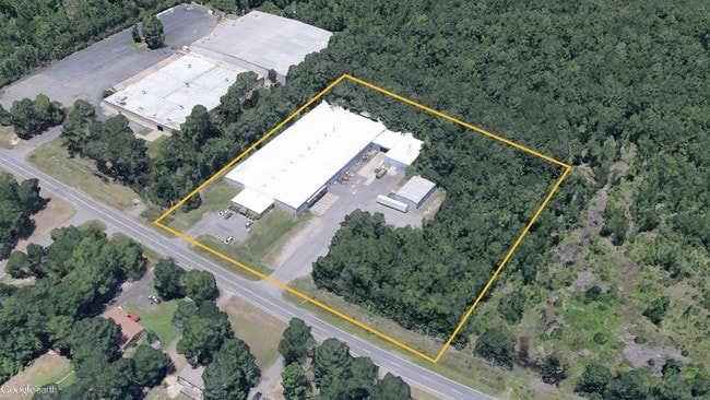
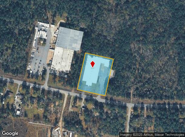

This Property Is For Sale
Current Lease Availabilities
NEARBY LISTINGS FOR SALE OR LEASE
-
-
View all Little Rock listings for sale on LoopNet.com
Property Detail
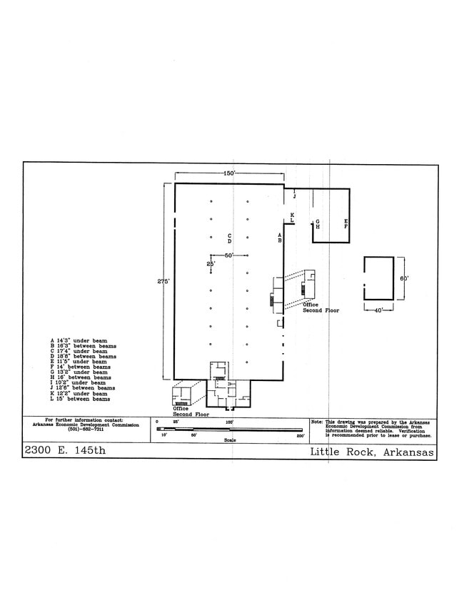
2300 145Th St
35R-024-00-014-07
PT NE SW & NW SE SECTION 24-1S-12 MPDA COM AT THE INTERSECTION OF THE N R/W LN PRATT ROAD (E 145TH ST) & W R/W LN DINEEN DR TH S89*44'40"E AL SAID N R/W LN 22.75' TH SE'LY & CONTINUING AL SAID N R/W TO A CURVE TO
Warehouse
Pulaski
X
Arkansas
05125C0425E
2.76 AC
2025
Outlying Pulaski County
2025
Little Rock/N Little Rock
004007
Little Rock-North Little Rock-Conway, AR
49,150 SF
DEMOGRAPHICS near 2300 145Th St
1 Mile
3 Mile
5 Mile
2024 Total Population
343
4,634
13,186
2029 Population
348
4,726
13,502
Pop Growth 2024-2029
+ 1.46%
+ 1.99%
+ 2.40%
Average Age
42
44
42
2024 Total Households
141
1,904
5,243
HH Growth 2024-2029
+ 1.42%
+ 2.05%
+ 2.44%
Median Household Inc
$48,888
$44,439
$50,057
Avg Household Size
2.40
2.40
2.40
2024 Avg HH Vehicles
2.00
2.00
2.00
Median Home Value
$106,452
$115,126
$133,566
Median Year Built
1989
1982
1981
Nearby Places
Map Layers
Map Styles
 Street
 Aerial
- Restaurants
- Banks
- Shops
- Fitness
- Groceries
PUBLIC TRANSPORTATION
AIRPORT
Bill and Hillary Clinton Ntl/Adams Field
DRIVE
WALK
Distance
Bill and Hillary Clinton Ntl/Adams Field
15 min
11.0 mi
Nearby Properties
Address
Land Use
TOTAL SIZE
Lot Size
Zoning
Address
Land Use
TOTAL SIZE
Lot Size
Zoning
55,632 SF
49.68 AC
Address
Land Use
TOTAL SIZE
Lot Size
Zoning
38,125 SF
23.40 AC
Address
Land Use
TOTAL SIZE
Lot Size
Zoning
30,261 SF
70 AC
Address
Land Use
TOTAL SIZE
Lot Size
Zoning
48,000 SF
11.67 AC
Address
Land Use
TOTAL SIZE
Lot Size
Zoning
23,200 SF
33.98 AC
Address
Land Use
TOTAL SIZE
Lot Size
Zoning
24,800 SF
13.07 AC
Address
Land Use
TOTAL SIZE
Lot Size
Zoning
7,360 SF
8.75 AC
Address
Land Use
TOTAL SIZE
Lot Size
Zoning
12.86 AC
Address
Land Use
TOTAL SIZE
Lot Size
Zoning
25,466 SF
8 AC
Address
Land Use
TOTAL SIZE
Lot Size
Zoning
3,696 SF
1.46 AC
Address
Land Use
TOTAL SIZE
Lot Size
Zoning
5,748 SF
14.91 AC
Address
Land Use
TOTAL SIZE
Lot Size
Zoning
9,000 SF
1.04 AC
Address
Land Use
TOTAL SIZE
Lot Size
Zoning
48,000 SF
11.80 AC
Address
Land Use
TOTAL SIZE
Lot Size
Zoning
34,500 SF
71.68 AC
Address
Land Use
TOTAL SIZE
Lot Size
Zoning
10,004 SF
9.46 AC
Address
Land Use
TOTAL SIZE
Lot Size
Zoning
4,788 SF
3 AC
Address
Land Use
TOTAL SIZE
Lot Size
Zoning
167.50 AC
Address
Land Use
TOTAL SIZE
Lot Size
Zoning
1,248 SF
80 AC
Address
Land Use
TOTAL SIZE
Lot Size
Zoning
7,256 SF
146.23 AC
Address
Land Use
TOTAL SIZE
Lot Size
Zoning
20,000 SF
1.32 AC
Address
Land Use
TOTAL SIZE
Lot Size
Zoning
2,696 SF
40 AC
Address
Land Use
TOTAL SIZE
Lot Size
Zoning
4,000 SF
4.74 AC
Address
Land Use
TOTAL SIZE
Lot Size
Zoning
10,782 SF
4.34 AC
Address
Land Use
TOTAL SIZE
Lot Size
Zoning
6,250 SF
5.52 AC
Address
Land Use
TOTAL SIZE
Lot Size
Zoning
4,600 SF
11.91 AC
Address
Land Use
TOTAL SIZE
Lot Size
Zoning
2,640 SF
17.78 AC
Address
Land Use
TOTAL SIZE
Lot Size
Zoning
2,600 SF
1.84 AC
Address
Land Use
TOTAL SIZE
Lot Size
Zoning
6,188 SF
14.39 AC
Address
Land Use
TOTAL SIZE
Lot Size
Zoning
11,700 SF
11.75 AC
The World's #1 Commercial Real Estate Marketplace
Connect with us
© 2026 CoStar Group
The information above has been obtained from sources believed reliable. While we do not doubt its accuracy we have not verified it and make no guarantee, warranty or representation about it. It is your responsibility to independently confirm its accuracy and completeness. Any projections, opinions, assumptions, or estimates used are for example only and do not represent the current or future performance of the property. The value of this transaction to you depends on tax and other factors which should be evaluated by your tax, financial, and legal advisors. You and your advisors should conduct a careful, independent investigation of the property to determine to your satisfaction the suitability of the property for your needs.