Property Record
2300 Glendale Blvd, Moapa, NV 89025
Save to a Folder
{{folder.Name}}
{{folder.ListingIds.length}} Properties
{{folder.ListingIds.length}} Property
Create a New Folder
Property Detail
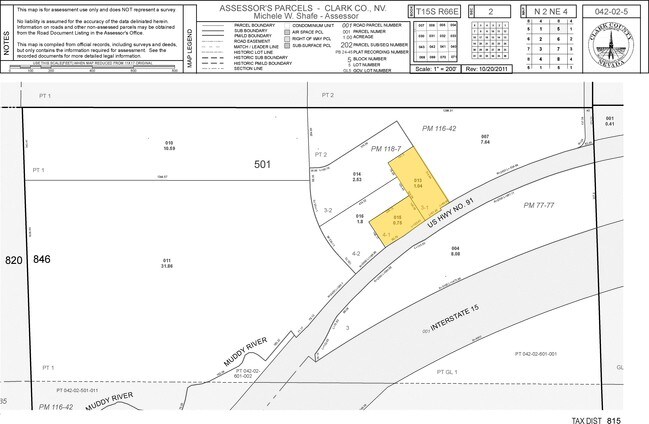
2300 Glendale Blvd
042-02-501-013
PARCEL MAP FILE 118 PAGE 7 LOT 3-1
Restaurantbuilding
CLARK
C2
Nevada
C and X Area of minimal flood hazard, usually depicted on FIRMs as above the 500-year flood level.
3
2026
1.04 AC
2026
Outlying NE Clark County
005902
Las Vegas
7,179 SF
Las Vegas-Henderson-North Las Vegas, NV
NEARBY LISTINGS FOR SALE OR LEASE
DEMOGRAPHICS near 2300 Glendale Blvd
1 mile
3 mile
5 mile
2025 Total Population
202
512
731
2030 Population
200
508
721
Pop Growth 2025-2030
(0.99%)
(0.78%)
(1.37%)
Average Age
39
39
40
2025 Total Households
65
164
242
HH Growth 2025-2030
(1.54%)
(0.61%)
(1.24%)
Median Household Inc
$71,249
$68,999
$61,125
Avg Household Size
3.10
3.10
3.00
2025 Avg HH Vehicles
3.00
3.00
2.00
Median Home Value
$363,636
$361,206
$356,521
Median Year Built
1993
1993
1990
Nearby Places
Map Layers
Map Styles
 Street
 Aerial
Layers
 Traffic
 Biking
Places
Listings with unknown addresses are not visible on the map
- Restaurants
- Banks
- Shops
- Fitness
- Groceries
Nearby Properties
Address
Land Use
TOTAL SIZE
Lot Size
Zoning
Address
Land Use
TOTAL SIZE
Lot Size
Zoning
12.50 AC
RU
Address
Land Use
TOTAL SIZE
Lot Size
Zoning
7,511 SF
8.89 AC
C2
Address
Land Use
TOTAL SIZE
Lot Size
Zoning
17,136 SF
9.55 AC
PF
Address
Land Use
TOTAL SIZE
Lot Size
Zoning
14,960 SF
2.54 AC
RU
Address
Land Use
TOTAL SIZE
Lot Size
Zoning
38,275 SF
8.34 AC
M1
Address
Land Use
TOTAL SIZE
Lot Size
Zoning
1,784 SF
160 AC
RA
Address
Land Use
TOTAL SIZE
Lot Size
Zoning
8,482 SF
5.04 AC
M1
Address
Land Use
TOTAL SIZE
Lot Size
Zoning
13,336 SF
31.49 AC
RA
Address
Land Use
TOTAL SIZE
Lot Size
Zoning
21,611 SF
88.17 AC
RA
Address
Land Use
TOTAL SIZE
Lot Size
Zoning
79.79 AC
RA
Address
Land Use
TOTAL SIZE
Lot Size
Zoning
359.29 AC
RU
Address
Land Use
TOTAL SIZE
Lot Size
Zoning
4,187 SF
17.29 AC
RU
Address
Land Use
TOTAL SIZE
Lot Size
Zoning
4,724 SF
1.19 AC
C2
Address
Land Use
TOTAL SIZE
Lot Size
Zoning
2,010 SF
1.60 AC
C2
Address
Land Use
TOTAL SIZE
Lot Size
Zoning
40.34 AC
RA
Address
Land Use
TOTAL SIZE
Lot Size
Zoning
40 AC
RU
Address
Land Use
TOTAL SIZE
Lot Size
Zoning
3.49 AC
RU
Address
Land Use
TOTAL SIZE
Lot Size
Zoning
3,710 SF
0.70 AC
C2
The World's #1 Commercial Real Estate Marketplace
Connect with us
© 2026 CoStar Group
The information above has been obtained from sources believed reliable. While we do not doubt its accuracy we have not verified it and make no guarantee, warranty or representation about it. It is your responsibility to independently confirm its accuracy and completeness. Any projections, opinions, assumptions, or estimates used are for example only and do not represent the current or future performance of the property. The value of this transaction to you depends on tax and other factors which should be evaluated by your tax, financial, and legal advisors. You and your advisors should conduct a careful, independent investigation of the property to determine to your satisfaction the suitability of the property for your needs.