Property Record
2300 Hammonds Ferry Rd, Halethorpe, MD 21227


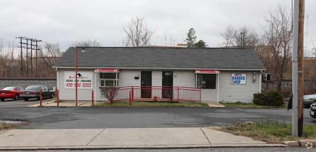
Property Detail
2300 Hammonds Ferry Rd
13-1308000300
1 AC
Storebuilding
Baltimore
ML
Maryland
B and X Area of moderate flood hazard, usually the area between the limits of the 100-year and 500-year floods.
152
2024
1 AC
2025
BWI/Baltimore County
430200
Baltimore
1,440 SF
Baltimore-Columbia-Towson, MD
NEARBY LISTINGS FOR SALE OR LEASE
DEMOGRAPHICS near 2300 Hammonds Ferry Rd
1 mile
3 mile
5 mile
2025 Total Population
10,431
118,650
373,108
2030 Population
10,372
118,873
373,859
Pop Growth 2025-2030
(0.57%)
+ 0.19%
+ 0.20%
Average Age
37
38
39
2025 Total Households
3,743
44,686
157,371
HH Growth 2025-2030
(0.53%)
(0.04%)
0.00%
Median Household Inc
$57,989
$60,029
$64,732
Avg Household Size
2.70
2.50
2.30
2025 Avg HH Vehicles
1.00
1.00
1.00
Median Home Value
$238,219
$237,758
$275,763
Median Year Built
1957
1954
1954
Nearby Places
Map Layers
Map Styles
 Street
 Aerial
Layers
 Traffic
 Biking
Places
Listings with unknown addresses are not visible on the map
- Restaurants
- Banks
- Shops
- Fitness
- Groceries
PUBLIC TRANSPORTATION
COMMUTER RAIL
Halethorpe Marc Nb (PENN - WASHINGTON - Maryland Transit Administration)
Drive
Walk
Distance
Halethorpe Marc Nb (PENN - WASHINGTON - Maryland Transit Administration)
6 min
2.7 mi
Halethorpe Marc Sb (PENN - WASHINGTON - Maryland Transit Administration)
Drive
Walk
Distance
Halethorpe Marc Sb (PENN - WASHINGTON - Maryland Transit Administration)
6 min
2.7 mi
AIRPORT
Baltimore/Washington International Thurgood Marshall
Drive
Walk
Distance
Baltimore/Washington International Thurgood Marshall
13 min
6.8 mi
Freight Ports
Port of Baltimore
Drive
Walk
Distance
Port of Baltimore
12 min
5.1 mi
Nearby Properties
Address
Land Use
TOTAL SIZE
Lot Size
Zoning
Address
Land Use
TOTAL SIZE
Lot Size
Zoning
20.26 AC
C-5DC
Address
Land Use
TOTAL SIZE
Lot Size
Zoning
308,887 SF
3.98 AC
C-5DC
Address
Land Use
TOTAL SIZE
Lot Size
Zoning
1,396,807 SF
32.73 AC
R-6
Address
Land Use
TOTAL SIZE
Lot Size
Zoning
2,182,087 SF
95.52 AC
DR5.5
Address
Land Use
TOTAL SIZE
Lot Size
Zoning
520,407 SF
16.85 AC
H
Address
Land Use
TOTAL SIZE
Lot Size
Zoning
309,558 SF
3.01 AC
C-2
Address
Land Use
TOTAL SIZE
Lot Size
Zoning
442,145 SF
2.30 AC
C-2
Address
Land Use
TOTAL SIZE
Lot Size
Zoning
523,800 SF
28.02 AC
I-1
Address
Land Use
TOTAL SIZE
Lot Size
Zoning
1,105,167 SF
6.35 AC
C-5DC
Address
Land Use
TOTAL SIZE
Lot Size
Zoning
315,055 SF
9.60 AC
ML
Address
Land Use
TOTAL SIZE
Lot Size
Zoning
1,308,804 SF
16.24 AC
I-MU
Address
Land Use
TOTAL SIZE
Lot Size
Zoning
18.86 AC
DR16
Address
Land Use
TOTAL SIZE
Lot Size
Zoning
73,080 SF
6.34 AC
C-5DC
Address
Land Use
TOTAL SIZE
Lot Size
Zoning
184,317 SF
16.23 AC
MH
Address
Land Use
TOTAL SIZE
Lot Size
Zoning
41.14 AC
W1-BW
Address
Land Use
TOTAL SIZE
Lot Size
Zoning
40.17 AC
DR16
Address
Land Use
TOTAL SIZE
Lot Size
Zoning
300,513 SF
32.53 AC
I-1
Address
Land Use
TOTAL SIZE
Lot Size
Zoning
15.05 AC
R15
Address
Land Use
TOTAL SIZE
Lot Size
Zoning
48,300 SF
30.96 AC
ML
Address
Land Use
TOTAL SIZE
Lot Size
Zoning
116,600 SF
8.97 AC
C4
Address
Land Use
TOTAL SIZE
Lot Size
Zoning
197,754 SF
12.63 AC
DR5.5
Address
Land Use
TOTAL SIZE
Lot Size
Zoning
101,220 SF
17.51 AC
DR5.5
Address
Land Use
TOTAL SIZE
Lot Size
Zoning
194,652 SF
20.49 AC
W1-BW
Address
Land Use
TOTAL SIZE
Lot Size
Zoning
19.86 AC
DR16
Address
Land Use
TOTAL SIZE
Lot Size
Zoning
21.46 AC
ML
Address
Land Use
TOTAL SIZE
Lot Size
Zoning
86,587 SF
9.86 AC
W1-BW
Address
Land Use
TOTAL SIZE
Lot Size
Zoning
132,000 SF
29.26 AC
ML
Address
Land Use
TOTAL SIZE
Lot Size
Zoning
590,745 SF
52.60 AC
OS
Address
Land Use
TOTAL SIZE
Lot Size
Zoning
14.91 AC
DR16
Address
Land Use
TOTAL SIZE
Lot Size
Zoning
210,000 SF
11.11 AC
MH
The World's #1 Commercial Real Estate Marketplace
Connect with us
© 2026 CoStar Group
The information above has been obtained from sources believed reliable. While we do not doubt its accuracy we have not verified it and make no guarantee, warranty or representation about it. It is your responsibility to independently confirm its accuracy and completeness. Any projections, opinions, assumptions, or estimates used are for example only and do not represent the current or future performance of the property. The value of this transaction to you depends on tax and other factors which should be evaluated by your tax, financial, and legal advisors. You and your advisors should conduct a careful, independent investigation of the property to determine to your satisfaction the suitability of the property for your needs.