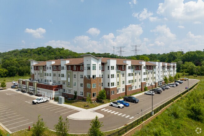
Property Record
2300 Hastings Ave, Newport, MN 55055


NEARBY LISTINGS FOR SALE OR LEASE
-
-
View all Newport listings for lease on LoopNet.com
Property Detail
2300 Hastings Ave
25-028-22-32-0035
Red Rock Park
Apartment
(CONTINUED FROM ABOVE) THENCE SOUTH 00 DEGREES 12 MINUTES 51 SECONDS EAST FOR A DISTANCE OF 195.40 FEET; THENCE NORTH 89 DEGR
X
Washington
27037C0044E
Minnesota
2025
10.79 AC
2024
Newport
071003
Minneapolis/St Paul
71,164 SF
Minneapolis-St. Paul-Bloomington, MN-WI
DEMOGRAPHICS near 2300 Hastings Ave
1 Mile
3 Mile
5 Mile
2024 Total Population
3,456
54,220
177,380
2029 Population
3,841
56,575
185,817
Pop Growth 2024-2029
+ 11.14%
+ 4.34%
+ 4.76%
Average Age
39
40
39
2024 Total Households
1,345
21,341
68,240
HH Growth 2024-2029
+ 11.38%
+ 4.44%
+ 4.66%
Median Household Inc
$67,994
$83,056
$84,688
Avg Household Size
2.60
2.50
2.50
2024 Avg HH Vehicles
2.00
2.00
2.00
Median Home Value
$384,677
$289,034
$308,306
Median Year Built
1978
1980
1982
Nearby Places
Map Layers
Map Styles
 Street
 Aerial
- Restaurants
- Banks
- Shops
- Fitness
- Groceries
PUBLIC TRANSPORTATION
COMMUTER RAIL
St. Paul-Minneapolis (Empire Builder - Amtrak)
DRIVE
WALK
Distance
St. Paul-Minneapolis (Empire Builder - Amtrak)
12 min
8.0 mi
AIRPORT
Minneapolis-St Paul International/Wold-Chamberlain
DRIVE
WALK
Distance
Minneapolis-St Paul International/Wold-Chamberlain
22 min
13.5 mi
Freight Ports
Port Milwaukee
DRIVE
WALK
Distance
Port Milwaukee
360 min
327.4 mi
SALE & LEASE HISTORY
LISTING DATE
SALE/LEASE

Nov 09, 2020
For Lease
Mar 30, 2020
For Lease
Nearby Properties
Address
Land Use
TOTAL SIZE
Lot Size
Zoning
Address
Land Use
TOTAL SIZE
Lot Size
Zoning
114,777 SF
22.45 AC
Address
Land Use
TOTAL SIZE
Lot Size
Zoning
244,431 SF
Address
Land Use
TOTAL SIZE
Lot Size
Zoning
243,476 SF
14.87 AC
Address
Land Use
TOTAL SIZE
Lot Size
Zoning
3.63 AC
Address
Land Use
TOTAL SIZE
Lot Size
Zoning
5.77 AC
Address
Land Use
TOTAL SIZE
Lot Size
Zoning
196,078 SF
31.29 AC
Address
Land Use
TOTAL SIZE
Lot Size
Zoning
551,440 SF
25.40 AC
Address
Land Use
TOTAL SIZE
Lot Size
Zoning
228,050 SF
0.32 AC
Address
Land Use
TOTAL SIZE
Lot Size
Zoning
230,892 SF
43.62 AC
Address
Land Use
TOTAL SIZE
Lot Size
Zoning
163,985 SF
7.06 AC
Address
Land Use
TOTAL SIZE
Lot Size
Zoning
169,237 SF
23.38 AC
Address
Land Use
TOTAL SIZE
Lot Size
Zoning
78,278 SF
4.08 AC
Address
Land Use
TOTAL SIZE
Lot Size
Zoning
452,836 SF
17.81 AC
Address
Land Use
TOTAL SIZE
Lot Size
Zoning
Address
Land Use
TOTAL SIZE
Lot Size
Zoning
52,294 SF
6.47 AC
Address
Land Use
TOTAL SIZE
Lot Size
Zoning
138,609 SF
3.76 AC
Address
Land Use
TOTAL SIZE
Lot Size
Zoning
106,894 SF
5.88 AC
Address
Land Use
TOTAL SIZE
Lot Size
Zoning
41,040 SF
11.38 AC
Address
Land Use
TOTAL SIZE
Lot Size
Zoning
50,246 SF
4.21 AC
Address
Land Use
TOTAL SIZE
Lot Size
Zoning
94,822 SF
34.92 AC
Address
Land Use
TOTAL SIZE
Lot Size
Zoning
123,226 SF
9.50 AC
Address
Land Use
TOTAL SIZE
Lot Size
Zoning
150,469 SF
10.73 AC
Address
Land Use
TOTAL SIZE
Lot Size
Zoning
152,098 SF
8.23 AC
Address
Land Use
TOTAL SIZE
Lot Size
Zoning
48,625 SF
4.73 AC
Address
Land Use
TOTAL SIZE
Lot Size
Zoning
28,461 SF
16.13 AC
Address
Land Use
TOTAL SIZE
Lot Size
Zoning
97,205 SF
29.22 AC
Address
Land Use
TOTAL SIZE
Lot Size
Zoning
70,987 SF
8.88 AC
Address
Land Use
TOTAL SIZE
Lot Size
Zoning
38,488 SF
3.30 AC
Address
Land Use
TOTAL SIZE
Lot Size
Zoning
64,742 SF
3.56 AC
The World's #1 Commercial Real Estate Marketplace
Connect with us
© 2026 CoStar Group
The information above has been obtained from sources believed reliable. While we do not doubt its accuracy we have not verified it and make no guarantee, warranty or representation about it. It is your responsibility to independently confirm its accuracy and completeness. Any projections, opinions, assumptions, or estimates used are for example only and do not represent the current or future performance of the property. The value of this transaction to you depends on tax and other factors which should be evaluated by your tax, financial, and legal advisors. You and your advisors should conduct a careful, independent investigation of the property to determine to your satisfaction the suitability of the property for your needs.