Property Record
2300 Jonesboro Rd Se, Atlanta, GA 30315


Current Lease Availabilities
NEARBY LISTINGS FOR SALE OR LEASE
Property Detail
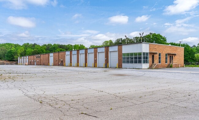
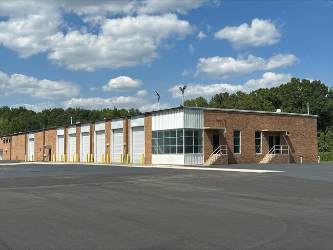
2300 Jonesboro Rd Se
Atlanta-Sandy Springs-Roswell, GA
Jim Morgan Card 2 Bldg
14-0027-LL-136-3
KA 01 TRANSUS PIGGY BACK 404-366-5788 JIM MORGAN CARD 2 BLDG SITS ON TOP OF THE TERMINAL
Truckterminal
Fulton
AE
Georgia
13121C0378F
27
2024
31.80 AC
2025
Airport/North Clayton
007002
Atlanta
63,536 SF
DEMOGRAPHICS near 2300 Jonesboro Rd Se
1 Mile
3 Mile
5 Mile
2024 Total Population
7,192
67,902
231,276
2029 Population
7,604
71,050
238,250
Pop Growth 2024-2029
+ 5.73%
+ 4.64%
+ 3.02%
Average Age
34
36
37
2024 Total Households
2,392
26,013
95,578
HH Growth 2024-2029
+ 5.85%
+ 4.81%
+ 3.29%
Median Household Inc
$33,883
$52,360
$59,432
Avg Household Size
2.80
2.40
2.20
2024 Avg HH Vehicles
1.00
1.00
1.00
Median Home Value
$172,846
$286,775
$297,478
Median Year Built
1968
1975
1975
Nearby Places
- Restaurants
- Banks
- Shops
- Fitness
- Groceries
PUBLIC TRANSPORTATION
COMMUTER RAIL
DRIVE
WALK
Distance
15 min
9.2 mi
AIRPORT
Hartsfield - Jackson Atlanta International
DRIVE
WALK
Distance
Hartsfield - Jackson Atlanta International
13 min
6.9 mi
Nearby Properties
Address
Land Use
TOTAL SIZE
Lot Size
Zoning
Address
Land Use
TOTAL SIZE
Lot Size
Zoning
432,056 SF
17.87 AC
C1
Address
Land Use
TOTAL SIZE
Lot Size
Zoning
595,658 SF
4.09 AC
I1
Address
Land Use
TOTAL SIZE
Lot Size
Zoning
94.93 AC
R5
Address
Land Use
TOTAL SIZE
Lot Size
Zoning
54 AC
I2
Address
Land Use
TOTAL SIZE
Lot Size
Zoning
436,143 SF
2.90 AC
I1
Address
Land Use
TOTAL SIZE
Lot Size
Zoning
330,125 SF
7.16 AC
I1
Address
Land Use
TOTAL SIZE
Lot Size
Zoning
828,718 SF
2.60 AC
I1
Address
Land Use
TOTAL SIZE
Lot Size
Zoning
1,128,762 SF
10.39 AC
I2
Address
Land Use
TOTAL SIZE
Lot Size
Zoning
318,300 SF
4.60 AC
I1
Address
Land Use
TOTAL SIZE
Lot Size
Zoning
381,983 SF
52.54 AC
M
Address
Land Use
TOTAL SIZE
Lot Size
Zoning
313,734 SF
22.60 AC
R5
Address
Land Use
TOTAL SIZE
Lot Size
Zoning
381,923 SF
19.72 AC
M
Address
Land Use
TOTAL SIZE
Lot Size
Zoning
7.65 AC
R5
Address
Land Use
TOTAL SIZE
Lot Size
Zoning
164,664 SF
4.93 AC
I1
Address
Land Use
TOTAL SIZE
Lot Size
Zoning
1,352,250 SF
3.18 AC
C2
Address
Land Use
TOTAL SIZE
Lot Size
Zoning
375,336 SF
22.76 AC
M
Address
Land Use
TOTAL SIZE
Lot Size
Zoning
1,680 SF
2.45 AC
I2
Address
Land Use
TOTAL SIZE
Lot Size
Zoning
59,807 SF
43.70 AC
X
Address
Land Use
TOTAL SIZE
Lot Size
Zoning
150,899 SF
21.89 AC
X
Address
Land Use
TOTAL SIZE
Lot Size
Zoning
12 AC
R4
Address
Land Use
TOTAL SIZE
Lot Size
Zoning
814,461 SF
29.12 AC
RG2
Address
Land Use
TOTAL SIZE
Lot Size
Zoning
402,544 SF
20.43 AC
I1
Address
Land Use
TOTAL SIZE
Lot Size
Zoning
54.47 AC
OI
Address
Land Use
TOTAL SIZE
Lot Size
Zoning
118,310 SF
10.90 AC
RM85
Address
Land Use
TOTAL SIZE
Lot Size
Zoning
44,365 SF
17.77 AC
M
Address
Land Use
TOTAL SIZE
Lot Size
Zoning
87,382 SF
83.24 AC
I1C
Address
Land Use
TOTAL SIZE
Lot Size
Zoning
39.06 AC
OI
Address
Land Use
TOTAL SIZE
Lot Size
Zoning
86,071 SF
18 AC
M
Address
Land Use
TOTAL SIZE
Lot Size
Zoning
279,108 SF
6.06 AC
C2
Address
Land Use
TOTAL SIZE
Lot Size
Zoning
403,328 SF
31.30 AC
I1
The World's #1 Commercial Real Estate Marketplace
Connect with us
© 2025 CoStar Group
The information above has been obtained from sources believed reliable. While we do not doubt its accuracy we have not verified it and make no guarantee, warranty or representation about it. It is your responsibility to independently confirm its accuracy and completeness. Any projections, opinions, assumptions, or estimates used are for example only and do not represent the current or future performance of the property. The value of this transaction to you depends on tax and other factors which should be evaluated by your tax, financial, and legal advisors. You and your advisors should conduct a careful, independent investigation of the property to determine to your satisfaction the suitability of the property for your needs.