Property Record
2300 Lancaster Hwy, Monroe, NC 28112
NEARBY LISTINGS FOR SALE OR LEASE
-
-
View all Monroe listings for sale on LoopNet.com
Property Detail
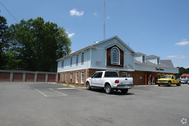
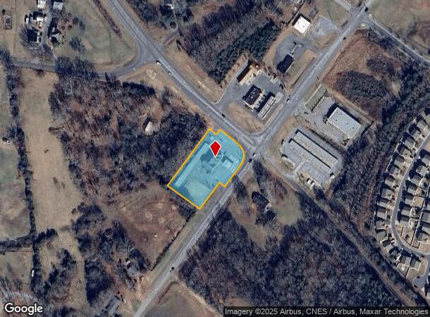
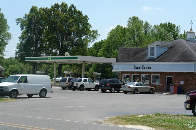
2300 Lancaster Hwy
09-327-018-A
PERRY 2302 LANCASTER HWY
Conveniencestore
Union
X
North Carolina
3710542400J
1.72 AC
2025
Union County
2025
Charlotte
020501
Charlotte-Concord-Gastonia, NC-SC
5,666 SF
DEMOGRAPHICS near 2300 Lancaster Hwy
1 Mile
3 Mile
5 Mile
2024 Total Population
2,129
19,613
45,024
2029 Population
2,379
21,976
50,677
Pop Growth 2024-2029
+ 11.74%
+ 12.05%
+ 12.56%
Average Age
40
39
39
2024 Total Households
762
7,000
16,010
HH Growth 2024-2029
+ 12.07%
+ 12.23%
+ 12.73%
Median Household Inc
$74,280
$58,125
$65,992
Avg Household Size
2.70
2.70
2.70
2024 Avg HH Vehicles
2.00
2.00
2.00
Median Home Value
$212,661
$224,093
$249,963
Median Year Built
1991
1985
1989
Nearby Places
Map Layers
Map Styles
 Street
 Aerial
- Restaurants
- Banks
- Shops
- Fitness
- Groceries
PUBLIC TRANSPORTATION
AIRPORT
Charlotte/Douglas International
DRIVE
WALK
Distance
Charlotte/Douglas International
51 min
34.2 mi
Freight Ports
North Charleston Terminal
DRIVE
WALK
Distance
North Charleston Terminal
221 min
185.9 mi
Nearby Properties
Address
Land Use
TOTAL SIZE
Lot Size
Zoning
Address
Land Use
TOTAL SIZE
Lot Size
Zoning
99,235 SF
1.92 AC
CBD MONROE
Address
Land Use
TOTAL SIZE
Lot Size
Zoning
57,664 SF
45.15 AC
R-20 MONRO
Address
Land Use
TOTAL SIZE
Lot Size
Zoning
71,831 SF
67.94 AC
CD MONROE
Address
Land Use
TOTAL SIZE
Lot Size
Zoning
79,493 SF
18.97 AC
CD MONROE
Address
Land Use
TOTAL SIZE
Lot Size
Zoning
7,104 SF
11.99 AC
R-MF MONRO
Address
Land Use
TOTAL SIZE
Lot Size
Zoning
5.89 AC
G-I MONROE
Address
Land Use
TOTAL SIZE
Lot Size
Zoning
4,608 SF
5.08 AC
OT MONROE
Address
Land Use
TOTAL SIZE
Lot Size
Zoning
101,035 SF
26.11 AC
G-I MONROE
Address
Land Use
TOTAL SIZE
Lot Size
Zoning
9,072 SF
15.23 AC
R-MF MONRO
Address
Land Use
TOTAL SIZE
Lot Size
Zoning
3,276 SF
6.20 AC
R-MF MONRO
Address
Land Use
TOTAL SIZE
Lot Size
Zoning
41,820 SF
6.23 AC
G-I MONROE
Address
Land Use
TOTAL SIZE
Lot Size
Zoning
65,122 SF
5.26 AC
R-10 MONRO
Address
Land Use
TOTAL SIZE
Lot Size
Zoning
17 AC
R-20 MONRO
Address
Land Use
TOTAL SIZE
Lot Size
Zoning
33,699 SF
2.55 AC
OT MONROE
Address
Land Use
TOTAL SIZE
Lot Size
Zoning
18,200 SF
0.76 AC
CBD MONROE
Address
Land Use
TOTAL SIZE
Lot Size
Zoning
30.44 AC
R-20 UNION
Address
Land Use
TOTAL SIZE
Lot Size
Zoning
20,700 SF
4.76 AC
CBD MONROE
Address
Land Use
TOTAL SIZE
Lot Size
Zoning
4.42 AC
GB MONROE
Address
Land Use
TOTAL SIZE
Lot Size
Zoning
97,344 SF
31.11 AC
R-10 MONRO
Address
Land Use
TOTAL SIZE
Lot Size
Zoning
21,576 SF
1.37 AC
GB MONROE
Address
Land Use
TOTAL SIZE
Lot Size
Zoning
155,110 SF
21.75 AC
G-I MONROE
Address
Land Use
TOTAL SIZE
Lot Size
Zoning
36,821 SF
1.75 AC
OT MONROE
Address
Land Use
TOTAL SIZE
Lot Size
Zoning
2,440 SF
7.30 AC
R-MF MONRO
Address
Land Use
TOTAL SIZE
Lot Size
Zoning
8,064 SF
3.52 AC
R-MF MONRO
Address
Land Use
TOTAL SIZE
Lot Size
Zoning
35,008 SF
1.37 AC
OT MONROE
Address
Land Use
TOTAL SIZE
Lot Size
Zoning
7,612 SF
0.34 AC
CBD MONROE
Address
Land Use
TOTAL SIZE
Lot Size
Zoning
5,102 SF
8.18 AC
R-10 MONRO
Address
Land Use
TOTAL SIZE
Lot Size
Zoning
3,832 SF
4.74 AC
R-MF MONRO
Address
Land Use
TOTAL SIZE
Lot Size
Zoning
4,200 SF
2.89 AC
R-MF MONRO
Address
Land Use
TOTAL SIZE
Lot Size
Zoning
8,308 SF
2.92 AC
R-MF MONRO
The World's #1 Commercial Real Estate Marketplace
Connect with us
© 2026 CoStar Group
The information above has been obtained from sources believed reliable. While we do not doubt its accuracy we have not verified it and make no guarantee, warranty or representation about it. It is your responsibility to independently confirm its accuracy and completeness. Any projections, opinions, assumptions, or estimates used are for example only and do not represent the current or future performance of the property. The value of this transaction to you depends on tax and other factors which should be evaluated by your tax, financial, and legal advisors. You and your advisors should conduct a careful, independent investigation of the property to determine to your satisfaction the suitability of the property for your needs.