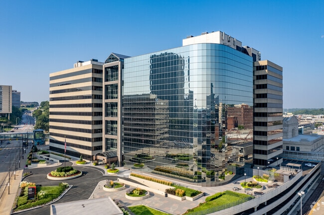
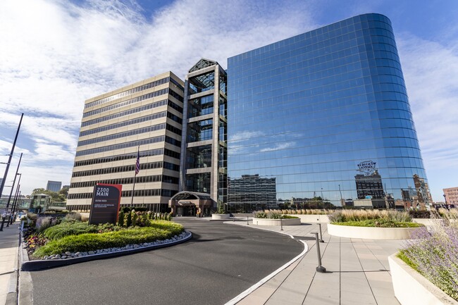
Property Record
2300 Main St, Kansas City, MO 64108
Current Lease Availabilities
NEARBY LISTINGS FOR SALE OR LEASE
Property Detail
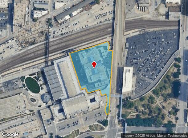
2300 Main St
Kansas City, MO-KS
Two Pershing Square
29-520-46-09-00-0-00-000
TWO PERSHING SQUARE---LOT 1 & PT SEC 8-49-33 & PT LOT 1 AMTR AK STATION DAF: BEG MOST ELY NE COR LOT 1 TWO PERSHING SQUAR E TH N 1.31 TH W 39.18 TH N 56.38 TH N 18 DEG W 32.71 TO
Officebuilding
Jackson
X
Missouri
29095C0254G
1
2024
3.74 AC
2025
Crown Center
015800
Kansas City
250,410 SF
DEMOGRAPHICS near 2300 Main St
1 Mile
3 Mile
5 Mile
2024 Total Population
12,998
116,907
262,545
2029 Population
13,404
119,399
265,929
Pop Growth 2024-2029
+ 3.12%
+ 2.13%
+ 1.29%
Average Age
37
36
37
2024 Total Households
7,125
56,383
113,611
HH Growth 2024-2029
+ 3.27%
+ 2.24%
+ 1.46%
Median Household Inc
$82,469
$52,838
$50,709
Avg Household Size
1.70
1.90
2.20
2024 Avg HH Vehicles
1.00
1.00
1.00
Median Home Value
$317,252
$192,446
$165,609
Median Year Built
1974
1955
1951
Nearby Places
Map Layers
Map Styles
 Street
 Aerial
- Restaurants
- Banks
- Shops
- Fitness
- Groceries
PUBLIC TRANSPORTATION
TRANSIT/SUBWAY
Union Station On Main At Pershing Sb (KC Streetcar - Kansas City Area Transportation Authority)
DRIVE
WALK
Distance
Union Station On Main At Pershing Sb (KC Streetcar - Kansas City Area Transportation Authority)
0 min
4 min
0.1 mi
Union Station On Main At Pershing Sb (KC Streetcar - KCATA)
DRIVE
WALK
Distance
Union Station On Main At Pershing Sb (KC Streetcar - KCATA)
0 min
4 min
0.1 mi
Crossroads On Main At 19Th St Sb (KC Streetcar - KCATA)
DRIVE
WALK
Distance
Crossroads On Main At 19Th St Sb (KC Streetcar - KCATA)
1 min
8 min
0.3 mi
Kauffman Center On Main At 16Th St Sb (KC Streetcar - KCATA)
DRIVE
WALK
Distance
Kauffman Center On Main At 16Th St Sb (KC Streetcar - KCATA)
1 min
13 min
0.6 mi
Power & Light On Main At 14Th St Sb (KC Streetcar - KCATA)
DRIVE
WALK
Distance
Power & Light On Main At 14Th St Sb (KC Streetcar - KCATA)
2 min
17 min
0.8 mi
COMMUTER RAIL
Kansas City (Lincoln Service Missouri River Runner - Amtrak, Missouri River Runner - Amtrak, Southwest Chief - Amtrak)
DRIVE
WALK
Distance
Kansas City (Lincoln Service Missouri River Runner - Amtrak, Missouri River Runner - Amtrak, Southwest Chief - Amtrak)
2 min
5 min
0.3 mi
Independence Amtrak Station (Lincoln Service Missouri River Runner - Amtrak, Missouri River Runner - Amtrak)
DRIVE
WALK
Distance
Independence Amtrak Station (Lincoln Service Missouri River Runner - Amtrak, Missouri River Runner - Amtrak)
18 min
9.3 mi
AIRPORT
Kansas City International
DRIVE
WALK
Distance
Kansas City International
29 min
20.2 mi
Freight Ports
Tulsa Port Of Catoosa
DRIVE
WALK
Distance
Tulsa Port Of Catoosa
267 min
238.0 mi
Nearby Properties
Address
Land Use
TOTAL SIZE
Lot Size
Zoning
Address
Land Use
TOTAL SIZE
Lot Size
Zoning
761,113 SF
17.78 AC
KC3
Address
Land Use
TOTAL SIZE
Lot Size
Zoning
91,485 SF
10.11 AC
Address
Land Use
TOTAL SIZE
Lot Size
Zoning
208,800 SF
5.57 AC
KRP5
Address
Land Use
TOTAL SIZE
Lot Size
Zoning
172,810 SF
Address
Land Use
TOTAL SIZE
Lot Size
Zoning
191,956 SF
10.45 AC
KR1B
Address
Land Use
TOTAL SIZE
Lot Size
Zoning
568,235 SF
9.59 AC
Address
Land Use
TOTAL SIZE
Lot Size
Zoning
488,351 SF
8.34 AC
Address
Land Use
TOTAL SIZE
Lot Size
Zoning
132,304 SF
3.72 AC
KCD
Address
Land Use
TOTAL SIZE
Lot Size
Zoning
1,825,083 SF
25.77 AC
Address
Land Use
TOTAL SIZE
Lot Size
Zoning
63,748 SF
3.92 AC
Address
Land Use
TOTAL SIZE
Lot Size
Zoning
404,524 SF
5.51 AC
Address
Land Use
TOTAL SIZE
Lot Size
Zoning
711,196 SF
15.58 AC
Address
Land Use
TOTAL SIZE
Lot Size
Zoning
105,247 SF
0.72 AC
Address
Land Use
TOTAL SIZE
Lot Size
Zoning
277,042 SF
0.40 AC
Address
Land Use
TOTAL SIZE
Lot Size
Zoning
257,647 SF
3.63 AC
Address
Land Use
TOTAL SIZE
Lot Size
Zoning
277,267 SF
4.18 AC
KCD
Address
Land Use
TOTAL SIZE
Lot Size
Zoning
124,492 SF
4.24 AC
Address
Land Use
TOTAL SIZE
Lot Size
Zoning
626,244 SF
16.41 AC
Address
Land Use
TOTAL SIZE
Lot Size
Zoning
44,491 SF
1.96 AC
C3A2
Address
Land Use
TOTAL SIZE
Lot Size
Zoning
81,578 SF
1.63 AC
Address
Land Use
TOTAL SIZE
Lot Size
Zoning
115,627 SF
1.56 AC
Address
Land Use
TOTAL SIZE
Lot Size
Zoning
261,570 SF
1.82 AC
Address
Land Use
TOTAL SIZE
Lot Size
Zoning
162,989 SF
3.92 AC
KC0
Address
Land Use
TOTAL SIZE
Lot Size
Zoning
157,488 SF
1.60 AC
Address
Land Use
TOTAL SIZE
Lot Size
Zoning
87,294 SF
0.70 AC
Address
Land Use
TOTAL SIZE
Lot Size
Zoning
803,812 SF
5.85 AC
Address
Land Use
TOTAL SIZE
Lot Size
Zoning
129,265 SF
1.17 AC
Address
Land Use
TOTAL SIZE
Lot Size
Zoning
384,543 SF
5.40 AC
Address
Land Use
TOTAL SIZE
Lot Size
Zoning
614,978 SF
31.56 AC
Address
Land Use
TOTAL SIZE
Lot Size
Zoning
274,622 SF
1.35 AC
The World's #1 Commercial Real Estate Marketplace
Connect with us
© 2025 CoStar Group
The information above has been obtained from sources believed reliable. While we do not doubt its accuracy we have not verified it and make no guarantee, warranty or representation about it. It is your responsibility to independently confirm its accuracy and completeness. Any projections, opinions, assumptions, or estimates used are for example only and do not represent the current or future performance of the property. The value of this transaction to you depends on tax and other factors which should be evaluated by your tax, financial, and legal advisors. You and your advisors should conduct a careful, independent investigation of the property to determine to your satisfaction the suitability of the property for your needs.