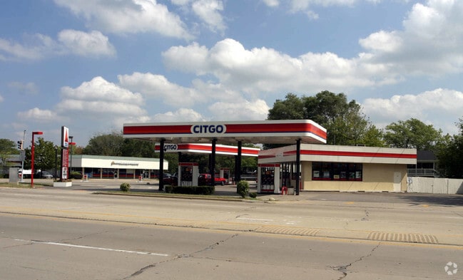
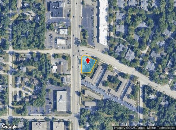
Property Record
2300 Plum Grove Rd, Rolling Meadows, IL 60008
NEARBY LISTINGS FOR SALE OR LEASE
Property Detail
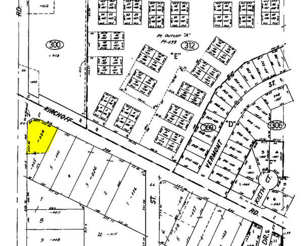
2300 Plum Grove Rd
Chicago-Naperville-Elgin, IL-IN-WI
Mcintosh & Cos Palatine Estates Unit3
02-26-301-024-0000
A.T.(MCINTOSH) & COS (PALATINE) ESTATES (UNIT3) SUB O F PTS OF SECS 26 & SEC 27-42-10
Servicestation
Cook
X
Illinois
17031C0183J
6
2023
0.49 AC
2024
Schaumburg Area
804109
Chicago
1,729 SF
DEMOGRAPHICS near 2300 Plum Grove Rd
1 Mile
3 Mile
5 Mile
2024 Total Population
12,300
91,306
266,720
2029 Population
11,925
88,535
258,808
Pop Growth 2024-2029
(3.05%)
(3.03%)
(2.97%)
Average Age
41
42
41
2024 Total Households
4,745
37,154
104,524
HH Growth 2024-2029
(3.39%)
(3.33%)
(3.27%)
Median Household Inc
$117,083
$98,680
$94,455
Avg Household Size
2.50
2.40
2.50
2024 Avg HH Vehicles
2.00
2.00
2.00
Median Home Value
$391,800
$333,416
$343,704
Median Year Built
1978
1973
1975
Nearby Places
Map Layers
Map Styles
 Street
 Aerial
- Restaurants
- Banks
- Shops
- Fitness
- Groceries
PUBLIC TRANSPORTATION
COMMUTER RAIL
Palatine Station (Union Pacific Northwest Line - Northeast Illinois Regional Commuter Railroad (Metra))
DRIVE
WALK
Distance
Palatine Station (Union Pacific Northwest Line - Northeast Illinois Regional Commuter Railroad (Metra))
5 min
2.4 mi
Arlington Park Station (Union Pacific Northwest Line - Northeast Illinois Regional Commuter Railroad (Metra))
DRIVE
WALK
Distance
Arlington Park Station (Union Pacific Northwest Line - Northeast Illinois Regional Commuter Railroad (Metra))
7 min
2.7 mi
AIRPORT
Chicago O'Hare International
DRIVE
WALK
Distance
Chicago O'Hare International
21 min
14.9 mi
Chicago Midway International
DRIVE
WALK
Distance
Chicago Midway International
44 min
31.0 mi
Nearby Properties
Address
Land Use
TOTAL SIZE
Lot Size
Zoning
Address
Land Use
TOTAL SIZE
Lot Size
Zoning
42.14 AC
Address
Land Use
TOTAL SIZE
Lot Size
Zoning
800,552 SF
38.86 AC
Address
Land Use
TOTAL SIZE
Lot Size
Zoning
Address
Land Use
TOTAL SIZE
Lot Size
Zoning
Address
Land Use
TOTAL SIZE
Lot Size
Zoning
300,000 SF
9.29 AC
Address
Land Use
TOTAL SIZE
Lot Size
Zoning
961,890 SF
42.21 AC
Address
Land Use
TOTAL SIZE
Lot Size
Zoning
875,776 SF
8.73 AC
Address
Land Use
TOTAL SIZE
Lot Size
Zoning
369,303 SF
29.96 AC
Address
Land Use
TOTAL SIZE
Lot Size
Zoning
Address
Land Use
TOTAL SIZE
Lot Size
Zoning
510,788 SF
39.93 AC
Address
Land Use
TOTAL SIZE
Lot Size
Zoning
303,671 SF
10.94 AC
Address
Land Use
TOTAL SIZE
Lot Size
Zoning
427,761 SF
30.41 AC
Address
Land Use
TOTAL SIZE
Lot Size
Zoning
388,080 SF
12.64 AC
Address
Land Use
TOTAL SIZE
Lot Size
Zoning
298,493 SF
9.76 AC
Address
Land Use
TOTAL SIZE
Lot Size
Zoning
14,099 SF
2.01 AC
Address
Land Use
TOTAL SIZE
Lot Size
Zoning
239,700 SF
Address
Land Use
TOTAL SIZE
Lot Size
Zoning
490,458 SF
13.52 AC
Address
Land Use
TOTAL SIZE
Lot Size
Zoning
544,744 SF
14.87 AC
Address
Land Use
TOTAL SIZE
Lot Size
Zoning
117,825 SF
4.49 AC
Address
Land Use
TOTAL SIZE
Lot Size
Zoning
375,417 SF
13.35 AC
Address
Land Use
TOTAL SIZE
Lot Size
Zoning
Address
Land Use
TOTAL SIZE
Lot Size
Zoning
29.21 AC
Address
Land Use
TOTAL SIZE
Lot Size
Zoning
303,701 SF
31.18 AC
Address
Land Use
TOTAL SIZE
Lot Size
Zoning
150,452 SF
15.26 AC
Address
Land Use
TOTAL SIZE
Lot Size
Zoning
212,192 SF
7.05 AC
Address
Land Use
TOTAL SIZE
Lot Size
Zoning
148,220 SF
Address
Land Use
TOTAL SIZE
Lot Size
Zoning
286,720 SF
9.77 AC
Address
Land Use
TOTAL SIZE
Lot Size
Zoning
45,259 SF
2.33 AC
Address
Land Use
TOTAL SIZE
Lot Size
Zoning
28,913 SF
6.63 AC
Address
Land Use
TOTAL SIZE
Lot Size
Zoning
93,333 SF
22.45 AC
The World's #1 Commercial Real Estate Marketplace
Connect with us
© 2025 CoStar Group
The information above has been obtained from sources believed reliable. While we do not doubt its accuracy we have not verified it and make no guarantee, warranty or representation about it. It is your responsibility to independently confirm its accuracy and completeness. Any projections, opinions, assumptions, or estimates used are for example only and do not represent the current or future performance of the property. The value of this transaction to you depends on tax and other factors which should be evaluated by your tax, financial, and legal advisors. You and your advisors should conduct a careful, independent investigation of the property to determine to your satisfaction the suitability of the property for your needs.