Property Record
2300 Radium Springs Rd, Albany, GA 31705
NEARBY LISTINGS FOR SALE OR LEASE
-
-
View all Albany listings for sale on LoopNet.com
Property Detail
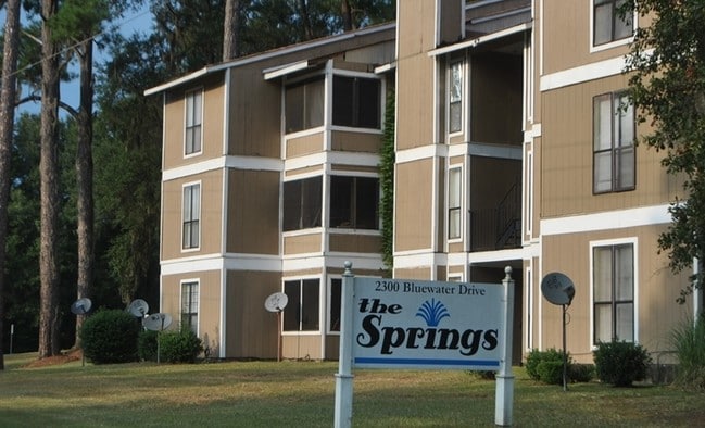
2300 Radium Springs Rd
00185-00002-11A
Radium Springs
Apartment
SPRINGS APTS
AE
Dougherty
13095C0117E
Georgia
2025
4.28 AC
2024
Albany/Southwest
011600
Other Market Areas
4,980 SF
Albany, GA
DEMOGRAPHICS near 2300 Radium Springs Rd
1 Mile
3 Mile
5 Mile
2024 Total Population
2,512
18,493
48,202
2029 Population
2,446
17,937
46,493
Pop Growth 2024-2029
(2.63%)
(3.01%)
(3.55%)
Average Age
35
37
38
2024 Total Households
782
7,162
19,395
HH Growth 2024-2029
(3.20%)
(3.17%)
(3.65%)
Median Household Inc
$37,999
$32,065
$32,433
Avg Household Size
2.40
2.30
2.30
2024 Avg HH Vehicles
1.00
1.00
1.00
Median Home Value
$79,698
$73,269
$72,559
Median Year Built
1967
1970
1969
Nearby Places
Map Layers
Map Styles
 Street
 Aerial
- Restaurants
- Banks
- Shops
- Fitness
- Groceries
PUBLIC TRANSPORTATION
AIRPORT
Southwest Georgia Regional
DRIVE
WALK
Distance
Southwest Georgia Regional
11 min
5.5 mi
Freight Ports
Port of Panama City
DRIVE
WALK
Distance
Port of Panama City
231 min
159.7 mi
SALE & LEASE HISTORY
LISTING DATE
SALE/LEASE

Sep 24, 2016
For Sale
Aug 23, 2017
For Sale
Nearby Properties
Address
Land Use
TOTAL SIZE
Lot Size
Zoning
Address
Land Use
TOTAL SIZE
Lot Size
Zoning
34,888 SF
164.47 AC
M2
Address
Land Use
TOTAL SIZE
Lot Size
Zoning
1,445,486 SF
108.05 AC
M1
Address
Land Use
TOTAL SIZE
Lot Size
Zoning
15.20 AC
C2
Address
Land Use
TOTAL SIZE
Lot Size
Zoning
2.53 AC
C2
Address
Land Use
TOTAL SIZE
Lot Size
Zoning
2,100 SF
9.92 AC
M1
Address
Land Use
TOTAL SIZE
Lot Size
Zoning
141,600 SF
45.43 AC
C1
Address
Land Use
TOTAL SIZE
Lot Size
Zoning
288,982 SF
39.52 AC
M1
Address
Land Use
TOTAL SIZE
Lot Size
Zoning
77,688 SF
2.93 AC
C3
Address
Land Use
TOTAL SIZE
Lot Size
Zoning
70,596 SF
2.38 AC
C2
Address
Land Use
TOTAL SIZE
Lot Size
Zoning
232,840 SF
49.88 AC
M1
Address
Land Use
TOTAL SIZE
Lot Size
Zoning
9,000 SF
184.88 AC
M2
Address
Land Use
TOTAL SIZE
Lot Size
Zoning
7.70 AC
ZZ
Address
Land Use
TOTAL SIZE
Lot Size
Zoning
9.37 AC
C3
Address
Land Use
TOTAL SIZE
Lot Size
Zoning
475,976 SF
51.30 AC
M1
Address
Land Use
TOTAL SIZE
Lot Size
Zoning
28,713 SF
9.96 AC
C3
Address
Land Use
TOTAL SIZE
Lot Size
Zoning
30,336 SF
19.19 AC
R6
Address
Land Use
TOTAL SIZE
Lot Size
Zoning
30,026 SF
34.47 AC
M1
Address
Land Use
TOTAL SIZE
Lot Size
Zoning
109,570 SF
18.45 AC
Address
Land Use
TOTAL SIZE
Lot Size
Zoning
1.54 AC
C3
Address
Land Use
TOTAL SIZE
Lot Size
Zoning
56,008 SF
24.76 AC
Address
Land Use
TOTAL SIZE
Lot Size
Zoning
34,746 SF
3.14 AC
C3
Address
Land Use
TOTAL SIZE
Lot Size
Zoning
47,844 SF
10.16 AC
C3
Address
Land Use
TOTAL SIZE
Lot Size
Zoning
61,412 SF
8.88 AC
M1
Address
Land Use
TOTAL SIZE
Lot Size
Zoning
22,141 SF
8.37 AC
AG
Address
Land Use
TOTAL SIZE
Lot Size
Zoning
133,840 SF
10 AC
M1
Address
Land Use
TOTAL SIZE
Lot Size
Zoning
60,110 SF
77.98 AC
M1
Address
Land Use
TOTAL SIZE
Lot Size
Zoning
10,120 SF
7.31 AC
C7
Address
Land Use
TOTAL SIZE
Lot Size
Zoning
88,425 SF
13.14 AC
M1
Address
Land Use
TOTAL SIZE
Lot Size
Zoning
10,825 SF
19.28 AC
M1
Address
Land Use
TOTAL SIZE
Lot Size
Zoning
5,584 SF
14.95 AC
FP
The World's #1 Commercial Real Estate Marketplace
Connect with us
© 2026 CoStar Group
The information above has been obtained from sources believed reliable. While we do not doubt its accuracy we have not verified it and make no guarantee, warranty or representation about it. It is your responsibility to independently confirm its accuracy and completeness. Any projections, opinions, assumptions, or estimates used are for example only and do not represent the current or future performance of the property. The value of this transaction to you depends on tax and other factors which should be evaluated by your tax, financial, and legal advisors. You and your advisors should conduct a careful, independent investigation of the property to determine to your satisfaction the suitability of the property for your needs.