No Photo
Property Record
2300 Shadow Valley Rd, High Point, NC 27265
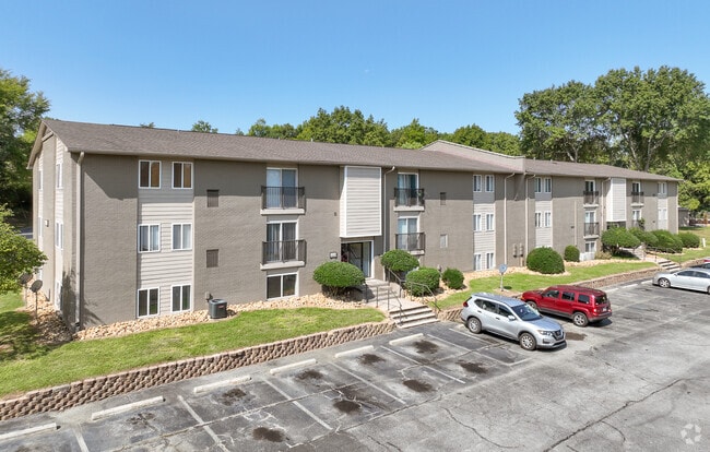
Property Detail
2300 Shadow Valley Rd
01-008-E-000-0002-A-0-0
P=17-114 L5 BK2556-1811&2588-1002
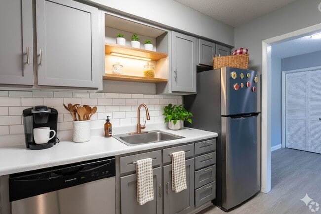
Gardenaptcourtapt5plusunits
DAVIDSON
RM16
North Carolina
B and X Area of moderate flood hazard, usually the area between the limits of the 100-year and 500-year floods.
5.77 AC
2025
Davidson
2025
Greensboro/Winston-Salem
060101
Winston-Salem, NC
28,366 SF
NEARBY LISTINGS FOR SALE OR LEASE
DEMOGRAPHICS near 2300 Shadow Valley Rd
1 mile
3 mile
5 mile
2025 Total Population
5,044
44,256
100,481
2030 Population
5,180
45,818
104,296
Pop Growth 2025-2030
+ 2.70%
+ 3.53%
+ 3.80%
Average Age
39
40
40
2025 Total Households
2,218
17,137
38,893
HH Growth 2025-2030
+ 2.80%
+ 3.83%
+ 4.04%
Median Household Inc
$80,661
$61,948
$59,438
Avg Household Size
2.30
2.30
2.40
2025 Avg HH Vehicles
2.00
2.00
2.00
Median Home Value
$254,889
$246,612
$242,508
Median Year Built
1984
1976
1979
Nearby Places
Map Layers
Map Styles
 Street
 Aerial
Transit
 Traffic
 Biking
Places
Listings with unknown addresses are not visible on the map
- Restaurants
- Banks
- Shops
- Fitness
- Groceries
PUBLIC TRANSPORTATION
COMMUTER RAIL
High Point Station (Piedmont - North Carolina by Train (NC Train))
Drive
Walk
Distance
High Point Station (Piedmont - North Carolina by Train (NC Train))
12 min
4.1 mi
AIRPORT
Piedmont Triad International
Drive
Walk
Distance
Piedmont Triad International
31 min
13.2 mi
Freight Ports
Port of Wilmington
Drive
Walk
Distance
Port of Wilmington
261 min
218.5 mi
SALE & LEASE HISTORY
LISTING DATE
SALE/LEASE

Apr 20, 2017
For Sale
Nearby Properties
Address
Land Use
TOTAL SIZE
Lot Size
Zoning
Address
Land Use
TOTAL SIZE
Lot Size
Zoning
264,860 SF
62.75 AC
PI
Address
Land Use
TOTAL SIZE
Lot Size
Zoning
418,654 SF
17.20 AC
PI
Address
Land Use
TOTAL SIZE
Lot Size
Zoning
236,597 SF
13.83 AC
CU-PI
Address
Land Use
TOTAL SIZE
Lot Size
Zoning
139,254 SF
0.01 AC
PI
Address
Land Use
TOTAL SIZE
Lot Size
Zoning
25,648 SF
40.16 AC
PDR
Address
Land Use
TOTAL SIZE
Lot Size
Zoning
706,686 SF
39.02 AC
R-5
Address
Land Use
TOTAL SIZE
Lot Size
Zoning
136,202 SF
30.02 AC
CZ-I
Address
Land Use
TOTAL SIZE
Lot Size
Zoning
285,094 SF
3.23 AC
CB
Address
Land Use
TOTAL SIZE
Lot Size
Zoning
100,121 SF
0.01 AC
PI
Address
Land Use
TOTAL SIZE
Lot Size
Zoning
215,222 SF
15.14 AC
RC
Address
Land Use
TOTAL SIZE
Lot Size
Zoning
185,320 SF
15.08 AC
PI
Address
Land Use
TOTAL SIZE
Lot Size
Zoning
170,183 SF
13.94 AC
RM-16
Address
Land Use
TOTAL SIZE
Lot Size
Zoning
166,196 SF
19.99 AC
RM-16
Address
Land Use
TOTAL SIZE
Lot Size
Zoning
164,027 SF
12.52 AC
RM-16
Address
Land Use
TOTAL SIZE
Lot Size
Zoning
90,060 SF
3.15 AC
CZ-I
Address
Land Use
TOTAL SIZE
Lot Size
Zoning
56,029 SF
9.36 AC
CU-GB
Address
Land Use
TOTAL SIZE
Lot Size
Zoning
87,488 SF
0.01 AC
PI
Address
Land Use
TOTAL SIZE
Lot Size
Zoning
87,485 SF
17.21 AC
R-3
Address
Land Use
TOTAL SIZE
Lot Size
Zoning
161,377 SF
16.36 AC
CU-SC
Address
Land Use
TOTAL SIZE
Lot Size
Zoning
200,288 SF
2.58 AC
CB
Address
Land Use
TOTAL SIZE
Lot Size
Zoning
4,500 SF
6.98 AC
MX-D
Address
Land Use
TOTAL SIZE
Lot Size
Zoning
94,632 SF
1.13 AC
MX-D
Address
Land Use
TOTAL SIZE
Lot Size
Zoning
244,197 SF
14.76 AC
RM-26
Address
Land Use
TOTAL SIZE
Lot Size
Zoning
133,710 SF
8.70 AC
RM-16
Address
Land Use
TOTAL SIZE
Lot Size
Zoning
145,571 SF
11.01 AC
RC
Address
Land Use
TOTAL SIZE
Lot Size
Zoning
105,676 SF
24.20 AC
R-5
Address
Land Use
TOTAL SIZE
Lot Size
Zoning
132,012 SF
12.99 AC
RM-16
Address
Land Use
TOTAL SIZE
Lot Size
Zoning
184,724 SF
15.71 AC
RM-16
Address
Land Use
TOTAL SIZE
Lot Size
Zoning
85,233 SF
4.56 AC
CU-PDM
Address
Land Use
TOTAL SIZE
Lot Size
Zoning
65,520 SF
3.88 AC
MS
The World's #1 Commercial Real Estate Marketplace
Connect with us
© 2026 CoStar Group
The information above has been obtained from sources believed reliable. While we do not doubt its accuracy we have not verified it and make no guarantee, warranty or representation about it. It is your responsibility to independently confirm its accuracy and completeness. Any projections, opinions, assumptions, or estimates used are for example only and do not represent the current or future performance of the property. The value of this transaction to you depends on tax and other factors which should be evaluated by your tax, financial, and legal advisors. You and your advisors should conduct a careful, independent investigation of the property to determine to your satisfaction the suitability of the property for your needs.