Property Record
2301 172Nd St, Lansing, IL 60438


Save to a Folder
{{folder.Name}}
{{folder.ListingIds.length}} Properties
{{folder.ListingIds.length}} Property
Create a New Folder
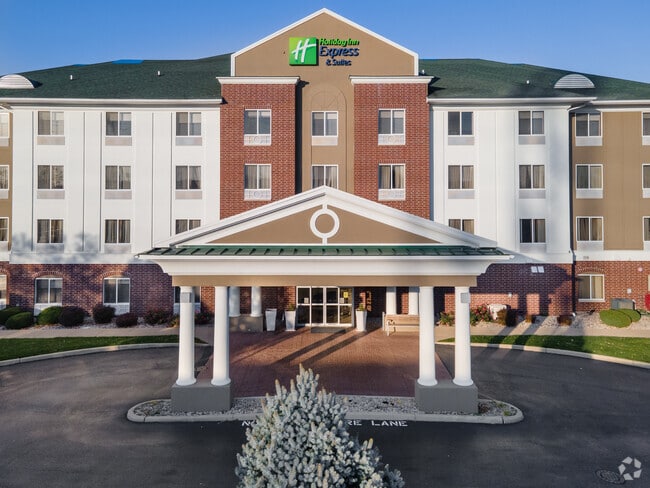
Property Detail
2301 172Nd St
29-25-205-035-0000
COOK
Motel
Illinois
B and X Area of moderate flood hazard, usually the area between the limits of the 100-year and 500-year floods.
1-8
2023
1.88 AC
2025
Chicago South/Midway Airport
827901
Chicago
47,103 SF
Chicago-Naperville-Elgin, IL-IN
NEARBY LISTINGS FOR SALE OR LEASE
DEMOGRAPHICS near 2301 172Nd St
1 mile
3 mile
5 mile
2025 Total Population
7,381
105,043
239,622
2030 Population
7,449
105,840
241,655
Pop Growth 2025-2030
+ 0.92%
+ 0.76%
+ 0.85%
Average Age
44
41
40
2025 Total Households
2,903
40,039
89,664
HH Growth 2025-2030
+ 0.76%
+ 0.52%
+ 0.66%
Median Household Inc
$61,596
$66,898
$64,068
Avg Household Size
2.40
2.50
2.60
2025 Avg HH Vehicles
2.00
2.00
2.00
Median Home Value
$215,474
$176,170
$175,491
Median Year Built
1973
1964
1962
Nearby Places
Map Layers
Map Styles
 Street
 Aerial
Layers
 Traffic
 Biking
Places
Listings with unknown addresses are not visible on the map
- Restaurants
- Banks
- Shops
- Fitness
- Groceries
PUBLIC TRANSPORTATION
COMMUTER RAIL
Hegewisch Station (South Shore Line - Northern Indiana Commuter Transportation District (South Shore Line))
Drive
Walk
Distance
Hegewisch Station (South Shore Line - Northern Indiana Commuter Transportation District (South Shore Line))
10 min
5.5 mi
Drive
Walk
Distance
12 min
6.1 mi
AIRPORT
Chicago Midway International
Drive
Walk
Distance
Chicago Midway International
36 min
23.4 mi
Chicago O'Hare International
Drive
Walk
Distance
Chicago O'Hare International
61 min
45.1 mi
Nearby Properties
Address
Land Use
TOTAL SIZE
Lot Size
Zoning
Address
Land Use
TOTAL SIZE
Lot Size
Zoning
24.56 AC
Address
Land Use
TOTAL SIZE
Lot Size
Zoning
Address
Land Use
TOTAL SIZE
Lot Size
Zoning
97,046 SF
3.36 AC
Address
Land Use
TOTAL SIZE
Lot Size
Zoning
135,617 SF
7.80 AC
Address
Land Use
TOTAL SIZE
Lot Size
Zoning
149,623 SF
4.93 AC
Address
Land Use
TOTAL SIZE
Lot Size
Zoning
5.01 AC
Address
Land Use
TOTAL SIZE
Lot Size
Zoning
122,628 SF
9.40 AC
Address
Land Use
TOTAL SIZE
Lot Size
Zoning
41,928 SF
3.71 AC
Address
Land Use
TOTAL SIZE
Lot Size
Zoning
102,264 SF
8.61 AC
R3
Address
Land Use
TOTAL SIZE
Lot Size
Zoning
119,082 SF
Address
Land Use
TOTAL SIZE
Lot Size
Zoning
48,134 SF
5.33 AC
Address
Land Use
TOTAL SIZE
Lot Size
Zoning
21,009 SF
1.82 AC
Address
Land Use
TOTAL SIZE
Lot Size
Zoning
30,895 SF
3 AC
R33
Address
Land Use
TOTAL SIZE
Lot Size
Zoning
51,204 SF
0.34 AC
Address
Land Use
TOTAL SIZE
Lot Size
Zoning
69,894 SF
7.60 AC
Address
Land Use
TOTAL SIZE
Lot Size
Zoning
21,009 SF
1.82 AC
Address
Land Use
TOTAL SIZE
Lot Size
Zoning
56,458 SF
2.17 AC
Address
Land Use
TOTAL SIZE
Lot Size
Zoning
450,777 SF
25.25 AC
Address
Land Use
TOTAL SIZE
Lot Size
Zoning
4,732 SF
2.25 AC
Address
Land Use
TOTAL SIZE
Lot Size
Zoning
22,356 SF
2.42 AC
Address
Land Use
TOTAL SIZE
Lot Size
Zoning
65,442 SF
8.63 AC
Address
Land Use
TOTAL SIZE
Lot Size
Zoning
60,864 SF
5.55 AC
Address
Land Use
TOTAL SIZE
Lot Size
Zoning
14,647 SF
0.88 AC
Address
Land Use
TOTAL SIZE
Lot Size
Zoning
3,911 SF
0.68 AC
Address
Land Use
TOTAL SIZE
Lot Size
Zoning
7.31 AC
Address
Land Use
TOTAL SIZE
Lot Size
Zoning
66,118 SF
11.02 AC
Address
Land Use
TOTAL SIZE
Lot Size
Zoning
454,999 SF
27.43 AC
Address
Land Use
TOTAL SIZE
Lot Size
Zoning
40,489 SF
6.43 AC
Address
Land Use
TOTAL SIZE
Lot Size
Zoning
Address
Land Use
TOTAL SIZE
Lot Size
Zoning
25,058 SF
0.19 AC
The World's #1 Commercial Real Estate Marketplace
Connect with us
© 2026 CoStar Group
The information above has been obtained from sources believed reliable. While we do not doubt its accuracy we have not verified it and make no guarantee, warranty or representation about it. It is your responsibility to independently confirm its accuracy and completeness. Any projections, opinions, assumptions, or estimates used are for example only and do not represent the current or future performance of the property. The value of this transaction to you depends on tax and other factors which should be evaluated by your tax, financial, and legal advisors. You and your advisors should conduct a careful, independent investigation of the property to determine to your satisfaction the suitability of the property for your needs.