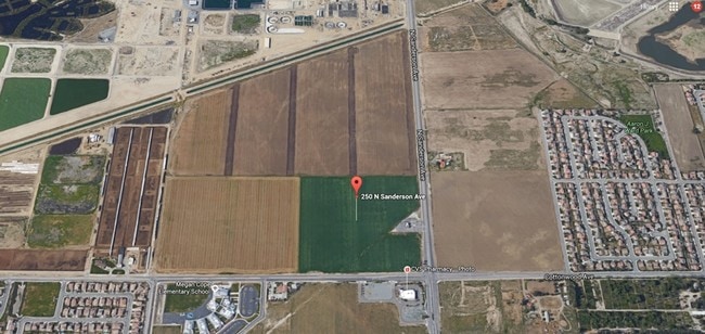
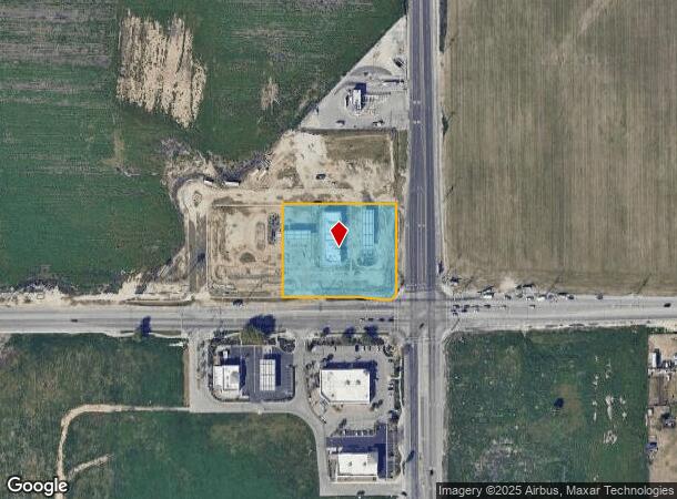
Property Record
250 N Sanderson Ave, San Jacinto, CA 92582

NEARBY LISTINGS FOR SALE OR LEASE
-
-
SWC S Sanderson Ave & Cottonwood Ave
San Jacinto, CA 92582
$688,000 - $2,222,000
0.79 - 1.13 AC Lot
Land
-
-
-
-
-
-
View all San Jacinto listings for sale on LoopNet.com
Property Detail
250 N Sanderson Ave
Riverside-San Bernardino-Ontario, CA
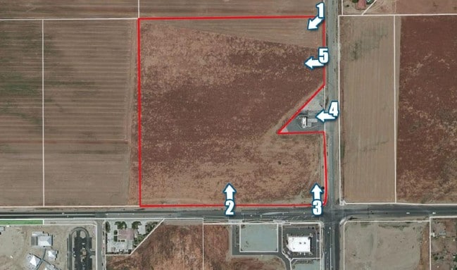
Parcel Map No 37299
432-130-016
ACRES 2.11000000 ACREAGEQUALCODE NT LOTTYPE P PARCEL 1 MAPPLATB 246 MAPPLATP 042 SUBDIVISIONNAME PM 37299
Servicestation
Riverside
X
California
06065C1470G
4
2024
2.11 AC
2025
Beaumont/Hemet
043517
Inland Empire (California)
8,680 SF
DEMOGRAPHICS near 250 N Sanderson Ave
1 Mile
3 Mile
5 Mile
2024 Total Population
7,540
59,948
143,278
2029 Population
7,924
63,448
151,503
Pop Growth 2024-2029
+ 5.09%
+ 5.84%
+ 5.74%
Average Age
33
37
38
2024 Total Households
1,738
18,700
47,209
HH Growth 2024-2029
+ 4.78%
+ 5.47%
+ 5.43%
Median Household Inc
$87,039
$53,641
$51,834
Avg Household Size
4.00
3.10
2.90
2024 Avg HH Vehicles
3.00
2.00
2.00
Median Home Value
$373,449
$310,813
$271,675
Median Year Built
2004
1990
1985
Nearby Places
Map Layers
Map Styles
 Street
 Aerial
- Restaurants
- Banks
- Shops
- Fitness
- Groceries
PUBLIC TRANSPORTATION
AIRPORT
Palm Springs International
DRIVE
WALK
Distance
Palm Springs International
50 min
42.4 mi
Freight Ports
Port of Long Beach
DRIVE
WALK
Distance
Port of Long Beach
110 min
85.2 mi
SALE & LEASE HISTORY
LISTING DATE
SALE/LEASE

Sep 24, 2016
For Sale
Nearby Properties
Address
Land Use
TOTAL SIZE
Lot Size
Zoning
Address
Land Use
TOTAL SIZE
Lot Size
Zoning
168,761 SF
20.67 AC
Address
Land Use
TOTAL SIZE
Lot Size
Zoning
94,476 SF
4.86 AC
R3
Address
Land Use
TOTAL SIZE
Lot Size
Zoning
50,160 SF
5.93 AC
R3
Address
Land Use
TOTAL SIZE
Lot Size
Zoning
53,140 SF
6.74 AC
C2
Address
Land Use
TOTAL SIZE
Lot Size
Zoning
40,880 SF
6 AC
R3
Address
Land Use
TOTAL SIZE
Lot Size
Zoning
66,482 SF
9.11 AC
A1
Address
Land Use
TOTAL SIZE
Lot Size
Zoning
167,396 SF
9.36 AC
Address
Land Use
TOTAL SIZE
Lot Size
Zoning
70,045 SF
4.23 AC
Address
Land Use
TOTAL SIZE
Lot Size
Zoning
42,064 SF
4.71 AC
C1
Address
Land Use
TOTAL SIZE
Lot Size
Zoning
72,308 SF
4.66 AC
M1
Address
Land Use
TOTAL SIZE
Lot Size
Zoning
58,941 SF
9.06 AC
M1
Address
Land Use
TOTAL SIZE
Lot Size
Zoning
58,941 SF
7.14 AC
Address
Land Use
TOTAL SIZE
Lot Size
Zoning
88,530 SF
18.41 AC
Address
Land Use
TOTAL SIZE
Lot Size
Zoning
1,396 SF
201.72 AC
A210
Address
Land Use
TOTAL SIZE
Lot Size
Zoning
104,713 SF
7.49 AC
Address
Land Use
TOTAL SIZE
Lot Size
Zoning
100,155 SF
8.28 AC
Address
Land Use
TOTAL SIZE
Lot Size
Zoning
60,472 SF
2.22 AC
A15
Address
Land Use
TOTAL SIZE
Lot Size
Zoning
10,800 SF
6.56 AC
Address
Land Use
TOTAL SIZE
Lot Size
Zoning
158.35 AC
A210
Address
Land Use
TOTAL SIZE
Lot Size
Zoning
67,146 SF
13.97 AC
Address
Land Use
TOTAL SIZE
Lot Size
Zoning
18,800 SF
2.79 AC
C1CP
Address
Land Use
TOTAL SIZE
Lot Size
Zoning
29,688 SF
1.46 AC
C2
Address
Land Use
TOTAL SIZE
Lot Size
Zoning
97,878 SF
2.62 AC
C1
Address
Land Use
TOTAL SIZE
Lot Size
Zoning
89,392 SF
1.11 AC
Address
Land Use
TOTAL SIZE
Lot Size
Zoning
17,936 SF
1.48 AC
C2
Address
Land Use
TOTAL SIZE
Lot Size
Zoning
38,026 SF
3.27 AC
R-1
Address
Land Use
TOTAL SIZE
Lot Size
Zoning
13,297 SF
1.40 AC
Address
Land Use
TOTAL SIZE
Lot Size
Zoning
14,908 SF
1.49 AC
Address
Land Use
TOTAL SIZE
Lot Size
Zoning
49,423 SF
3.31 AC
CP
The World's #1 Commercial Real Estate Marketplace
Connect with us
© 2025 CoStar Group
The information above has been obtained from sources believed reliable. While we do not doubt its accuracy we have not verified it and make no guarantee, warranty or representation about it. It is your responsibility to independently confirm its accuracy and completeness. Any projections, opinions, assumptions, or estimates used are for example only and do not represent the current or future performance of the property. The value of this transaction to you depends on tax and other factors which should be evaluated by your tax, financial, and legal advisors. You and your advisors should conduct a careful, independent investigation of the property to determine to your satisfaction the suitability of the property for your needs.