Property Record
2301 S 8Th St, Rogers, AR 72758


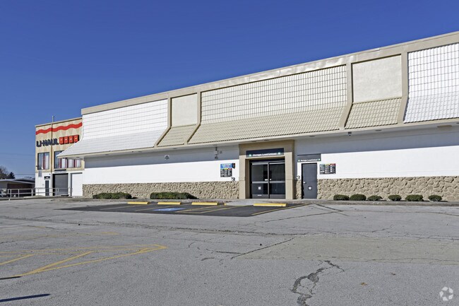

Property Detail
2301 S 8Th St
02-02018-000
ALL OF TRACT SS OF A LOT LINE ADJUSTMENT PLAT FILED FOR RECORD TFIE 28TH DAY OF AUGUST, 2000 UNDER PLAT DOCUMENT NUMBER P3-234 AND A PART OF THE SW 1/4 OF THE SE 1/4 AND A PART OF THE NW 1/4 OF THE SE 1/4, ALL IN SECTION 24, TOWNSHIP 19 NORH 1, RANGE
Storebuilding
Benton
B and X Area of moderate flood hazard, usually the area between the limits of the 100-year and 500-year floods.
Arkansas
2025
3.93 AC
2025
East Rogers
020206
Fayetteville/Springdale/Rogers
15,448 SF
Fayetteville-Springdale-Rogers, AR
NEARBY LISTINGS FOR SALE OR LEASE
DEMOGRAPHICS near 2301 S 8Th St
1 mile
3 mile
5 mile
2025 Total Population
10,079
51,185
102,720
2030 Population
11,107
56,617
113,440
Pop Growth 2025-2030
+ 10.20%
+ 10.61%
+ 10.44%
Average Age
34
36
37
2025 Total Households
3,179
18,192
37,103
HH Growth 2025-2030
+ 10.51%
+ 11.03%
+ 10.82%
Median Household Inc
$71,370
$73,780
$86,169
Avg Household Size
3.00
2.70
2.70
2025 Avg HH Vehicles
2.00
2.00
2.00
Median Home Value
$270,582
$286,955
$349,634
Median Year Built
1995
1994
1997
Nearby Places
Map Layers
Map Styles
 Street
 Aerial
Layers
 Traffic
 Biking
Places
Listings with unknown addresses are not visible on the map
- Restaurants
- Banks
- Shops
- Fitness
- Groceries
PUBLIC TRANSPORTATION
AIRPORT
Northwest Arkansas Ntl
Drive
Walk
Distance
Northwest Arkansas Ntl
29 min
16.7 mi
Nearby Properties
Address
Land Use
TOTAL SIZE
Lot Size
Zoning
Address
Land Use
TOTAL SIZE
Lot Size
Zoning
52,778 SF
1.04 AC
Address
Land Use
TOTAL SIZE
Lot Size
Zoning
441,673 SF
55.19 AC
Address
Land Use
TOTAL SIZE
Lot Size
Zoning
405,394 SF
10.97 AC
Address
Land Use
TOTAL SIZE
Lot Size
Zoning
412,893 SF
11.51 AC
Address
Land Use
TOTAL SIZE
Lot Size
Zoning
269,397 SF
27.07 AC
Address
Land Use
TOTAL SIZE
Lot Size
Zoning
305,450 SF
12.16 AC
Address
Land Use
TOTAL SIZE
Lot Size
Zoning
542,873 SF
16.52 AC
Address
Land Use
TOTAL SIZE
Lot Size
Zoning
365,674 SF
18.05 AC
Address
Land Use
TOTAL SIZE
Lot Size
Zoning
84,890 SF
5.89 AC
Address
Land Use
TOTAL SIZE
Lot Size
Zoning
166,973 SF
7.58 AC
Address
Land Use
TOTAL SIZE
Lot Size
Zoning
401,143 SF
31.17 AC
Address
Land Use
TOTAL SIZE
Lot Size
Zoning
210,971 SF
8.46 AC
Address
Land Use
TOTAL SIZE
Lot Size
Zoning
209,369 SF
21.60 AC
Address
Land Use
TOTAL SIZE
Lot Size
Zoning
20,878 SF
24.78 AC
Address
Land Use
TOTAL SIZE
Lot Size
Zoning
249,393 SF
10.70 AC
Address
Land Use
TOTAL SIZE
Lot Size
Zoning
203,254 SF
12.93 AC
Address
Land Use
TOTAL SIZE
Lot Size
Zoning
67,152 SF
6.28 AC
Address
Land Use
TOTAL SIZE
Lot Size
Zoning
102,477 SF
7.15 AC
Address
Land Use
TOTAL SIZE
Lot Size
Zoning
57,715 SF
7.60 AC
Address
Land Use
TOTAL SIZE
Lot Size
Zoning
75,063 SF
2.50 AC
Address
Land Use
TOTAL SIZE
Lot Size
Zoning
87,465 SF
5 AC
Address
Land Use
TOTAL SIZE
Lot Size
Zoning
205,851 SF
20.13 AC
Address
Land Use
TOTAL SIZE
Lot Size
Zoning
137,763 SF
10.51 AC
Address
Land Use
TOTAL SIZE
Lot Size
Zoning
29,670 SF
5.80 AC
Address
Land Use
TOTAL SIZE
Lot Size
Zoning
108,982 SF
11.89 AC
Address
Land Use
TOTAL SIZE
Lot Size
Zoning
53,503 SF
6.88 AC
Address
Land Use
TOTAL SIZE
Lot Size
Zoning
1,400 SF
49.77 AC
Address
Land Use
TOTAL SIZE
Lot Size
Zoning
62,671 SF
4.07 AC
Address
Land Use
TOTAL SIZE
Lot Size
Zoning
39,793 SF
4.94 AC
Address
Land Use
TOTAL SIZE
Lot Size
Zoning
25,683 SF
11.71 AC
The World's #1 Commercial Real Estate Marketplace
Connect with us
© 2026 CoStar Group
The information above has been obtained from sources believed reliable. While we do not doubt its accuracy we have not verified it and make no guarantee, warranty or representation about it. It is your responsibility to independently confirm its accuracy and completeness. Any projections, opinions, assumptions, or estimates used are for example only and do not represent the current or future performance of the property. The value of this transaction to you depends on tax and other factors which should be evaluated by your tax, financial, and legal advisors. You and your advisors should conduct a careful, independent investigation of the property to determine to your satisfaction the suitability of the property for your needs.