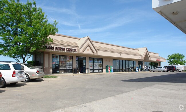
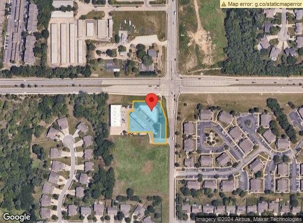
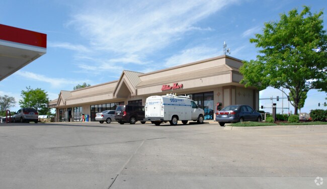
Property Record
2301 Wakarusa Dr, Lawrence, KS 66047
NEARBY LISTINGS FOR SALE OR LEASE
Property Detail
2301 Wakarusa Dr
Lawrence, KS
Subdivision 1857
023-112-09-0-00-00-006.02-0
SP 6-15-05 FROM U19007A STONEY POINT LT 1 BEG NE COR FOR POB SE 99.8 S 158.1 W 100 NNW 34 NW 39.7 W144.8 N 132.2 E 32.3 N
Conveniencestore
Douglas
X
Kansas
20045C0158D
1
2025
1.20 AC
2025
Lawrence
000801
Kansas City
6,771 SF
DEMOGRAPHICS near 2301 Wakarusa Dr
1 mile
3 mile
5 mile
2024 Total Population
6,186
50,626
92,749
2029 Population
6,313
51,564
94,613
Pop Growth 2024-2029
+ 2.05%
+ 1.85%
+ 2.01%
Average Age
38
36
36
2024 Total Households
2,743
21,358
39,046
HH Growth 2024-2029
+ 2.11%
+ 2.06%
+ 2.21%
Median Household Inc
$50,121
$56,402
$54,929
Avg Household Size
2.20
2.20
2.20
2024 Avg HH Vehicles
2.00
2.00
2.00
Median Home Value
$309,454
$281,284
$252,497
Median Year Built
1997
1993
1988
Nearby Places
Map Layers
Map Styles
 Street
 Aerial
Transit
 Traffic
 Biking
Places
Listings with unknown addresses are not visible on the map
- Restaurants
- Banks
- Shops
- Fitness
- Groceries
PUBLIC TRANSPORTATION
COMMUTER RAIL
Lawrence Amtrak Station (Southwest Chief - Amtrak)
Drive
Walk
Distance
Lawrence Amtrak Station (Southwest Chief - Amtrak)
11 min
6.4 mi
Freight Ports
Tulsa Port Of Catoosa
Drive
Walk
Distance
Tulsa Port Of Catoosa
253 min
212.3 mi
Nearby Properties
Address
Land Use
TOTAL SIZE
Lot Size
Zoning
Address
Land Use
TOTAL SIZE
Lot Size
Zoning
243,311 SF
20.07 AC
AG
Address
Land Use
TOTAL SIZE
Lot Size
Zoning
190,168 SF
55.04 AC
C2
Address
Land Use
TOTAL SIZE
Lot Size
Zoning
336,701 SF
5.20 AC
RD
Address
Land Use
TOTAL SIZE
Lot Size
Zoning
143,279 SF
36.20 AC
RS1
Address
Land Use
TOTAL SIZE
Lot Size
Zoning
181,346 SF
21.40 AC
497
Address
Land Use
TOTAL SIZE
Lot Size
Zoning
92,295 SF
10.40 AC
RS1
Address
Land Use
TOTAL SIZE
Lot Size
Zoning
11,992 SF
118.15 AC
RS1
Address
Land Use
TOTAL SIZE
Lot Size
Zoning
104,785 SF
105.60 AC
RS1
Address
Land Use
TOTAL SIZE
Lot Size
Zoning
1,034 SF
254.80 AC
AG
Address
Land Use
TOTAL SIZE
Lot Size
Zoning
56,172 SF
14.05 AC
AG
Address
Land Use
TOTAL SIZE
Lot Size
Zoning
92,819 SF
3.10 AC
RO2
Address
Land Use
TOTAL SIZE
Lot Size
Zoning
55,556 SF
24.90 AC
RM1
Address
Land Use
TOTAL SIZE
Lot Size
Zoning
52,000 SF
36 AC
RS1
Address
Land Use
TOTAL SIZE
Lot Size
Zoning
19,985 SF
103.37 AC
RS1
Address
Land Use
TOTAL SIZE
Lot Size
Zoning
55,275 SF
12.30 AC
AG
Address
Land Use
TOTAL SIZE
Lot Size
Zoning
51,366 SF
15 AC
RS2
Address
Land Use
TOTAL SIZE
Lot Size
Zoning
22,774 SF
3.49 AC
RD
Address
Land Use
TOTAL SIZE
Lot Size
Zoning
40,349 SF
5.02 AC
C2
Address
Land Use
TOTAL SIZE
Lot Size
Zoning
24,083 SF
3.60 AC
Address
Land Use
TOTAL SIZE
Lot Size
Zoning
7,050 SF
8.05 AC
RM1
Address
Land Use
TOTAL SIZE
Lot Size
Zoning
7,446 SF
4 AC
M1
Address
Land Use
TOTAL SIZE
Lot Size
Zoning
45,600 SF
5.70 AC
RS1
Address
Land Use
TOTAL SIZE
Lot Size
Zoning
21,147 SF
0.49 AC
Address
Land Use
TOTAL SIZE
Lot Size
Zoning
17,460 SF
3.90 AC
Address
Land Use
TOTAL SIZE
Lot Size
Zoning
20,591 SF
9.70 AC
Address
Land Use
TOTAL SIZE
Lot Size
Zoning
53,712 SF
7.74 AC
RS2
Address
Land Use
TOTAL SIZE
Lot Size
Zoning
96,860 SF
17.42 AC
C5
Address
Land Use
TOTAL SIZE
Lot Size
Zoning
15,228 SF
2.43 AC
RS2
Address
Land Use
TOTAL SIZE
Lot Size
Zoning
12,069 SF
11.60 AC
RS1
Address
Land Use
TOTAL SIZE
Lot Size
Zoning
47,666 SF
The World's #1 Commercial Real Estate Marketplace
Connect with us
© 2026 CoStar Group
The information above has been obtained from sources believed reliable. While we do not doubt its accuracy we have not verified it and make no guarantee, warranty or representation about it. It is your responsibility to independently confirm its accuracy and completeness. Any projections, opinions, assumptions, or estimates used are for example only and do not represent the current or future performance of the property. The value of this transaction to you depends on tax and other factors which should be evaluated by your tax, financial, and legal advisors. You and your advisors should conduct a careful, independent investigation of the property to determine to your satisfaction the suitability of the property for your needs.