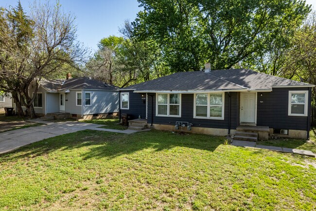
Property Record
2341 S Belmont St, Wichita, KS 67218

NEARBY LISTINGS FOR SALE OR LEASE
-
-
View all Wichita listings for sale on LoopNet.com
Property Detail
2341 S Belmont St
Wichita, KS
Elm Heights Add
127-35-0-43-07-003.00
Sedgwick
Duplex
Kansas
X
0.21 AC
20173C0368G
Southeast Wichita
3,237 SF
Wichita
DEMOGRAPHICS near 2341 S Belmont St
1 Mile
3 Mile
5 Mile
2024 Total Population
12,558
90,486
207,334
2029 Population
13,013
93,299
213,363
Pop Growth 2024-2029
+ 3.62%
+ 3.11%
+ 2.91%
Average Age
36
37
37
2024 Total Households
4,852
36,983
83,909
HH Growth 2024-2029
+ 3.57%
+ 3.04%
+ 2.93%
Median Household Inc
$41,068
$44,292
$45,989
Avg Household Size
2.40
2.30
2.30
2024 Avg HH Vehicles
2.00
2.00
2.00
Median Home Value
$89,196
$97,989
$112,612
Median Year Built
1956
1957
1961
Nearby Places
Map Layers
Map Styles
 Street
 Aerial
- Restaurants
- Banks
- Shops
- Fitness
- Groceries
PUBLIC TRANSPORTATION
AIRPORT
Wichita Dwight D Eisenhower Ntl
DRIVE
WALK
Distance
Wichita Dwight D Eisenhower Ntl
18 min
11.0 mi
Freight Ports
Tulsa Port Of Catoosa
DRIVE
WALK
Distance
Tulsa Port Of Catoosa
204 min
191.1 mi
SALE & LEASE HISTORY
LISTING DATE
SALE/LEASE

Oct 03, 2024
For Sale
May 01, 2024
For Sale
Feb 04, 2025
For Sale
Nearby Properties
Address
Land Use
TOTAL SIZE
Lot Size
Zoning
Address
Land Use
TOTAL SIZE
Lot Size
Zoning
430,593 SF
11.89 AC
GO,LC
Address
Land Use
TOTAL SIZE
Lot Size
Zoning
576,707 SF
53.70 AC
B,LC
Address
Land Use
TOTAL SIZE
Lot Size
Zoning
271,541 SF
39.20 AC
GO
Address
Land Use
TOTAL SIZE
Lot Size
Zoning
237,087 SF
48.33 AC
B
Address
Land Use
TOTAL SIZE
Lot Size
Zoning
418.47 AC
AFB
Address
Land Use
TOTAL SIZE
Lot Size
Zoning
527,510 SF
50.27 AC
TF-3
Address
Land Use
TOTAL SIZE
Lot Size
Zoning
167,304 SF
6.19 AC
MF-29
Address
Land Use
TOTAL SIZE
Lot Size
Zoning
152,978 SF
7.86 AC
LI
Address
Land Use
TOTAL SIZE
Lot Size
Zoning
3,063,858 SF
57.81 AC
LI
Address
Land Use
TOTAL SIZE
Lot Size
Zoning
233,436 SF
20.38 AC
LI
Address
Land Use
TOTAL SIZE
Lot Size
Zoning
108,232 SF
3.72 AC
PUD
Address
Land Use
TOTAL SIZE
Lot Size
Zoning
167,315 SF
2 AC
LC,SF-5
Address
Land Use
TOTAL SIZE
Lot Size
Zoning
728,346 SF
33.17 AC
LC
Address
Land Use
TOTAL SIZE
Lot Size
Zoning
84,788 SF
5.98 AC
PUD
Address
Land Use
TOTAL SIZE
Lot Size
Zoning
87,108 SF
4.09 AC
LC,SF-5
Address
Land Use
TOTAL SIZE
Lot Size
Zoning
106,159 SF
16.16 AC
SF-5
Address
Land Use
TOTAL SIZE
Lot Size
Zoning
112,088 SF
4.05 AC
SF-5,B
Address
Land Use
TOTAL SIZE
Lot Size
Zoning
71,568 SF
4.83 AC
TF-3
Address
Land Use
TOTAL SIZE
Lot Size
Zoning
98,077 SF
10.92 AC
SF-5
Address
Land Use
TOTAL SIZE
Lot Size
Zoning
119,245 SF
10.77 AC
MF29
Address
Land Use
TOTAL SIZE
Lot Size
Zoning
64,218 SF
5.76 AC
TF-3
Address
Land Use
TOTAL SIZE
Lot Size
Zoning
62,775 SF
4.73 AC
SF-5
Address
Land Use
TOTAL SIZE
Lot Size
Zoning
80,150 SF
3.76 AC
TF-3
Address
Land Use
TOTAL SIZE
Lot Size
Zoning
75,932 SF
5.46 AC
SF-5
Address
Land Use
TOTAL SIZE
Lot Size
Zoning
120,398 SF
8.38 AC
PUD
Address
Land Use
TOTAL SIZE
Lot Size
Zoning
35,528 SF
7.15 AC
LC
Address
Land Use
TOTAL SIZE
Lot Size
Zoning
67,479 SF
0.74 AC
B
Address
Land Use
TOTAL SIZE
Lot Size
Zoning
79,300 SF
1.49 AC
GC
Address
Land Use
TOTAL SIZE
Lot Size
Zoning
71,165 SF
20.05 AC
SF-5
The World's #1 Commercial Real Estate Marketplace
Connect with us
© 2026 CoStar Group
The information above has been obtained from sources believed reliable. While we do not doubt its accuracy we have not verified it and make no guarantee, warranty or representation about it. It is your responsibility to independently confirm its accuracy and completeness. Any projections, opinions, assumptions, or estimates used are for example only and do not represent the current or future performance of the property. The value of this transaction to you depends on tax and other factors which should be evaluated by your tax, financial, and legal advisors. You and your advisors should conduct a careful, independent investigation of the property to determine to your satisfaction the suitability of the property for your needs.