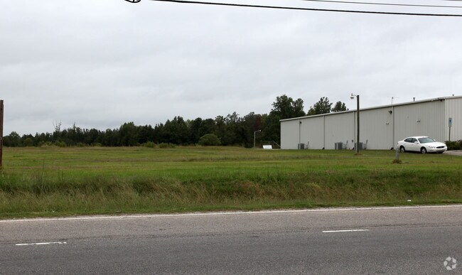
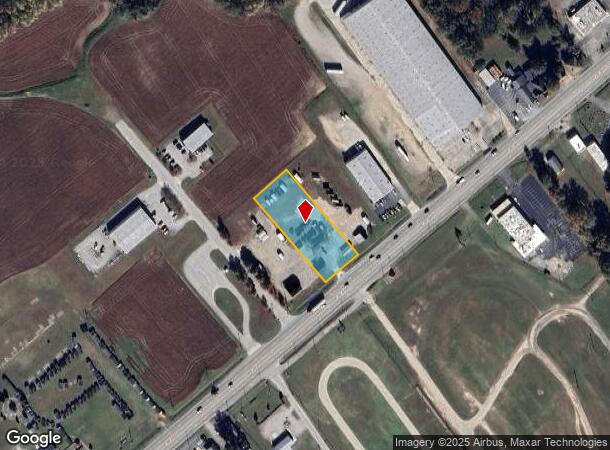
Property Record
2302 Us Highway 301 S, Wilson, NC 27893
NEARBY LISTINGS FOR SALE OR LEASE
Property Detail
2302 Us Highway 301 S
3711-61-8691.000
2302 US 301 HWY S MOD OFFICE ONLY 1.00UT
Mobilecommercialunits
Wilson
X
North Carolina
3720371100K
1.10 AC
2024
Rocky Mount/Wilson
2025
Other Market Areas
000402
Wilson, NC
396 SF
DEMOGRAPHICS near 2302 Us Highway 301 S
1 Mile
3 Mile
5 Mile
2024 Total Population
2,680
27,964
50,649
2029 Population
2,683
28,300
50,985
Pop Growth 2024-2029
+ 0.11%
+ 1.20%
+ 0.66%
Average Age
42
41
41
2024 Total Households
1,063
11,605
21,103
HH Growth 2024-2029
0.00%
+ 1.12%
+ 0.63%
Median Household Inc
$49,429
$38,126
$45,684
Avg Household Size
2.30
2.30
2.30
2024 Avg HH Vehicles
2.00
1.00
2.00
Median Home Value
$87,153
$126,509
$146,690
Median Year Built
1979
1975
1982
Nearby Places
Map Layers
Map Styles
 Street
 Aerial
- Restaurants
- Banks
- Shops
- Fitness
- Groceries
PUBLIC TRANSPORTATION
COMMUTER RAIL
Wilson (Carolinian - Amtrak, Palmetto - Amtrak)
DRIVE
WALK
Distance
Wilson (Carolinian - Amtrak, Palmetto - Amtrak)
5 min
2.4 mi
Freight Ports
Port of Morehead City
DRIVE
WALK
Distance
Port of Morehead City
165 min
125.6 mi
SALE & LEASE HISTORY
LISTING DATE
SALE/LEASE

Sep 25, 2016
For Lease
Sep 24, 2016
For Sale
Nearby Properties
Address
Land Use
TOTAL SIZE
Lot Size
Zoning
Address
Land Use
TOTAL SIZE
Lot Size
Zoning
11,771 SF
31.78 AC
ICD
Address
Land Use
TOTAL SIZE
Lot Size
Zoning
21,655 SF
34.44 AC
ICD
Address
Land Use
TOTAL SIZE
Lot Size
Zoning
220,639 SF
1.94 AC
CCMX
Address
Land Use
TOTAL SIZE
Lot Size
Zoning
259,000 SF
69.97 AC
HI
Address
Land Use
TOTAL SIZE
Lot Size
Zoning
10,152 SF
29.71 AC
ICD
Address
Land Use
TOTAL SIZE
Lot Size
Zoning
59,319 SF
1.01 AC
CCMX
Address
Land Use
TOTAL SIZE
Lot Size
Zoning
77,125 SF
2.98 AC
GC
Address
Land Use
TOTAL SIZE
Lot Size
Zoning
150,316 SF
10.97 AC
RMX
Address
Land Use
TOTAL SIZE
Lot Size
Zoning
90,035 SF
91.87 AC
ICD
Address
Land Use
TOTAL SIZE
Lot Size
Zoning
80,000 SF
101.30 AC
HI
Address
Land Use
TOTAL SIZE
Lot Size
Zoning
185,515 SF
19.58 AC
HC
Address
Land Use
TOTAL SIZE
Lot Size
Zoning
25,888 SF
73.36 AC
LI
Address
Land Use
TOTAL SIZE
Lot Size
Zoning
192,420 SF
34.36 AC
HI
Address
Land Use
TOTAL SIZE
Lot Size
Zoning
91,637 SF
1.95 AC
CCMX
Address
Land Use
TOTAL SIZE
Lot Size
Zoning
78,875 SF
34.82 AC
ICD
Address
Land Use
TOTAL SIZE
Lot Size
Zoning
133,549 SF
21.49 AC
HC
Address
Land Use
TOTAL SIZE
Lot Size
Zoning
1,944 SF
13.64 AC
GR6
Address
Land Use
TOTAL SIZE
Lot Size
Zoning
13,672 SF
7.68 AC
NC
Address
Land Use
TOTAL SIZE
Lot Size
Zoning
8,616 SF
40 AC
ICD
Address
Land Use
TOTAL SIZE
Lot Size
Zoning
20,705 SF
7.88 AC
GR6
Address
Land Use
TOTAL SIZE
Lot Size
Zoning
35,406 SF
2.91 AC
GR6
Address
Land Use
TOTAL SIZE
Lot Size
Zoning
12,560 SF
11.89 AC
HC
Address
Land Use
TOTAL SIZE
Lot Size
Zoning
3,900 SF
16.46 AC
RMX
Address
Land Use
TOTAL SIZE
Lot Size
Zoning
7,552 SF
51.19 AC
HI
Address
Land Use
TOTAL SIZE
Lot Size
Zoning
74,555 SF
2.37 AC
CCMX
Address
Land Use
TOTAL SIZE
Lot Size
Zoning
112,721 SF
22.04 AC
GC
Address
Land Use
TOTAL SIZE
Lot Size
Zoning
7,350 SF
9.09 AC
GC
Address
Land Use
TOTAL SIZE
Lot Size
Zoning
17,136 SF
9.81 AC
GC
Address
Land Use
TOTAL SIZE
Lot Size
Zoning
108,510 SF
1.47 AC
CCMX
Address
Land Use
TOTAL SIZE
Lot Size
Zoning
129,404 SF
2.61 AC
HI
The World's #1 Commercial Real Estate Marketplace
Connect with us
© 2025 CoStar Group
The information above has been obtained from sources believed reliable. While we do not doubt its accuracy we have not verified it and make no guarantee, warranty or representation about it. It is your responsibility to independently confirm its accuracy and completeness. Any projections, opinions, assumptions, or estimates used are for example only and do not represent the current or future performance of the property. The value of this transaction to you depends on tax and other factors which should be evaluated by your tax, financial, and legal advisors. You and your advisors should conduct a careful, independent investigation of the property to determine to your satisfaction the suitability of the property for your needs.