Property Record
23028 589Th Ave, Mankato, MN 56001

Property Detail
23028 589Th Ave
Mankato, MN
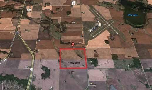
NE4 EXC 3.54A RR & EXC 6.03A CSAH 12 034 109 26 150.20AC
R40-04-34-200-001
BLUE EARTH
Agriculturalland
Minnesota
B and X Area of moderate flood hazard, usually the area between the limits of the 100-year and 500-year floods.
150.20 AC
2026
Minnesota South Area
2026
Other Market Areas
170200
NEARBY LISTINGS FOR SALE OR LEASE
DEMOGRAPHICS near 23028 589Th Ave
1 mile
3 mile
5 mile
2025 Total Population
191
6,594
41,817
2030 Population
199
6,816
42,479
Pop Growth 2025-2030
+ 4.19%
+ 3.37%
+ 1.58%
Average Age
33
38
37
2025 Total Households
82
2,757
17,647
HH Growth 2025-2030
+ 4.88%
+ 3.55%
+ 1.69%
Median Household Inc
$72,717
$87,598
$66,478
Avg Household Size
2.30
2.40
2.20
2025 Avg HH Vehicles
2.00
2.00
2.00
Median Home Value
$358,695
$345,417
$270,251
Median Year Built
2011
2007
1981
Nearby Places
Map Layers
Map Styles
 Street
 Aerial
Layers
 Traffic
 Biking
Places
Listings with unknown addresses are not visible on the map
- Restaurants
- Banks
- Shops
- Fitness
- Groceries
SALE & LEASE HISTORY
LISTING DATE
SALE/LEASE

Sep 24, 2016
For Sale
Mar 29, 2018
For Sale
Nearby Properties
Address
Land Use
TOTAL SIZE
Lot Size
Zoning
Address
Land Use
TOTAL SIZE
Lot Size
Zoning
458,428 SF
138.79 AC
Address
Land Use
TOTAL SIZE
Lot Size
Zoning
481,569 SF
31.57 AC
Address
Land Use
TOTAL SIZE
Lot Size
Zoning
329,820 SF
18.94 AC
Address
Land Use
TOTAL SIZE
Lot Size
Zoning
15,988 SF
735.32 AC
Address
Land Use
TOTAL SIZE
Lot Size
Zoning
47,274 SF
17.47 AC
Address
Land Use
TOTAL SIZE
Lot Size
Zoning
168,908 SF
5.71 AC
Address
Land Use
TOTAL SIZE
Lot Size
Zoning
97,508 SF
44.54 AC
Address
Land Use
TOTAL SIZE
Lot Size
Zoning
63,880 SF
9.19 AC
Address
Land Use
TOTAL SIZE
Lot Size
Zoning
182,498 SF
23.67 AC
Address
Land Use
TOTAL SIZE
Lot Size
Zoning
279,442 SF
24.04 AC
Address
Land Use
TOTAL SIZE
Lot Size
Zoning
110,608 SF
8.55 AC
Address
Land Use
TOTAL SIZE
Lot Size
Zoning
107,485 SF
11.13 AC
Address
Land Use
TOTAL SIZE
Lot Size
Zoning
3.14 AC
Address
Land Use
TOTAL SIZE
Lot Size
Zoning
90,180 SF
14.40 AC
Address
Land Use
TOTAL SIZE
Lot Size
Zoning
126,842 SF
8.31 AC
Address
Land Use
TOTAL SIZE
Lot Size
Zoning
2.69 AC
Address
Land Use
TOTAL SIZE
Lot Size
Zoning
3.33 AC
Address
Land Use
TOTAL SIZE
Lot Size
Zoning
3.05 AC
Address
Land Use
TOTAL SIZE
Lot Size
Zoning
2.54 AC
Address
Land Use
TOTAL SIZE
Lot Size
Zoning
5.05 AC
Address
Land Use
TOTAL SIZE
Lot Size
Zoning
36,226 SF
6.58 AC
Address
Land Use
TOTAL SIZE
Lot Size
Zoning
4.06 AC
Address
Land Use
TOTAL SIZE
Lot Size
Zoning
194,826 SF
14.57 AC
Address
Land Use
TOTAL SIZE
Lot Size
Zoning
3.08 AC
Address
Land Use
TOTAL SIZE
Lot Size
Zoning
34,945 SF
4.55 AC
The World's #1 Commercial Real Estate Marketplace
Connect with us
© 2026 CoStar Group
The information above has been obtained from sources believed reliable. While we do not doubt its accuracy we have not verified it and make no guarantee, warranty or representation about it. It is your responsibility to independently confirm its accuracy and completeness. Any projections, opinions, assumptions, or estimates used are for example only and do not represent the current or future performance of the property. The value of this transaction to you depends on tax and other factors which should be evaluated by your tax, financial, and legal advisors. You and your advisors should conduct a careful, independent investigation of the property to determine to your satisfaction the suitability of the property for your needs.