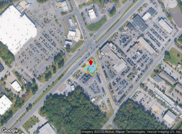
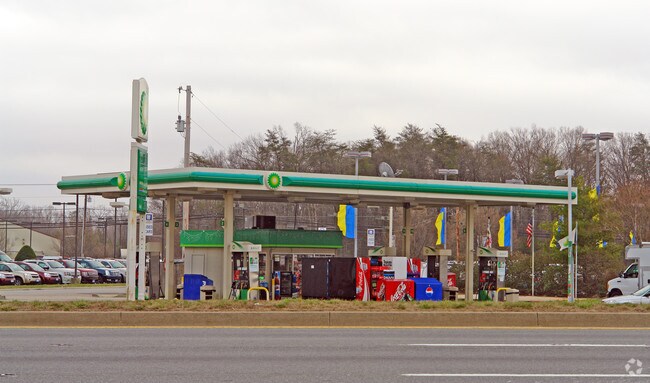
Property Record
2304 Crain Hwy, Waldorf, MD 20601

NEARBY LISTINGS FOR SALE OR LEASE
Property Detail
2304 Crain Hwy
Washington-Arlington-Alexandria, DC-VA-MD-WV
Town Of La Plata
06-059759
.2369 AC S/E SI RT 301 GAS N GO
Commercialnec
Charles
X
Maryland
24033C0345E
0.24 AC
0
Charles County
2025
Washington, DC
850802
DEMOGRAPHICS near 2304 Crain Hwy
1 Mile
3 Mile
5 Mile
2024 Total Population
8,245
37,713
92,372
2029 Population
8,629
39,145
95,813
Pop Growth 2024-2029
+ 4.66%
+ 3.80%
+ 3.73%
Average Age
36
38
38
2024 Total Households
3,104
13,719
32,892
HH Growth 2024-2029
+ 4.61%
+ 3.80%
+ 3.76%
Median Household Inc
$85,087
$97,919
$103,831
Avg Household Size
2.60
2.70
2.70
2024 Avg HH Vehicles
2.00
2.00
2.00
Median Home Value
$271,771
$335,016
$358,643
Median Year Built
1989
1989
1991
Nearby Places
Map Layers
Map Styles
 Street
 Aerial
- Restaurants
- Banks
- Shops
- Fitness
- Groceries
PUBLIC TRANSPORTATION
AIRPORT
Ronald Reagan Washington Ntl
DRIVE
WALK
Distance
Ronald Reagan Washington Ntl
41 min
25.1 mi
Freight Ports
Port of Baltimore
DRIVE
WALK
Distance
Port of Baltimore
76 min
52.0 mi
Nearby Properties
Address
Land Use
TOTAL SIZE
Lot Size
Zoning
Address
Land Use
TOTAL SIZE
Lot Size
Zoning
7,670 SF
9.78 AC
TACC
Address
Land Use
TOTAL SIZE
Lot Size
Zoning
392,898 SF
36.37 AC
PRD
Address
Land Use
TOTAL SIZE
Lot Size
Zoning
617,760 SF
25.75 AC
IE
Address
Land Use
TOTAL SIZE
Lot Size
Zoning
477,958 SF
47.50 AC
CB
Address
Land Use
TOTAL SIZE
Lot Size
Zoning
312,478 SF
54.26 AC
PUD
Address
Land Use
TOTAL SIZE
Lot Size
Zoning
265,637 SF
54.72 AC
RH
Address
Land Use
TOTAL SIZE
Lot Size
Zoning
206,966 SF
32.61 AC
CB
Address
Land Use
TOTAL SIZE
Lot Size
Zoning
188,284 SF
9.02 AC
RM
Address
Land Use
TOTAL SIZE
Lot Size
Zoning
262,779 SF
26.84 AC
CB
Address
Land Use
TOTAL SIZE
Lot Size
Zoning
239,208 SF
13.51 AC
PUD
Address
Land Use
TOTAL SIZE
Lot Size
Zoning
177,540 SF
27.64 AC
WCD
Address
Land Use
TOTAL SIZE
Lot Size
Zoning
177,540 SF
12.66 AC
WCD
Address
Land Use
TOTAL SIZE
Lot Size
Zoning
167,075 SF
11.01 AC
RH
Address
Land Use
TOTAL SIZE
Lot Size
Zoning
237,903 SF
16.03 AC
PRD
Address
Land Use
TOTAL SIZE
Lot Size
Zoning
156,118 SF
17.01 AC
TACE
Address
Land Use
TOTAL SIZE
Lot Size
Zoning
62,838 SF
7.77 AC
TACE
Address
Land Use
TOTAL SIZE
Lot Size
Zoning
161,208 SF
10.99 AC
RH
Address
Land Use
TOTAL SIZE
Lot Size
Zoning
67,608 SF
4.01 AC
TACC
Address
Land Use
TOTAL SIZE
Lot Size
Zoning
160,985 SF
24.85 AC
CB
Address
Land Use
TOTAL SIZE
Lot Size
Zoning
98.41 AC
IH
Address
Land Use
TOTAL SIZE
Lot Size
Zoning
143,728 SF
19.71 AC
CB
Address
Land Use
TOTAL SIZE
Lot Size
Zoning
194,972 SF
59.84 AC
RH
Address
Land Use
TOTAL SIZE
Lot Size
Zoning
132,745 SF
2.59 AC
CC
Address
Land Use
TOTAL SIZE
Lot Size
Zoning
109,304 SF
9.09 AC
PUD
Address
Land Use
TOTAL SIZE
Lot Size
Zoning
54,899 SF
5.23 AC
TACE
Address
Land Use
TOTAL SIZE
Lot Size
Zoning
128,909 SF
10.77 AC
TACE
Address
Land Use
TOTAL SIZE
Lot Size
Zoning
62,442 SF
4.84 AC
TACE
Address
Land Use
TOTAL SIZE
Lot Size
Zoning
191,746 SF
10.46 AC
PUD
Address
Land Use
TOTAL SIZE
Lot Size
Zoning
90,238 SF
4.50 AC
CB
Address
Land Use
TOTAL SIZE
Lot Size
Zoning
28,508 SF
10 AC
TACC
The World's #1 Commercial Real Estate Marketplace
Connect with us
© 2025 CoStar Group
The information above has been obtained from sources believed reliable. While we do not doubt its accuracy we have not verified it and make no guarantee, warranty or representation about it. It is your responsibility to independently confirm its accuracy and completeness. Any projections, opinions, assumptions, or estimates used are for example only and do not represent the current or future performance of the property. The value of this transaction to you depends on tax and other factors which should be evaluated by your tax, financial, and legal advisors. You and your advisors should conduct a careful, independent investigation of the property to determine to your satisfaction the suitability of the property for your needs.