Property Record
2304 E Gore Blvd, Lawton, OK 73501
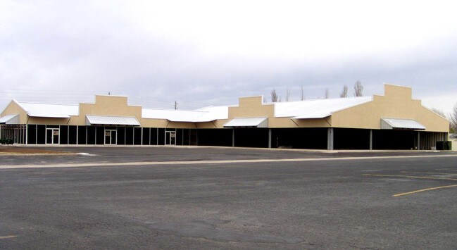

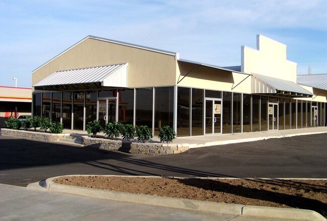
Property Detail
2304 E Gore Blvd
Lawton, OK
28-2N-11W C T BEG AT A PT ON S LNE SE/4; 315' E OF SW/C SE/4 THN N 185', W 60', N 215', W 255', S 155', E 110', S 245', E 205
0043554
COMANCHE
Commercialbuilding
Oklahoma
B and X Area of moderate flood hazard, usually the area between the limits of the 100-year and 500-year floods.
8
2025
1.58 AC
2025
Oklahoma West Area
002001
Other Market Areas
16,382 SF
NEARBY LISTINGS FOR SALE OR LEASE
DEMOGRAPHICS near 2304 E Gore Blvd
1 mile
3 mile
5 mile
2025 Total Population
3,452
25,697
61,770
2030 Population
3,493
25,872
62,246
Pop Growth 2025-2030
+ 1.19%
+ 0.68%
+ 0.77%
Average Age
36
39
36
2025 Total Households
1,527
9,937
22,240
HH Growth 2025-2030
+ 0.98%
+ 0.80%
+ 0.99%
Median Household Inc
$57,856
$54,482
$48,867
Avg Household Size
2.20
2.30
2.40
2025 Avg HH Vehicles
2.00
2.00
1.00
Median Home Value
$145,370
$146,864
$123,329
Median Year Built
1988
1974
1971
Nearby Places
Map Layers
Map Styles
 Street
 Aerial
Layers
 Traffic
 Biking
Places
Listings with unknown addresses are not visible on the map
- Restaurants
- Banks
- Shops
- Fitness
- Groceries
PUBLIC TRANSPORTATION
AIRPORT
Lawton-Fort Sill Regional
Drive
Walk
Distance
Lawton-Fort Sill Regional
14 min
6.8 mi
Freight Ports
Tulsa Port Of Catoosa
Drive
Walk
Distance
Tulsa Port Of Catoosa
225 min
209.9 mi
Nearby Properties
Address
Land Use
TOTAL SIZE
Lot Size
Zoning
Address
Land Use
TOTAL SIZE
Lot Size
Zoning
74,800 SF
4.77 AC
Address
Land Use
TOTAL SIZE
Lot Size
Zoning
2,288 SF
2.94 AC
Address
Land Use
TOTAL SIZE
Lot Size
Zoning
14,523 SF
14.99 AC
Address
Land Use
TOTAL SIZE
Lot Size
Zoning
52,295 SF
2.50 AC
Address
Land Use
TOTAL SIZE
Lot Size
Zoning
22,987 SF
6.60 AC
Address
Land Use
TOTAL SIZE
Lot Size
Zoning
14,000 SF
17.18 AC
Address
Land Use
TOTAL SIZE
Lot Size
Zoning
3,200 SF
6.49 AC
Address
Land Use
TOTAL SIZE
Lot Size
Zoning
114,352 SF
2.63 AC
Address
Land Use
TOTAL SIZE
Lot Size
Zoning
35,582 SF
3.77 AC
Address
Land Use
TOTAL SIZE
Lot Size
Zoning
63,223 SF
5.75 AC
Address
Land Use
TOTAL SIZE
Lot Size
Zoning
13,800 SF
13.13 AC
Address
Land Use
TOTAL SIZE
Lot Size
Zoning
2,688 SF
4.50 AC
Address
Land Use
TOTAL SIZE
Lot Size
Zoning
6,251 SF
5.07 AC
Address
Land Use
TOTAL SIZE
Lot Size
Zoning
14,620 SF
1.13 AC
Address
Land Use
TOTAL SIZE
Lot Size
Zoning
52,568 SF
1.50 AC
Address
Land Use
TOTAL SIZE
Lot Size
Zoning
2,940 SF
7.82 AC
Address
Land Use
TOTAL SIZE
Lot Size
Zoning
61,984 SF
1.58 AC
Address
Land Use
TOTAL SIZE
Lot Size
Zoning
23,800 SF
4.34 AC
Address
Land Use
TOTAL SIZE
Lot Size
Zoning
11,368 SF
7.42 AC
Address
Land Use
TOTAL SIZE
Lot Size
Zoning
46,400 SF
2.50 AC
Address
Land Use
TOTAL SIZE
Lot Size
Zoning
88,460 SF
5.55 AC
Address
Land Use
TOTAL SIZE
Lot Size
Zoning
4,950 SF
0.69 AC
Address
Land Use
TOTAL SIZE
Lot Size
Zoning
55,456 SF
3.70 AC
Address
Land Use
TOTAL SIZE
Lot Size
Zoning
27,300 SF
3.15 AC
Address
Land Use
TOTAL SIZE
Lot Size
Zoning
48,290 SF
2.02 AC
Address
Land Use
TOTAL SIZE
Lot Size
Zoning
40,632 SF
4.96 AC
Address
Land Use
TOTAL SIZE
Lot Size
Zoning
50,972 SF
1.64 AC
Address
Land Use
TOTAL SIZE
Lot Size
Zoning
14,897 SF
2.75 AC
Address
Land Use
TOTAL SIZE
Lot Size
Zoning
2,442 SF
3.81 AC
Address
Land Use
TOTAL SIZE
Lot Size
Zoning
27,815 SF
2.76 AC
The World's #1 Commercial Real Estate Marketplace
Connect with us
© 2026 CoStar Group
The information above has been obtained from sources believed reliable. While we do not doubt its accuracy we have not verified it and make no guarantee, warranty or representation about it. It is your responsibility to independently confirm its accuracy and completeness. Any projections, opinions, assumptions, or estimates used are for example only and do not represent the current or future performance of the property. The value of this transaction to you depends on tax and other factors which should be evaluated by your tax, financial, and legal advisors. You and your advisors should conduct a careful, independent investigation of the property to determine to your satisfaction the suitability of the property for your needs.