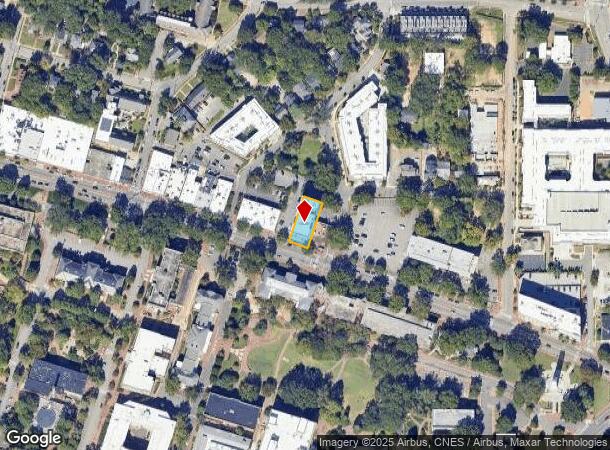
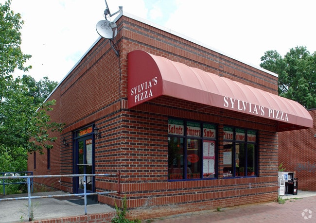
Property Record
2304 Hillsborough St, Raleigh, NC 27607

NEARBY LISTINGS FOR SALE OR LEASE
Property Detail
2304 Hillsborough St
Raleigh-Cary, NC
Harris-Chamberlin Subdivision
0794.20-91-0704-000
LO17 HARRIS CHAMBERLAIN BM1915-50
Apartment
Wake
X
North Carolina
3720079400K
17
2025
0.21 AC
2025
West Raleigh
051200
Raleigh/Durham
32,147 SF
DEMOGRAPHICS near 2304 Hillsborough St
1 Mile
3 Mile
5 Mile
2024 Total Population
20,664
107,419
231,202
2029 Population
22,277
117,068
251,883
Pop Growth 2024-2029
+ 7.81%
+ 8.98%
+ 8.94%
Average Age
32
35
36
2024 Total Households
7,928
45,281
99,790
HH Growth 2024-2029
+ 9.73%
+ 9.70%
+ 9.35%
Median Household Inc
$60,050
$70,780
$69,180
Avg Household Size
1.70
2.00
2.10
2024 Avg HH Vehicles
2.00
2.00
2.00
Median Home Value
$629,774
$529,972
$424,215
Median Year Built
1986
1985
1988
Nearby Places
Map Layers
Map Styles
 Street
 Aerial
- Restaurants
- Banks
- Shops
- Fitness
- Groceries
PUBLIC TRANSPORTATION
AIRPORT
Raleigh-Durham International
DRIVE
WALK
Distance
Raleigh-Durham International
16 min
11.4 mi
Freight Ports
Port of Wilmington
DRIVE
WALK
Distance
Port of Wilmington
1 min
117.3 mi
Nearby Properties
Address
Land Use
TOTAL SIZE
Lot Size
Zoning
Address
Land Use
TOTAL SIZE
Lot Size
Zoning
5,616,802 SF
507.97 AC
OX-12
Address
Land Use
TOTAL SIZE
Lot Size
Zoning
972,279 SF
4.05 AC
DX-20
Address
Land Use
TOTAL SIZE
Lot Size
Zoning
1,109,877 SF
746.53 AC
CMP
Address
Land Use
TOTAL SIZE
Lot Size
Zoning
1,597,789 SF
13.35 AC
DX-20
Address
Land Use
TOTAL SIZE
Lot Size
Zoning
1,801,169 SF
59.60 AC
OX-12
Address
Land Use
TOTAL SIZE
Lot Size
Zoning
854,180 SF
210.81 AC
OX-4
Address
Land Use
TOTAL SIZE
Lot Size
Zoning
458,830 SF
3.98 AC
DX-20
Address
Land Use
TOTAL SIZE
Lot Size
Zoning
294,812 SF
999.47 AC
AP
Address
Land Use
TOTAL SIZE
Lot Size
Zoning
613,087 SF
266.85 AC
PD
Address
Land Use
TOTAL SIZE
Lot Size
Zoning
1,810,132 SF
OX-12
Address
Land Use
TOTAL SIZE
Lot Size
Zoning
706,810 SF
40.78 AC
IH
Address
Land Use
TOTAL SIZE
Lot Size
Zoning
675,817 SF
3.56 AC
DX-12
Address
Land Use
TOTAL SIZE
Lot Size
Zoning
372,222 SF
9.64 AC
DX-12
Address
Land Use
TOTAL SIZE
Lot Size
Zoning
403,230 SF
197.34 AC
IX-3
Address
Land Use
TOTAL SIZE
Lot Size
Zoning
250,448 SF
25.28 AC
OX-3
Address
Land Use
TOTAL SIZE
Lot Size
Zoning
982,323 SF
154.02 AC
OX-7
Address
Land Use
TOTAL SIZE
Lot Size
Zoning
517,826 SF
2.52 AC
DX-7
Address
Land Use
TOTAL SIZE
Lot Size
Zoning
179,565 SF
1.10 AC
DX-7
Address
Land Use
TOTAL SIZE
Lot Size
Zoning
524,391 SF
4.13 AC
NX-5
Address
Land Use
TOTAL SIZE
Lot Size
Zoning
344,814 SF
1.95 AC
DX-40
Address
Land Use
TOTAL SIZE
Lot Size
Zoning
654,148 SF
1.21 AC
DX-40
Address
Land Use
TOTAL SIZE
Lot Size
Zoning
462,217 SF
1.01 AC
DX-20
Address
Land Use
TOTAL SIZE
Lot Size
Zoning
834,950 SF
3.91 AC
OX-12
Address
Land Use
TOTAL SIZE
Lot Size
Zoning
561,966 SF
3.81 AC
IX-7
Address
Land Use
TOTAL SIZE
Lot Size
Zoning
426,539 SF
2.90 AC
NX-5
Address
Land Use
TOTAL SIZE
Lot Size
Zoning
765,252 SF
1.72 AC
DX-20
Address
Land Use
TOTAL SIZE
Lot Size
Zoning
159,921 SF
4.99 AC
DX-5
Address
Land Use
TOTAL SIZE
Lot Size
Zoning
376,902 SF
189.85 AC
OX-3
Address
Land Use
TOTAL SIZE
Lot Size
Zoning
40,024 SF
6.19 AC
DX-3
Address
Land Use
TOTAL SIZE
Lot Size
Zoning
613,248 SF
2.20 AC
IND-2
The World's #1 Commercial Real Estate Marketplace
Connect with us
© 2026 CoStar Group
The information above has been obtained from sources believed reliable. While we do not doubt its accuracy we have not verified it and make no guarantee, warranty or representation about it. It is your responsibility to independently confirm its accuracy and completeness. Any projections, opinions, assumptions, or estimates used are for example only and do not represent the current or future performance of the property. The value of this transaction to you depends on tax and other factors which should be evaluated by your tax, financial, and legal advisors. You and your advisors should conduct a careful, independent investigation of the property to determine to your satisfaction the suitability of the property for your needs.